Kyushu
Kyushu (九州, Kyūshū, pronounced [kʲɯꜜːɕɯː] (![]()
| Native name: 九州 | |
|---|---|
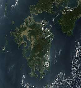 Satellite picture of Kyushu | |
.svg.png) Kyushu region of Japan and the current prefectures on the island of Kyushu | |
| Geography | |
| Location | East Asia |
| Archipelago | Japanese Archipelago |
| Area | 36,782 km2 (14,202 sq mi) |
| Area rank | 37th |
| Coastline | 12,221 km (7,593.8 mi) |
| Highest elevation | 1,791 m (5,876 ft) |
| Highest point | Mount Kujū[1] |
| Administration | |
| Prefectures | |
| Largest settlement | Fukuoka |
| Demographics | |
| Population | 12,970,479 (2016) |
| Pop. density | 307.13/km2 (795.46/sq mi) |
| Ethnic groups | Japanese, Ryukyuan |
In the 8th-century Taihō Code reforms, Dazaifu was established as a special administrative term for the region.[4]
As of 2016, Kyushu has a population of 12,970,479 and covers 36,782 square kilometres (14,202 sq mi).[5]
Geography

The island is mountainous, and Japan's most active volcano, Mt Aso at 1,591 metres (5,220 ft), is on Kyushu. There are many other signs of tectonic activity, including numerous areas of hot springs. The most famous of these are in Beppu, on the east shore, and around Mt. Aso, in central Kyushu. The island is separated from Honshu by the Kanmon Straits. Kyushu is the nearest to the Asian continent which made it the gateway to Japan.[6]
The name Kyūshū comes from the nine ancient provinces of Saikaidō situated on the island: Chikuzen, Chikugo, Hizen, Higo, Buzen, Bungo, Hyūga, Osumi, and Satsuma.[7]
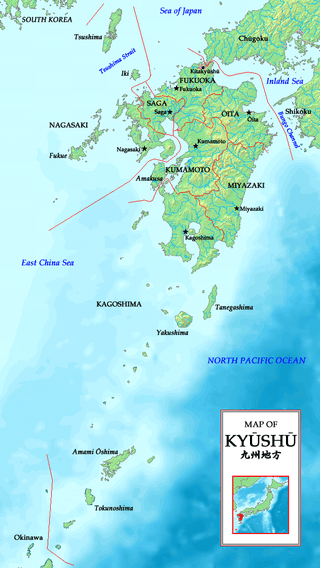
Today's Kyushu Region (九州地方, Kyūshū-chihō) is a politically defined region that consists of the seven prefectures on the island of Kyushu (which also includes the former Tsushima and Iki as part of Nagasaki), plus Okinawa Prefecture to the south:
- Northern Kyushu
- Fukuoka Prefecture
- Kumamoto Prefecture
- Nagasaki Prefecture
- Ōita Prefecture
- Saga Prefecture
- Southern Kyushu
- Kagoshima Prefecture
- Miyazaki Prefecture
- Okinawa Prefecture
Population
Kyushu has 10.3 percent of the population of Japan.[8] Most of Kyushu's population is concentrated along the northwest, in the cities of Fukuoka and Kitakyushu, with population corridors stretching southwest into Sasebo and Nagasaki and south into Kumamoto and Kagoshima. Except for Oita and Miyazaki, the eastern seaboard shows a general decline in population.
Kyushu is described as a stronghold of the Liberal Democratic Party.[9]
Designated cities
- Fukuoka (population: 1,588,924)
- Kitakyushu (population: 940,978)
- Kumamoto (population: 738,907)
Core cities
- Kagoshima
- Ōita
- Nagasaki
- Miyazaki
- Naha
- Kurume
- Sasebo
- Saga
Economy and environment
Parts of Kyushu have a subtropical climate, particularly Miyazaki prefecture and Kagoshima prefecture. Major agricultural products are rice, tea, tobacco, sweet potatoes, and soy; also, silk is widely produced. The island is noted for various types of porcelain, including Arita, Imari, Satsuma, and Karatsu. Heavy industry is concentrated in the north around Fukuoka, Kitakyushu, Nagasaki, and Oita and includes chemicals, automobiles, semiconductors, and metal processing.
In 2010, the graduate employment rate in the region was the lowest nationwide, at 88.9%.[10]
Besides the volcanic area of the south, there are significant mud hot springs in the northern part of the island, around Beppu. The springs are the site of occurrence of certain extremophile microorganisms, which are capable of surviving in extremely hot environments.[11]
Education
Major universities and colleges in Kyushu:
- National universities
- Kyushu University – One of seven former "Imperial Universities"
- Kyushu Institute of Technology
- Saga University
- Nagasaki University
- Kumamoto University
- Fukuoka University of Education
- Oita University
- Miyazaki University
- Kagoshima University
- National Institute of Fitness and Sports in Kanoya
- University of the Ryukyus
- Universities run by local governments
- University of Kitakyushu
- Kyushu Dental College
- Fukuoka Women's University
- Fukuoka Prefectural University
- Nagasaki Prefectural University
- Oita University of Nursing and Health Sciences
- Prefectural University of Kumamoto
- Miyazaki Municipal University
- Miyazaki Prefectural Nursing University
- Okinawa Prefectural University of Arts
- Major private universities
- Fukuoka University – University with the largest number of students in Kyushu
- Kumamoto Gakuen University
- Ritsumeikan Asia Pacific University
- Seinan Gakuin University
- Kyushu Sangyo University – Baseball team won the Japanese National Championship in 2005
- University of Occupational and Environmental Health
- Kurume University
Transportation
The island is linked to the larger island of Honshu by the Kanmon Tunnels, which carry both the San'yō Shinkansen and non-Shinkansen trains of the Kyushu Railway Company, as well as vehicular, pedestrian, and bicycle traffic. The Kanmon Bridge also connects the island with Honshu. Railways on the island are operated by the Kyushu Railway Company, and Nishitetsu Railway.
See also
| Look up Kyushu or Islands in Wiktionary, the free dictionary. |
- Japanese archipelago
- Geography of Japan
- List of regions in Japan
- Northern Kyushu, Southern Kyushu
- Azumi people, an ancient group of people who inhabited parts of northern Kyūshū
- Group Kyushu
- Western Army (Japan)
- United States Fleet Activities Sasebo
- Hoenn, a fictional region in the Pokémon franchise which is based on Kyushu
- Kanmonkyo Bridge, that connects Kyūshū with Honshū
- Kyushu National Museum
- Kyushu dialects, Hichiku dialect, Hōnichi dialect and Kagoshima dialect
Notes
| Wikimedia Commons has media related to: |
| Wikivoyage has a travel guide for Kyushu. |
- "Kujū-san, Japan". Peakbagger.com.
- "離島とは(島の基礎知識) (what is a remote island?)". MLIT (Ministry of Land, Infrastructure, Transport and Tourism) (in Japanese). Ministry of Land, Infrastructure, Transport and Tourism. 22 August 2015. Archived from the original (website) on 2007-07-13. Retrieved 9 August 2019.
MILT classification 6,852 islands(main islands: 5 islands, remote islands: 6,847 islands)
- Nussbaum, Louis-Frédéric. (2005). "Kyūshū" in Japan Encyclopedia, p. 588, p. 588, at Google Books
- Nussbaum, "Dazaifu" in p. 150, p. 150, at Google Books; Dazaifu
- "Discover the Geography of the 4 Main Islands of Japan". ThoughtCo. Retrieved 2018-09-26.
- Cobbing, Andrew (2009). Kyushu, gateway to Japan : a concise history. Global Oriental. p. 157. ISBN 9789004213128. OCLC 754792858.
- Cobbing, Andrew (2009). Kyushu, gateway to Japan : a concise history. Global Oriental. p. 3. ISBN 9789004213128. OCLC 754792858.
- Boquet, Yves (2017). The Philippine Archipelago. Springer. p. 16. ISBN 9783319519265.
- "Japanese voters want a plan to handle a declining population". The Economist. 5 October 2017.
- "Grads landing jobs near all-time low". The Japan Times. May 22, 2010. Retrieved 22 October 2010.
- C.Michael Hogan. 2010. Extremophile. eds. E.Monosson and C.Cleveland. Encyclopedia of Earth. National Council for Science and the Environment, Washington DC
References
- Nussbaum, Louis-Frédéric and Käthe Roth. (2005). Japan encyclopedia. Cambridge: Harvard University Press. ISBN 978-0-674-01753-5; OCLC 58053128
| Regions |  | ||||||||||||||||
|---|---|---|---|---|---|---|---|---|---|---|---|---|---|---|---|---|---|
| 47 Prefectures |
| ||||||||||||||||