Jilin
Jilin (![]()

Jilin Province 吉林省 | |
|---|---|
Province | |
| Name transcription(s) | |
| • Chinese | 吉林省 (Jílín Shěng) |
| • Abbreviation | JL / 吉 (pinyin: Jí) |
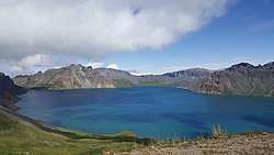 View of Heaven Lake | |
.svg.png) Map showing the location of Jilin Province | |
| Coordinates: 43°42′N 126°12′E | |
| Named for | from girin ula, a Manchu phrase meaning "along the river" |
| Capital (and largest city) | |
| Divisions | 9 prefectures, 60 counties, 1006 townships |
| Government | |
| • Secretary | Bayanqolu |
| • Governor | Jing Junhai |
| Area | |
| • Total | 191,126 km2 (73,794 sq mi) |
| Area rank | 14th |
| Highest elevation | 2,744 m (9,003 ft) |
| Population (2010)[2] | |
| • Total | 27,462,297 |
| • Rank | 21st |
| • Density | 140/km2 (370/sq mi) |
| • Density rank | 23rd |
| Demographics | |
| • Ethnic composition | |
| • Languages and dialects | Northeastern Mandarin, Hamgyŏng Korean |
| ISO 3166 code | CN-JL |
| GDP (2017 [3]) | CNY 1.53 trillion (US$226.44 billion) (23nd) |
| • per capita | CNY 56,101 (US$8,309) (13th) |
| HDI (2018) | |
| Website | www |
| Jilin | |||||||||||||||
|---|---|---|---|---|---|---|---|---|---|---|---|---|---|---|---|
"Jilin" in Chinese characters | |||||||||||||||
| Chinese name | |||||||||||||||
| Chinese | 吉林 | ||||||||||||||
| Postal | Kirin | ||||||||||||||
| Literal meaning | transcription of "girin (ula)" a Manchu phrase meaning "along the river" | ||||||||||||||
| |||||||||||||||
| Chinese Korean name | |||||||||||||||
| Chosŏn'gŭl | 길림 | ||||||||||||||
| |||||||||||||||
| Manchu name | |||||||||||||||
| Manchu script | ᡤᡳᡵᡳᠨ ᠮᡤᠣᠯᠣ | ||||||||||||||
| Romanization | Girin golo | ||||||||||||||
The Manchu people once inhabited the area of Jilin, thus making Jilin part of the historical region of Manchuria. The area had been heavily contested, successively falling under the rule of the non-Han states of Xiongnu, Xianbei state, Khitan Liao Dynasty, the Jurchen Jin Dynasty, and the Mongol Yuan dynasty.[5] With the adoption of Han culture and the Chinese languages by the Manchu people, the Manchu language is considered a critically endangered language.[6] Koreans comprise about 4% of the population, owing to its proximity to the Korean Peninsula. The majority of the province speaks Mandarin.
Along with the rest of Northeast China, Jilin underwent an early period of industrialization. However, Jilin's economy, characterized by heavy industry, has been facing economic difficulties with privatization. This prompted the central government to undertake a campaign called "Revitalize the Northeast". The region contains large deposits of oil shale.
Name
The name "Jilin" – literally translates to "Auspicious Forest" – and originates from girin ula (
History
In ancient times, Jilin was inhabited by the Xianbei, Sushen, the Mohe, Jurchens, and the Wùjí (勿吉).[8] The Korean kingdoms of Buyeo, Goguryeo and Balhae ruled parts of this area.
The region then fell successively under the domination of the Xiongnu, Xianbei state, Khitan Liao Dynasty, the Jurchen Jin Dynasty, and the Mongol Yuan dynasty.[5] During the Qing Dynasty, much of the area was under the control of the General of Jilin (Girin i Jiyanggiyūn), whose area of control extended to the Sea of Japan to encompass much of what is Russia's Primorsky Krai today.
After the Primorsky Krai area was ceded to Russia in 1860, the Qing government began to open the area up to Han Chinese migrants, most of whom came from Shandong. By the beginning of the 20th century, Han Chinese had become the dominant ethnic group of the region. In 1932, the area was incorporated into Manchukuo, a puppet state set up by Japan. Changchun (then called Hsinking), capital of Jilin today, was made the capital of Manchukuo. After the defeat of Japan in 1945, the Red Army captured Jilin after Operation August Storm.[9] The region, with the rest of northeastern China, was ceded to the Communists by the Soviet Union. Manchuria was the staging ground from which the communists eventually conquered the rest of China in the Chinese Civil War.
In 1949, Jilin province was smaller, encompassing only the environs of Changchun and Jilin City, and the capital was at Jilin City, while Changchun was a municipality independent from the province. In the 1950s, Jilin was expanded to its present borders. During the Cultural Revolution, Jilin was expanded again to include a part of Inner Mongolia, giving it a border with the independent state of Mongolia, though this was later reversed.
In recent times Jilin has, with the rest of heavy industry-based Northeast China, been facing economic difficulties with privatization. This prompted the central government to undertake a campaign called "Revitalize the Northeast".
Geography
Jilin lies in the central part of northeastern China, bordering Russia and North Korea in the east and southeast respectively. Jilin has an area of 190,000 km2 (73,000 sq mi) and a population of 27.3 million. Its capital is Changchun, which lies 113 km (70 mi) west of Jilin City. Jilin is rich in natural mineral deposits with 136 types of minerals, of which 70 have been extracted. Jilin has an abundance of Traditional Chinese medicine resources, with approximately 27,000 kinds of wild plants and 9,000 kinds of medicinal herbs.[10]
The province is rich in large reserves of oil, gas, coal, iron mine, nickel, molybdenum, talc, graphite, gypsum, cement rock, gold and silver; its reserves of oil shale are the largest in the country.[11]
Jilin is highest in altitude in the southeast and drops gently towards the northwest. The Changbai Mountains run through its southeastern regions and contains the highest peak of the province, Paektu Mountain at 2744 m. Other ranges include the Jilinhada Mountains, Zhang Guangcai Mountains, and Longgang Mountains.
Jilin is drained by the Yalu and Tumen rivers in the extreme southeast (which together form parts of the border between the People's Republic of China and North Korea), by tributaries of the Liao River in the southwest, and by the Songhua and Nen rivers in the north, both eventually flowing into the Amur.
Jilin has a northerly continental monsoon climate, with long, cold winters and short, warm summers. Average January temperatures range from -20 to -14°C. Rainfall averages at 350 to 1000 mm.
Major cities in this province include Changchun, Jilin City, Baishan, Baicheng, Siping, Yanji, Songyuan, Tonghua and Liaoyuan.[12]
Administrative divisions
Jilin consists of nine prefecture-level divisions: eight prefecture-level cities (including a sub-provincial city) and one autonomous prefecture:
| Administrative divisions of Jilin | |||||||||||
|---|---|---|---|---|---|---|---|---|---|---|---|
| Division code[13] | Division | Area in km2[14] | Population 2010[15] | Seat | Divisions[16] | ||||||
| Districts | Counties | Aut. counties | CL cities | ||||||||
| 220000 | Jilin Province | 187400.00 | 27,462,297 | Changchun city | 21 | 16 | 3 | 20 | |||
| 220100 | Changchun city | 20571.00 | 7,677,089 | Nanguan District | 7 | 1 | 2 | ||||
| 220200 | Jilin city | 27659.79 | 4,414,681 | Chuanying District | 4 | 1 | 4 | ||||
| 220300 | Siping city | 14382.34 | 3,386,325 | Tiexi District | 2 | 1 | 1 | 2 | |||
| 220400 | Liaoyuan city | 5140.45 | 1,176,645 | Longshan District | 2 | 2 | |||||
| 220500 | Tonghua city | 15607.80 | 2,325,242 | Dongchang District | 2 | 3 | 2 | ||||
| 220600 | Baishan city | 17473.73 | 1,295,750 | Hunjiang District | 2 | 2 | 1 | 1 | |||
| 220700 | Songyuan city | 21089.38 | 2,881,082 | Ningjiang District | 1 | 2 | 1 | 1 | |||
| 220800 | Baicheng city | 25692.29 | 2,033,058 | Taobei District | 1 | 2 | 2 | ||||
| 222400 | Yanbian Autonomous Prefecture | 43509.10 | 2,271,600 | Yanji city | 2 | 6 | |||||
Sub-provincial cities | |||||||||||
| Administrative divisions in Chinese and varieties of romanizations | ||||
|---|---|---|---|---|
| English | Chinese | Pinyin | ||
| Jilin Province | 吉林省 | Jílín Shěng | ||
| Changchun city | 长春市 | Chángchūn Shì | ||
| Jilin city | 吉林市 | Jílín Shì | ||
| Siping city | 四平市 | Sìpíng Shì | ||
| Liaoyuan city | 辽源市 | Liáoyuán Shì | ||
| Tonghua city | 通化市 | Tōnghuà Shì | ||
| Baishan city | 白山市 | Báishān Shì | ||
| Songyuan city | 松原市 | Sōngyuán Shì | ||
| Baicheng city | 白城市 | Báichéng Shì | ||
| Yanbian Korean Autonomous Prefecture | 延边朝鲜族自治州 | Yánbiān Cháoxiǎnzú Zìzhìzhōu | ||
The nine Prefecture of Jilin are subdivided into 60 county-level divisions (21 districts, 20 county-level cities, 16 counties, and three autonomous counties). (See List of administrative divisions of Jilin.) These administrative divisions are explained in greater detail at Administrative divisions of the People's Republic of China. At the end of the year 2017, the total population is 27.17 million.
Urban areas
| Population by urban areas of prefecture & county cities | |||||
|---|---|---|---|---|---|
| # | City | Urban area[17] | District area[17] | City proper[17] | Census date |
| 1 | Changchun[lower-alpha 1] | 3,411,209 | 4,193,073 | 7,674,439 | 2010-11-01 |
| (1) | Changchun (new district)[lower-alpha 1] | 198,851 | 611,670 | see Changchun | 2010-11-01 |
| 2 | Jilin | 1,469,722 | 1,975,121 | 4,413,157 | 2010-11-01 |
| 3 | Siping | 509,107 | 613,625 | 3,385,156 | 2010-11-01 |
| 4 | Yanji | 505,516 | 562,959 | part of Yanbian Prefecture | 2010-11-01 |
| 5 | Baishan | 503,287 | 619,016 | 1,296,127 | 2010-11-01 |
| 6 | Tonghua | 476,792 | 506,702 | 2,324,439 | 2010-11-01 |
| 7 | Songyuan | 464,999 | 612,816 | 2,880,086 | 2010-11-01 |
| 8 | Liaoyuan | 385,049 | 472,256 | 1,176,239 | 2010-11-01 |
| 9 | Baicheng | 359,492 | 517,434 | 2,032,356 | 2010-11-01 |
| 10 | Gongzhuling | 337,851 | 1,092,936 | see Siping | 2010-11-01 |
| 11 | Dunhua | 293,396 | 483,464 | part of Yanbian Prefecture | 2010-11-01 |
| 12 | Yushu | 280,961 | 1,160,568 | see Changchun | 2010-11-01 |
| 13 | Meihekou | 268,259 | 615,154 | see Tonghua | 2010-11-01 |
| 14 | Shulan | 254,850 | 645,702 | see Jilin | 2010-11-01 |
| 15 | Panshi | 228,004 | 505,779 | see Jilin | 2010-11-01 |
| 16 | Da'an | 202,322 | 432,122 | see Baicheng | 2010-11-01 |
| 17 | Jiaohe | 201,712 | 447,226 | see Jilin | 2010-11-01 |
| 18 | Huadian | 193,537 | 444,843 | see Jilin | 2010-11-01 |
| 19 | Dehui | 187,956 | 748,369 | see Changchun | 2010-11-01 |
| 20 | Shuangliao | 180,700 | 420,720 | see Siping | 2010-11-01 |
| 21 | Hunchun | 174,355 | 241,777 | part of Yanbian Prefecture | 2010-11-01 |
| 22 | Taonan | 164,976 | 431,017 | see Baicheng | 2010-11-01 |
| (23) | Fuyu[lower-alpha 2] | 164,673 | 718,987 | see Songyuan | 2010-11-01 |
| 24 | Linjiang | 133,435 | 174,970 | see Baishan | 2010-11-01 |
| 25 | Longjing | 122,065 | 177,234 | part of Yanbian Prefecture | 2010-11-01 |
| 26 | Helong | 112,337 | 189,532 | part of Yanbian Prefecture | 2010-11-01 |
| 27 | Tumen | 109,342 | 134,452 | part of Yanbian Prefecture | 2010-11-01 |
| 28 | Ji'an | 95,971 | 232,278 | see Tonghua | 2010-11-01 |
- New district established after census: Jiutai (Jiutai CLC). The new district not included in the urban area & district area count of the pre-expanded city.
- Fuyu County is currently known as Fuyu CLC after census.
Politics

The politics of Jilin is structured in a dual party-government system like all other governing institutions in mainland China.
The Governor of Jilin is the highest-ranking official in the People's Government of Jilin. However, in the province's dual party-government governing system, the Governor has less power than the Jilin Communist Party of China Provincial Committee Secretary, colloquially termed the "Jilin CPC Party Chief".
Economy
In 2011, the nominal GDP of Jilin province totaled RMB 1053.1 billion (US$167.1 billion). Its GDP has been rising at a double-digit rate since 2003, growing 51 percent from 2003 to 2007. Per capita nominal GDP increased to RMB 26,289 (US$3,848) in 2009. Meanwhile, the incremental value and profit of large enterprises witnessed an increase of 19 percent and 30 percent respectively, compared with 2005 figures.[18]
Jilin's agricultural production is centered upon rice, wheat, maize, and sorghum. Rice is mostly cultivated in the eastern parts, such as Yanbian Prefecture. The Changbai Mountains are an important source of lumber. Sheep herding is an important activity in the western parts, such as Baicheng.
Among its natural resources, Jilin has the largest reserves of shale oil and one of the top five largest mineral reserves in China.[19] Compared to other provinces of China, Jilin has extensive deposits of Kieselguhr, wollastonite, floatstone, and molybdenum.
Industry in Jilin is concentrated on automobiles, train carriages, and iron alloy.
Jilin is one of the most important commodity grain bases in China. It is ranked 6th in timber production.[11]
Traditionally, Jilin has been known as a major pharmaceutical center, with yields of ginseng and deer antlers among the largest in China, being used extensively in Traditional Chinese medicine.[10][19]
Economic and technological development zones
Jilin New and Hi-tech Industry Development Zone
The zone was founded in 1992 and is in Jilin city, covering 818 km2 (316 sq mi) of planned area with 242 km2 (93 sq mi) established. The leading industries in the zone are new materials, refined chemical products, integration of photoelectron and mechanism, electronics, medicine and bioengineering. A mere 14 km (8.7 mi) from Songhua Lake, the nearest bus and train stations are within 3 km (1.9 mi).[20]
The Jilin Economic and Technological Development Zone was founded in May 1998 and is in the northeast of Jilin city. The zone has a total planned area of 28 km2 (11 sq mi). It is 90 km (56 mi) from Changchun, 5 km (3.1 mi) from Jilin Airport, and 8 km (5.0 mi)from Jilin Railway Station.
Major industries include refined chemicals, bioengineering, fine processing of chemical fiber, and farm products. It is divided into four parts: the Chemical Industrial Park, the Food Industrial Park, the Textile Industrial Park, and the Medical Industrial Park. The latter specializes in the development of traditional Chinese pharmaceuticals, mini molecule medicine, bio-pharmaceuticals and health products.
State-level ETDZs Changchun Economic and Technological Development Zone
In 1993, with the approval of the state, Changchun Economic & Technological Development Zone (CETDZ) became a state-level economic and technological development zone. The total area of CETDZ is 112.72 km2 (43.52 sq mi), of which 30 km2 (12 sq mi) has been set aside for development and use. By the end of 2006, the total fixed assets investment of the Changchun Economic and Technological Development Zone reached 38.4 billion yuan. There were 1656 registered enterprises in this zone including 179 foreign-funded enterprises. The regional gross product of the zone reached 101.8 billion yuan; industrial output value reached 233.0 billion Yuan; overall financial revenue reached 15.7 billion yuan.[21]
Changchun is also the location of one of the largest factories where CRRC manufactures bullet trains. In November 2016, CRCC Changchun unveiled the first bullet train carriages in the world that would have sleeper berths, and would be capable of running in ultra low temperature environments. Nicknamed Panda, they are capable of running at 250 kmph, operate at -40 degrees Celsius, have Wi-Fi hubs and contain sleeper berths that fold into seats during the day.[22]
- State-level HIDZs Changchun High-Tech Industrial Development Area
Changchun High-Tech Industrial Development Area is connected by four roads and one light-rail line to the downtown area. The nearest train station, Changchun Station, is twenty minutes away by light rail. In 2002, Changchun HDA became the first area in Northeast China to qualify for the environmental certification of ISO14001. Its landscaping ratio reaches 38%.[23]
- Hunchun Border Economic Cooperation Zone
Huichun Border Economic Cooperation Zone was approved to be national-level border economic cooperation zone in 1992, with a planning area of 24 km2 (9.3 sq mi). In 2002 and 2001, the Huichun Export Processing Zone and Huichun Sino-Russia Trade Zone were set up in it. It has a strategic location at the junction of the borders of China, Russia and Korea. It focuses on the development of sea food processing, electronic product manufacture, bio-pharmaceuticals, textile industry and other industries.[24]
- Hunchun Export Processing Zone
The Hunchun Export Processing Zone is in 5 km2 (1.93 sq mi) area is in the Hunchun Border Economic Cooperation Zone. Its planned area is 2.44 km2 (0.94 sq mi). It relies on the same infrastructure and policies as its parent zone.[25]
Infrastructure
There are 35,216 km (21,882 mi)of highways, including over 500 km (310 mi)of expressways.
The province has an excellent rail network, begun by the Japanese, with Changchun as its main hub. There are four major new railway projects which started construction in 2007. One of these, the Harbin–Dalian High-Speed Railway connecting Harbin with Dalian via Changchun was completed in 2012. The four railway projects were estimated to cost RMB13 billion, and the province urged foreign investors to invest in them. A line from Changchun to Jilin City, expected to be completed in 2015, was expected to cut the journey times between the cities from 96 minutes to 30. The railway network in Jilin can be divided into two directions in the Northwest - southeast and south-west - northeast. The main trunk line Beijing Harbin railway runs through the north and south of Jilin. From Jilin Province, it can go directly to Harbin, Shenyang, Dalian, Beijing, Tianjin, Xi'an, Shijiazhuang, Wuhan, Jinan, and so on. By the end of 2015, the railway business mileage of Jilin province reached 4,877.4 km (3,030.7 mi). The Harbin-Dalian highspeed railway can up to 350 km/h (220 mph).
The main commercial airport is Changchun International Airport; other commercial airports include Yanji Airport and Tonghua Liuhe Airport.[10]
Jilin is landlocked. River navigation is possible from April to November. The major river ports are at Da'an, Jilin city and Fuyu. In 2007, Jilin started construction on a two-phase RMB60 million comprehensive river port; the first phase is finished. The port is on the Songhua River, has an annual throughput of two million tons, and will connect to the waterways of Northeast China.[11] Aviation takes Changchun as the center, supplemented by Yanji and Baishan. It can go directly to Beijing, Shanghai, Guangzhou, Haikou, Ningbo, Dalian, Kunming, Hong Kong, South Korea, Japan and so on. Changchun Longjia Airport, Yanji Airport, Tonghua Sanyuanpu Airport and Changbaishan Airport, etc..
Demographics
| Historical population | ||
|---|---|---|
| Year | Pop. | ±% |
| 1912[26] | 5,580,000 | — |
| 1928[27] | 7,635,000 | +36.8% |
| 1936-37[28] | 7,354,000 | −3.7% |
| 1947[29] | 6,465,000 | −12.1% |
| 1954[30] | 11,290,073 | +74.6% |
| 1964[31] | 15,668,663 | +38.8% |
| 1982[32] | 22,560,053 | +44.0% |
| 1990[33] | 24,658,721 | +9.3% |
| 2000[34] | 26,802,191 | +8.7% |
| 2010[35] | 27,462,297 | +2.5% |
Jilin is inhabited by Han Chinese, Manchus, Hui, Mongols and Xibe. Most ethnic Koreans live in the Yanbian Korean Autonomous Prefecture.
| Ethnic groups in Jilin (2000 census) | ||
|---|---|---|
| Ethnic Groups | Population | Percentage |
| Han Chinese | 24,348,815 | 90.85% |
| Koreans | 1,145,688 | 4.27% |
| Manchu | 993,112 | 3.71% |
| Mongol | 172,026 | 0.64% |
| Hui | 125,620 | 0.47% |
Excludes members of the People's Liberation Army in active service.[36]
Culture
Jilin is part of Northeast China and shares many similarities in culture to neighbouring regions, such as Errenzhuan and Yangge. Among its music, Jiju, or Jilin Opera, is a form of traditional entertainment that Jilin has innovated over its short migrant history.
The ethnic Koreans of Jilin have a distinct culture, closely tied to Korea.
Languages

The majority of the province speaks Mandarin, the official language of China. Closer to the east, many people speak Korean. Some people of Qian Gorlos autonomous county speak Mongolian.
Tourism
The Goguryeo sites and tombs found in Ji'an, Jilin, including Hwando Mountain City, Gungnae City, and the pyramidal Tomb of the General, have been listed as part of the Capital Cities and Tombs of the Ancient Koguryo Kingdom, a World Heritage Site.
Paektu Mountain, especially Heaven Lake on the border with North Korea, are popular tourist destinations due to their natural scenery.
Ancient Tombs at Longtou Mountain, including the Mausoleum of Princess Jeonghyo, are royal tombs of Balhae found in Yanbian Korean Autonomous Prefecture.
Education
Universities and colleges
- Jilin University (吉林大学)
- Jilin Medical College (吉林医药学院)
- Northeast Normal University (东北师范大学)
- Jilin Agricultural University (吉林农业大学)
- Jilin Normal University (吉林师范大学)
- Changchun University of Science and Technology (长春理工大学)
- Changchun University of Technology (长春工业大学)
- Changchun Normal University (长春师范大学)
- Changchun University (长春大学)
- Changchun Taxation College (长春税务学院)
- Yanbian University of Science and Technology (延边科技大学)
- Yanbian University (延边大学)
- Northeast China Institute of Electric Power Engineering (东北电力学院)
- Jilin College of Electrification
- Changchun Institute of Post & Telecommunications (长春邮政学院)
- Changchun Institute of Optics and Fine Mechanics
- Beihua University
- Jilin Agricultural Science and Technology University
- Changchun Institute of Technology (长春工程学院)[37]
Sports
Professional teams
- Chinese Basketball Association
- Jilin Northeast Tigers
- Chinese Football Association League
- Changchun Yatai
- Yanbian FC
Notable individuals
- Han Leran, painter, archeologist, political activist
- Huang Renjun, singer (NCT)
- Li Hongbo, sculptor
- Jin Longguo, Produce 101 Season 2 contestant, singer (JBJ)
- Zhou Yanchen, Idol Producer contestant
- Guo Junchen, actor
See also
- List of Major National Historical and Cultural Sites in Jilin
References
- "Doing Business in China - Survey". Ministry Of Commerce - People's Republic Of China. Archived from the original on 5 August 2013. Retrieved 5 August 2013.
- "Communiqué of the National Bureau of Statistics of People's Republic of China on Major Figures of the 2010 Population Census [1] (No. 2)". National Bureau of Statistics of China. 29 April 2011. Archived from the original on 27 July 2013. Retrieved 4 August 2013.
- 吉林省2017年国民经济和社会发展统计公报 [Statistical Communiqué of Jilin Province on the 2017 National Economic and Social Development] (in Chinese). Jilin Bureau of Statistics. 2018-03-28. Retrieved 2018-06-22.
- "Sub-national HDI - Subnational HDI - Global Data Lab". globaldatalab.org. Retrieved 2020-04-17.
- History of Mongolia, Volume II, 2003
- 抢救满语振兴满族文化_大公资讯_大公网. Ta Kung Pao (in Chinese). 2017-11-08. Archived from the original on 2017-11-08. Retrieved 2019-06-12.
- (in Chinese) "Origin of the Names of China's Provinces", People's Daily Online.
- 前言 (pdf) (in Chinese). Jilin Province Librrary. 2009-11-24.
- LTC David M. Glantz, "August Storm: The Soviet 1945 Strategic Offensive in Manchuria". Leavenworth Papers No. 7, Combat Studies Institute, February 1983, Fort Leavenworth Kansas.
- "China Expat city Guide Jilin". China Expat. 2008. Retrieved 2009-02-08.
- "China Briefing Business Reports". Asia Briefing. 2007. Archived from the original on December 20, 2008. Retrieved 2009-02-12.
- "China Briefing Business Reports". Asia Briefing. 2008. Archived from the original on December 20, 2008. Retrieved 2009-02-08.
- 中华人民共和国县以上行政区划代码 (in Chinese). Ministry of Civil Affairs.
- Shenzhen Bureau of Statistics. Archived copy 《深圳统计年鉴2014》 (in Chinese). China Statistics Print. Archived from the original on 2015-05-12. Retrieved 2015-05-29.CS1 maint: archived copy as title (link)
- Census Office of the State Council of the People's Republic of China; Population and Employment Statistics Division of the National Bureau of Statistics of the People's Republic of China (2012). 中国2010人口普查分乡、镇、街道资料 (1 ed.). Beijing: China Statistics Print. ISBN 978-7-5037-6660-2.
- Ministry of Civil Affairs (August 2014). 《中国民政统计年鉴2014》 (in Chinese). China Statistics Print. ISBN 978-7-5037-7130-9.
- 中国2010年人口普查分县资料. Compiled by 国务院人口普查办公室 [Department of Population Census of the State Council], 国家统计局人口和社会科技统计司编 [Department of Population and Social Science and Statistics, National Bureau of Statistics]. Beijing: China Statistics Print. 2012. ISBN 978-7-5037-6659-6.CS1 maint: others (link)
- "China Briefing Business Reports" (PDF). Asia Briefing. 2008. Retrieved 2009-02-08.
- http://thechinaperspective.com/topics/province/jilin-province/%5B%5D
- RightSite.asia | Jilin Hi-Tech Development Zone
- RightSite.asia | Changchun Economic and Technology Development Zone
- "China develops bullet train with fold-up beds". China Daily. Xinhua. 14 November 2016. Retrieved 15 November 2016.
- RightSite.asia | Changchun High-Tech Industrial Development Area
- RightSite.asia | Huichun Border Economic Cooperation Zone Archived 2010-02-05 at the Wayback Machine
- RightSite.asia | Huichun Export Processing Zone Archived 2010-02-05 at the Wayback Machine
- 1912年中国人口. Retrieved 6 March 2014.
- 1928年中国人口. Retrieved 6 March 2014.
- 1936-37年中国人口. Retrieved 6 March 2014.
- 1947年全国人口. Retrieved 6 March 2014.
- 中华人民共和国国家统计局关于第一次全国人口调查登记结果的公报. National Bureau of Statistics of China. Archived from the original on 2009-08-05.
- 第二次全国人口普查结果的几项主要统计数字. National Bureau of Statistics of China. Archived from the original on 2012-09-14.
- 中华人民共和国国家统计局关于一九八二年人口普查主要数字的公报. National Bureau of Statistics of China. Archived from the original on 2012-05-10.
- 中华人民共和国国家统计局关于一九九〇年人口普查主要数据的公报. National Bureau of Statistics of China. Archived from the original on 2012-06-19.
- 现将2000年第五次全国人口普查快速汇总的人口地区分布数据公布如下. National Bureau of Statistics of China. Archived from the original on 2012-08-29.
- "Communiqué of the National Bureau of Statistics of People's Republic of China on Major Figures of the 2010 Population Census". National Bureau of Statistics of China. Archived from the original on 2013-07-27.
- Department of Population, Social, Science and Technology Statistics of the National Bureau of Statistics of China (国家统计局人口和社会科技统计司); Department of Economic Development of the State Ethnic Affairs Commission of China (国家民族事务委员会经济发展司), eds. (2003). 《2000年人口普查中国民族人口资料》 (in Chinese). Beijing: Publishing House of Minority Nationalities. ISBN 7-105-05425-5.CS1 maint: multiple names: editors list (link), 2 volumes
- Changchun Institute of Technology Homepage
External links
| Wikivoyage has a travel guide for Jilin. |
| Wikimedia Commons has media related to Jilin. |
- Jilin Government website (in Chinese)
- Jilin Administration of Industry and Commerce (in Chinese)
- Development zones and ports (in Chinese)
- Economic profile for Jilin at HKTDC
Places adjacent to Jilin | ||||||||||
|---|---|---|---|---|---|---|---|---|---|---|
| ||||||||||
Jilin topics | |
|---|---|
Changchun (capital) | |
| General | |
| Geography |
|
| Education |
|
| Culture |
|
| Visitor attractions |
|
| |
| Provinces | ||
|---|---|---|
| Autonomous regions |
| |
| Municipalities | ||
| Special administrative regions | ||
| Other |
| |
Note: Taiwan is claimed by the People's Republic of China but administered by the Republic of China (see Political status of Taiwan). | ||
| Authority control |
|
|---|