Guizhou
Guizhou (贵州; alternately Kweichow), is a landlocked province in the southwest of the People's Republic of China. Its capital and largest city is Guiyang, in the central part of the province. Guizhou borders the autonomous region of Guangxi to the south, Yunnan to the west, Sichuan to the northwest, the municipality of Chongqing to the north, and Hunan to the east. The population of Guizhou stands at 34 million, ranking 19th among the provinces in China.
Guizhou Province 贵州省 | |
|---|---|
Province | |
| Name transcription(s) | |
| • Chinese | 贵州省 (Guìzhōu Shěng) |
| • Abbreviation | GZ / 黔 or 贵 (pinyin: Qián or Guì) |
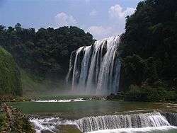 Huangguoshu Waterfall, the largest in China | |
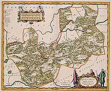
.svg.png) Map showing the location of Guizhou Province | |
| Coordinates: 26°50′N 106°50′E | |
| Named for | Gui - Gui Mountains zhou (prefecture) |
| Capital (and largest city) | Guiyang |
| Divisions | 9 prefectures, 88 counties, 1539 townships |
| Government | |
| • Secretary | Sun Zhigang |
| • Governor | Shen Yiqin |
| Area | |
| • Total | 176,167 km2 (68,018 sq mi) |
| Area rank | 16th |
| Highest elevation | 2,900 m (9,500 ft) |
| Population (2010)[2] | |
| • Total | 34,746,468 |
| • Rank | 19th |
| • Density | 200/km2 (510/sq mi) |
| • Density rank | 18th |
| Demographics | |
| • Ethnic composition | Han - 62% Miao - 12% Buyei - 8% Dong - 5% Tujia - 4% Yi - 2% Undistinguished - 2% Gelao - 2% Sui - 1% |
| • Languages and dialects | Southwestern Mandarin |
| ISO 3166 code | CN-GZ |
| GDP (2017 [3]) | CNY 1.35 trillion USD 200.55 billion (25th) |
| • per capita | CNY 37,956 USD 5,622 (29st) |
| HDI (2018) | medium · 29th |
| Website | http://www.gzgov.gov.cn (Simplified Chinese) |
| Guizhou | |||||||||||||||||||||||||||||||||
|---|---|---|---|---|---|---|---|---|---|---|---|---|---|---|---|---|---|---|---|---|---|---|---|---|---|---|---|---|---|---|---|---|---|
.svg.png) "Guizhou" in Simplified (top) and Traditional (bottom) Chinese characters | |||||||||||||||||||||||||||||||||
| Simplified Chinese | 贵州 | ||||||||||||||||||||||||||||||||
| Traditional Chinese | 貴州 | ||||||||||||||||||||||||||||||||
| Hanyu Pinyin | Guìzhōu | ||||||||||||||||||||||||||||||||
| Postal | Kweichow | ||||||||||||||||||||||||||||||||
| |||||||||||||||||||||||||||||||||
Dian Kingdom, which inhabited the present-day area of Guizhou, was annexed by the Han dynasty in 106 BC.[5] Guizhou was formally made a province in 1413 during the Ming dynasty. After the overthrow of the Qing in 1911 and following the Chinese Civil War, the Communist Party of China took refuge in Guizhou during the Long March between 1934 and 1935.[6] After the establishment of the People's Republic of China, Mao Zedong promoted the relocation of heavy industry into inland provinces such as Guizhou, to better protect them from Soviet and American attacks.
Compared to other provinces of China, Guizhou has not benefited substantially from the Chinese economic reform. Guizhou is rich in natural cultural and environmental resources. Its natural industry includes timber and forestry, and the energy and mining industries constitute an important part of its economy. Notwithstanding, Guizhou is considered a relatively poor and economically undeveloped province, with the third-lowest GDP per capita in China, ahead of Gansu neighboring Yunnan. However, it is also one of China's fastest-growing economies.[7] The Chinese government is looking to develop Guizhou as a data hub.[8][9]
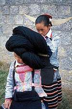
Guizhou is a mountainous province, although its higher altitudes are in the west and centre. It lies at the eastern end of the Yungui Plateau. Demographically, it is one of China's most diverse provinces. Minority groups account for more than 37% of the population, including sizable populations of the Miao, Bouyei, Dong, Tujia and Yi peoples, who speak languages distinct from Chinese. The main language spoken in Guizhou is Southwestern Mandarin, a variety of Mandarin.
Name
The area was first organized as an administrative region of a Chinese empire under the Tang, when it was named Juzhou (矩州), pronounced Kjú-jyuw in the Middle Chinese of the period.[10] During the Mongol-led Yuan dynasty, the character 矩 (ju, "carpenter's square") was changed to the more refined 貴 (gui, "precious or expensive").[10] The region formally became a province in 1413, with an eponymous capital then also called "Guizhou" but now known as Guiyang.[10] Another single-character abbreviation is "黔" (pinyin: Qián).
History
Evidence of settlement by humans during the Middle Palaeolithic is indicated by stone artefacts, including Levallois pieces, found during archaeological excavations at Guanyindong Cave. These artefacts have been dated to approximately 170,000–80,000 years ago using optically stimulated luminescence methods.[11]
From around 1046 BCE to the emergence of the State of Qin, northwest Guizhou was part of the State of Shu.[6] During the Warring States period, the Chinese state of Chu conquered the area, and control later passed to the Dian Kingdom. During the Chinese Han Dynasty (206 BCE–220 CE), to which the Dian was tributary, Guizhou was home to the Yelang collection of tribes, which largely governed themselves before the Han consolidated control in the southwest and established the Lingnan province.[6] During the Three Kingdoms period, parts of Guizhou were governed by the Shu Han state based in Sichuan, followed by Cao Wei (220–265) and the Jin Dynasty (265–420).[6]
During the 8th and 9th centuries in the Tang dynasty, Chinese soldiers moved into Guizhou (Kweichow) and married native women. Their descendants are known as Lǎohànrén (老汉人), in contrast to new Chinese who populated Guizhou at later times. They still speak an archaic dialect.[12] Many immigrants to Guizhou were descended from these soldiers in garrisons who married these pre-Chinese women.[13]
Kublai Khan and Möngke Khan conquered the Chinese southwest in the process of defeating the Song during the Mongol invasion of China, and the newly established Yuan dynasty (1279–1368) saw the importation of Chinese Muslim administrators and settlers from Bukhara in Central Asia.[6]
It was during the following Ming dynasty, which was once again led by Han Chinese, that Guizhou was formally made a province in 1413. The Ming established many garrisons in Guizhou from which to pacify the Yao and Miao minorities during the Miao Rebellions.[6] Chinese-style agriculture flourished with the expertise of farmers from Sichuan, Hunan and its surrounding provinces into Guizhou. Wu Sangui was responsible for the ousting the Ming in Guizhou and Yunnan during the Manchu conquest of China. During the governorship-general of the Qing Dynasty's nobleman Ortai, the tusi system of indirect governance of the southwest was abolished, prompting rebellions from disenfranchised chieftains and the further centralization of government. After the Second Opium War, criminal triads set up shop in Guangxi and Guizhou to sell British opium. For a time, Taiping Rebels took control of Guizhou, but they were ultimately suppressed by the Qing.[6] Concurrently, Han Chinese soldiers moved into the Taijiang region of Guizhou, married Miao women, and their children were brought up as Miao.[14][15]
More unsuccessful Miao rebellions occurred during the Qing, in 1735, from 1795–1806[16] and from 1854–1873.[17] After the overthrow of the Qing in 1911 and following Chinese Civil War, the Communists took refuge in Guizhou during the Long March (1934–1935).[6] While the province was formally ruled by the Guomindang warlord Wang Jialie, the Zunyi Conference in Guizhou established Mao Zedong as the leader of the Communist Party. As the Second Sino-Japanese War pushed China's Nationalist Government to its southwest base of Chongqing, transportation infrastructure improved as Guizhou was linked with the Burma Road.[18] After the end of the War, a 1949 Revolution swept Mao into power, who promoted the relocation of heavy industry into inland provinces such as Guizhou, to better protect them from Soviet and American attacks. After the Chinese economic reform began in 1978, geographical factors led Guizhou to become the poorest province in China, with a GDP growth average of 9 percent from 1978–1993.[18]
Geography
Guizhou is a mountainous province, although its higher altitudes are in the west and centre. It lies at the eastern end of the Yungui Plateau.[19] At 2,900 m (9,514 ft) meters above sea level, Jiucaiping is Guizhou's highest point.[20]
Guizhou has a humid subtropical climate. There are few seasonal changes. Its annual average temperature is roughly 10 to 20 °C, with January temperatures ranging from 1 to 10 °C and July temperatures ranging from 17 to 28 °C.
Like in China's other southwest provinces, rural areas of Guizhou suffered severe drought during spring 2010. One of China's poorest provinces, Guizhou is experiencing serious environmental problems, such as desertification and persistent water shortages. On 3–5 April 2010, China's Premier Wen Jiabao went on a three-day inspection tour in the southwest drought-affected province of Guizhou, where he met villagers and called on agricultural scientists to develop drought-resistant technologies for the area.[21]
Biodiversity
The border mountains of Guizhou, Guangxi, and Hunan have been identified as one of the eight plant diversity hotspots in China. The main ecosystem types include evergreen broad-leaved forest, coniferous and broad-leaved mixed forest, and montane elfin forest. Plant species endemic to this region include Abies ziyuanensis, Cathaya argyrophylla, and Keteleeria pubescens.[22] In broad terms, the Yunnan-Guizhou Plateau is one of the vertebrate diversity hotspots of China. At the level of counties, Xingyi is one of nine Chinese vertebrate diversity (excluding birds) hotspots.[23] Animals only known from Guizhou include Leishan moustache toad, Kuankuoshui salamander, Shuicheng salamander, Guizhou salamander, and Zhijin warty newt.
Caohai Lake with its surroundings is a wetland that is an important overwintering site for many birds. It is a National Nature Reserve and an Important Bird Area identified by BirdLife International.[24]
Politics
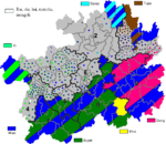
Administrative divisions
Guizhou is divided into nine prefecture-level divisions: six prefecture-level cities and three autonomous prefectures:
| Administrative divisions of Guizhou | ||||||||||||
|---|---|---|---|---|---|---|---|---|---|---|---|---|
 Liupanshui
Zunyi
Anshun
Bijie
Tongren
Qianxinan
Aut. Prefecture Qiandongnan
Aut. Prefecture Qiannan
Aut. Prefecture | ||||||||||||
| Division code[25] | Division | Area in km2[26] | Population 2010[27] | Seat | Divisions[28] | |||||||
| Districts* | Counties | Aut. counties | CL cities | |||||||||
| 520000 | Guizhou Province | 176167.00 | 34,746,468 | Guiyang city | 16 | 52 | 11 | 9 | ||||
| 520100 | Guiyang city | 8,046.67 | 4,324,561 | Guanshanhu District | 6 | 3 | 1 | |||||
| 520200 | Liupanshui city | 9,965.37 | 2,851,180 | Zhongshan District | 2 | 1 | 1 | |||||
| 520300 | Zunyi city | 30,780.73 | 6,127,009 | Huichuan District | 3 | 7 | 2 | 2 | ||||
| 520400 | Anshun city | 9,253.06 | 2,297,339 | Xixiu District | 2 | 1 | 3 | |||||
| 520500 | Bijie city | 26,844.45 | 6,536,370 | Qixingguan District | 1 | 6 | 1 | |||||
| 520600 | Tongren city | 18,006.41 | 3,092,365 | Bijiang District | 2 | 4 | 4 | |||||
| 522300 | Qianxinan Aut. Prefecture | 16,785.93 | 2,805,857 | Xingyi city | 6 | 2 | ||||||
| 522600 | Qiandongnan Aut. Prefecture | 30,278.06 | 3,480,626 | Kaili city | 15 | 1 | ||||||
| 522700 | Qiannan Aut. Prefecture | 26,191.78 | 3,231,161 | Duyun city | 9 | 1 | 2 | |||||
| * - including Special district | ||||||||||||
| Administrative divisions in Chinese and varieties of romanizations | ||||
|---|---|---|---|---|
| English | Chinese | Pinyin | ||
| Guizhou Province | 贵州省 | Guìzhōu Shěng | ||
| Guiyang city | 贵阳市 | Guìyáng Shì | ||
| Liupanshui city | 六盘水市 | Liùpánshuǐ Shì | ||
| Zunyi city | 遵义市 | Zūnyì Shì | ||
| Anshun city | 安顺市 | Ānshùn Shì | ||
| Bijie city | 毕节市 | Bìjié Shì | ||
| Tongren city | 铜仁市 | Tóngrén Shì | ||
| Qianxinan Aut. Prefecture | 黔西南自治州 | Qiánxīnán Zzhōu | ||
| Qiandongnan Aut. Prefecture | 黔东南自治州 | Qiándōngnán Zzhōu | ||
| Qiannan Aut. Prefecture | 黔南自治州 | Qiánnán Zhōu | ||
The nine Prefecture of Guizhou are subdivided into 88 county-level divisions (14 districts, 7 county-level cities, 55 counties, and 11 autonomous counties,1 special district).
Urban areas
| Population by urban areas of prefecture & county cities | |||||
|---|---|---|---|---|---|
| # | City | Urban area[29] | District area[29] | City proper[29] | Census date |
| 1 | Guiyang | 2,520,061 | 3,034,750 | 4,322,611 | 2010-11-01 |
| 2 | Zunyi[lower-alpha 1] | 715,148 | 1,094,871 | 6,127,082 | 2010-11-01 |
| (2) | Zunyi (new district)[lower-alpha 1] | 280,163 | 942,904 | see Zunyi | 2010-11-01 |
| 3 | Liupanshui | 491,438 | 616,210 | 2,851,332 | 2010-11-01 |
| 4 | Bijie[lower-alpha 2] | 421,342 | 1,137,383 | 6,537,498 | 2010-11-01 |
| 5 | Anshun[lower-alpha 3] | 358,920 | 765,399 | 2,297,612 | 2010-11-01 |
| (5) | Anshun (new district)[lower-alpha 3] | 95,601 | 297,990 | see Anshun | 2010-11-01 |
| 6 | Xingyi | 335,243 | 783,120 | part of Qianxinan Prefecture | 2010-11-01 |
| 7 | Kaili | 274,922 | 479,011 | part of Qiandongnan Prefecture | 2010-11-01 |
| 8 | Tongren[lower-alpha 4] | 218,542 | 409,488 | 3,093,204 | 2010-11-01 |
| 9 | Duyun | 217,091 | 443,721 | part of Qiannan Prefecture | 2010-11-01 |
| (10) | Panzhou[lower-alpha 5] | 176,237 | 103,5345 | see Liupanshui | 2010-11-01 |
| 11 | Renhuai | 171,005 | 546,477 | see Zunyi | 2010-11-01 |
| 12 | Qingzhen | 166916 | 467790 | see Guiyang | 2010-11-01 |
| 13 | Fuquan | 158,515 | 283,904 | part of Qiannan Prefecture | 2010-11-01 |
| (14) | Xingren[lower-alpha 6] | 113043 | 417,919 | part of Qianxinan Prefecture | 2010-11-01 |
| 15 | Chishui | 80,884 | 237,052 | see Zunyi | 2010-11-01 |
- New district established after census: Bozhou (Zunyi County). The new district not included in the urban area & district area count of the pre-expanded city.
- Bijie Prefecture is currently known as Bijie PLC after census; Bijie CLC is currently known as Qixingguan after census.
- New district established after census: Pingba (Pingba County). The new district not included in the urban area & district area count of the pre-expanded city.
- Tongren Prefecture is currently known as Tongren PLC after census; Tongren CLC & Wanshan SD is currently known as Bijiang & Wanshan after census.
- Panxian County is currently known as Panzhou CLC after census.
- Xingren County is currently known as Xingren CLC after census.
Economy

As of the mid-19th century, Guizhou exported mercury, gold, iron, lead, tobacco, incense and drugs.[30]
Guizhou is a relatively poor and economically undeveloped province, but rich in natural, cultural and environmental resources. Its nominal GDP for 2012 was 680.22 billion yuan (US$107.758 billion). Its per capita GDP of RMB 19,566 (US$3,100) is the third lowest in China.
Its natural industry includes timber and forestry.[31] Guizhou is also the third largest producer of tobacco in China, and home to the well-known brand Guizhou Tobacco.[32] Other important industries in the province include energy (electricity generation) - a large portion of which is exported to Guangdong and other provinces[32] - and mining, especially in coal, limestone, arsenic, gypsum, and oil shale.[31] Guizhou's total output of coal was 118 million tons in 2008, a 7% growth from the previous year.[33] Guizhou's export of power to Guangdong equaled 12% of Guangdong's total power consumption. Over the next 5 years Guizhou hopes to increase this by as much as 50%.[34]
Transportation
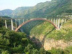
In 2017, Sun Zhigang, the governor of Guizhou, has announced the plans to build 10,000 kilometers of highways, 17 airports, 600 km (370 mi) of inland waterways, and 4,000 km (2,500 mi) of high-speed rail lines in three years, in an effort to boost the tourism in the province.[36]
Rail
Guizhou's rail network consists primarily of a cross formed by the Sichuan–Guizhou, Guangxi–Guizhou and Shanghai–Kunming Railways, which intersect at the provincial capital, Guiyang, near the center of the province. The Liupanshui–Baiguo, Pan County West and Weishe–Hongguo Railways form a rail corridor along Guizhou's western border with Yunnan. This corridor connects the Neijiang–Kunming Railway, which dips into northwestern Guizhou at Weining, with the Nanning–Kunming Railway, which skirts the southwestern corner of Guizhou at Xingyi.
As of 2018, Shanghai–Kunming high-speed railway and Guiyang–Guangzhou high-speed railway is under operational.Chengdu–Guiyang high-speed railway is under construction.
Demographics
| Historical population | ||
|---|---|---|
| Year | Pop. | ±% p.a. |
| 1912[37] | 9,665,000 | — |
| 1928[38] | 14,746,000 | +2.68% |
| 1936-37[39] | 9,919,000 | −4.84% |
| 1947[40] | 10,174,000 | +0.23% |
| 1954[41] | 15,037,310 | +5.74% |
| 1964[42] | 17,140,521 | +1.32% |
| 1982[43] | 28,552,997 | +2.88% |
| 1990[44] | 32,391,066 | +1.59% |
| 2000[45] | 35,247,695 | +0.85% |
| 2010[46] | 34,746,468 | −0.14% |
In 1832, the population was estimated at five million.[30]
Guizhou is demographically one of China's most diverse provinces. Minority groups account for more than 37% of the population and they include Miao (including Gha-Mu and A-Hmao), Yao, Yi, Qiang, Dong, Zhuang, Bouyei, Bai, Tujia, Gelao and Sui. 55.5% of the province area is designated as autonomous regions for ethnic minorities. Guizhou is the province with the highest fertility rate in China, standing at 2.19 (Urban-1.31, Rural-2.42).[47]
Religion
The predominant religions in Guizhou are Chinese folk religions, Taoist traditions and Chinese Buddhism. According to surveys conducted in 2007 and 2009, 31.18% of the population believes and is involved in ancestor veneration, while 0.99% of the population identifies as Christian, decreasing from 1.13% in 2004.[48]
The reports did not give figures for other types of religion; 67.83% of the population may be either irreligious or involved in worship of nature deities, Buddhism, Confucianism, Taoism, folk religious sects, and small minorities of Muslims. There are significant ethnic minority populations (the Miao and the Buyei) who traditionally follow their autochthonous religions.
Cuisine
Guizhou is the home of the well-known Chinese liquor Moutai.[49]
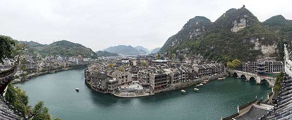
Tourism
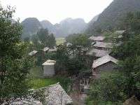
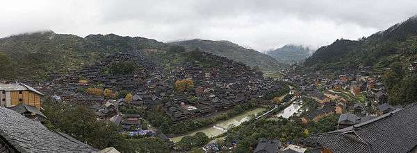
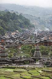
The province has many covered bridges, called Wind and Rain Bridges. These were built by the Dong people.
The southeastern corner of the province is known for its unique Dong minority culture. Towns such as Rongjiang, Liping, Diping and Zhaoxing are scattered amongst the hills along the border with Guangxi.
Heritage-based tourism
The World Bank "Strategic Environmental Assessment Study: Tourism Development in the Province of Guizhou, China" (May 25, 2007)[50] points to three different forms of tourism that should be fostered and developed in Guizhou, China: Nature-based, Heritage-based and Rural Tourism. Heritage-based tourism provides ethnic minority groups with an opportunity to preserve their unique heritage while still making a living.
Colleges and universities
- Guizhou University (Guiyang)
- Guizhou Normal University (Guiyang)
- Guiyang Medical University (Guiyang)
- Guizhou Nationalities University (Guiyang)
- Guizhou Institute of Technology (Guiyang)
- Zunyi Medical College (Zunyi)
- Moutai University (Zunyi)
Media
- Guizhou Daily
Notable people from Guizhou
- Shi Jinmo (1881-1969), founder of medical colleges
See also
- Major national historical and cultural sites in Guizhou
Notes
- The data was collected by the Chinese General Social Survey (CGSS) of 2009 and by the Chinese Spiritual Life Survey (CSLS) of 2007, reported and assembled by Xiuhua Wang (2015)[48] in order to confront the proportion of people identifying with two similar social structures: ① Christian churches, and ② the traditional Chinese religion of the lineage (i. e. people believing and worshipping ancestral deities often organised into lineage "churches" and ancestral shrines). Data for other religions with a significant presence in China (Buddhism, Confucianism, deity worships, Taoism, folk religious sects, Islam, religions practiced by ethnic minorities, et. al.) was not reported by Wang.
- This may include:
- Buddhists;
- Confucians;
- Deity worshippers;
- Taoists;
- Members of folk religious sects;
- Small minorities of Muslims;
- Indigenous religions of the ethnic minorities;
- And people not bounded to, nor practicing any, institutional or diffuse religion.
References
Citations
- "Doing Business in China - Survey". Ministry Of Commerce - People's Republic Of China. Retrieved 5 August 2013.
- "Communiqué of the National Bureau of Statistics of People's Republic of China on Major Figures of the 2010 Population Census [1] (No. 2)". National Bureau of Statistics of China. 29 April 2011. Archived from the original on 27 July 2013. Retrieved 4 August 2013.
- 贵州省2017年国民经济和社会发展统计公报 [Statistical Communiqué of Guizhou Province on the 2017 National Economic and Social Development] (in Chinese). Statistical Bureau of Guizhou. 2018-04-04. Retrieved 2018-06-22.
- "Sub-national HDI - Subnational HDI - Global Data Lab". globaldatalab.org. Retrieved 2020-04-17.
- Shennan, Stephen (1989). Archaeological approaches to cultural identity (illustrated ed.). Unwin Hyman. ISBN 0-04-445016-8.
- Maygew, Bradley; Miller, Korina; English, Alex (2002). "Facts about South-West China - History". South-West China (2 ed.). Lonely Planet. pp. 16–20, 24.
- 董志成. "Guizhou takes the green road to growth - Chinadaily.com.cn". www.chinadaily.com.cn. Retrieved 2019-06-12.
- "How the trade war could impact China's big data hub Guizhou". EJ Insight. 2019-05-14. Retrieved 2019-06-12.
- "Huawei, Guizhou to deepen partnership in big data area--China Economic Net". en.ce.cn. Retrieved 2019-06-12.
- Wilkinson (2012), p. 233.
- Hu, Yue; Marwick, Ben; Zhang, Jia-Fu; Rui, Xue; Hou, Ya-Mei; Yue, Jian-Ping; Chen, Wen-Rong; Huang, Wei-Wen; Li, Bo (19 November 2018). "Late Middle Pleistocene Levallois stone-tool technology in southwest China". Nature. 565 (7737): 82–85. doi:10.1038/s41586-018-0710-1. PMID 30455423.
- Scottish Geographical Society (1929). Scottish geographical magazine, Volumes 45-46. Royal Scottish Geographical Society. p. 70. Retrieved 2010-06-28.
- Margaret Portia Mickey (1947). The Cowrie Shell Miao of Kweichow, Volume 32, Issue 1. The Museum. p. 6. Retrieved 2010-06-28.
- Contributions to Southeast Asian ethnography, Issue 7. Board of Editors, Contributions to Southeast Asian Ethnography. 1988. p. 99. Retrieved 2010-06-28.
- Dan Jin; Xueliang Ma; Mark Bender (2006). Butterfly mother: Miao (Hmong) creation epics from Guizhou, China. Hackett Publishing. p. xvii. ISBN 0-87220-849-4. Retrieved 2010-06-28.
- Elleman, Bruce A. (2001). "The Miao Revolt (1795–1806)". Modern Chinese Warfare, 1795-1989. London: Routledge. pp. 7–8. ISBN 978-0-415-21474-2.
- Robert D. Jenks (1994). Insurgency and Social Disorder in Guizhou: The "Miao" Rebellion, 1854-1873. Honolulu: University of Hawaii Press. p. 2. ISBN 0-8248-1589-0.
- Hutchings, Graham (2003). "Guizhou Province". Modern China: A Guide to a Century of Change. Harvard University Press. pp. 176–177.
- "Guizhou Province". ChinaToday.com. Retrieved 29 February 2016.
- 贵州最高的山——韭菜坪,千年难得一见的美景. Sina.
韭菜坪海拔2900米,是贵州最高的山峰,它位于六盘水市与赫章县的交界处,因每到8,9月份山上开满野生韭菜花故得其名。
- "China's premier concerned about drought in SW China". Xinhua. 2010-04-05. Retrieved 2008-09-17.
- Zhang, Y. B.; Ma, K. P. (2008). "Geographic distribution patterns and status assessment of threatened plants in China". Biodiversity and Conservation. 17 (7): 1783–1798. doi:10.1007/s10531-008-9384-6.
- Chen, Yang; An-Ping Chen; Jing-Yun Fang (2002). "Geographical distribution patterns of endangered fishes, amphibians, reptiles and mammals and their hotspots in China: a study based on "China Red Data Book of Endangered Animals"". Biodiversity Science. 10 (4): 359–368.
- BirdLife International (2013). "Important Bird Areas factsheet: Cao Hai Nature Reserve". Retrieved 24 February 2013.
- 中华人民共和国县以上行政区划代码 (in Chinese). Ministry of Civil Affairs.
- Shenzhen Bureau of Statistics. Archived copy 《深圳统计年鉴2014》 (in Chinese). China Statistics Print. Archived from the original on 2015-05-12. Retrieved 2015-05-29.CS1 maint: archived copy as title (link)
- Census Office of the State Council of the People's Republic of China; Population and Employment Statistics Division of the National Bureau of Statistics of the People's Republic of China (2012). 中国2010人口普查分乡、镇、街道资料 (1 ed.). Beijing: China Statistics Print. ISBN 978-7-5037-6660-2.
- Ministry of Civil Affairs (August 2014). 《中国民政统计年鉴2014》 (in Chinese). China Statistics Print. ISBN 978-7-5037-7130-9.
- 国务院人口普查办公室、国家统计局人口和社会科技统计司编 (2012). 中国2010年人口普查分县资料. Beijing: China Statistics Print. ISBN 978-7-5037-6659-6.
- Roberts, Edmund (1837). Embassy to the Eastern Courts of Cochin-China, Siam, and Muscat. New York: Harper & Brothers. p. 123.
- "Market Profiles on Chinese Cities and Provinces : Guizhou Province". Hong Kong Trade Development Council (HKTD)/Guizhou Statistical Yearbook 2008. January 2009. Retrieved 2010-11-27.
- http://thechinaperspective.com/topics/province/guizhou-province/
- "Coal output in SW China province tops 100 mln tons". People's Daily Online. 2005-12-24. Retrieved 2008-07-06.
- The China Perspective | Guizhou Economic Facts and Data
- "Guiyang Eco&Tech Development Zone". Business in China. china.com. 17 September 2004. Retrieved 10 February 2013.
- "Guizhou, One of China's Underdeveloped Provinces, Vows to Build 10,000 km of Highway, More Than All of France". www.prnewswire.com. Retrieved 2018-08-27.
- 1912年中国人口. Retrieved 6 March 2014.
- 1928年中国人口. Retrieved 6 March 2014.
- 1936-37年中国人口. Retrieved 6 March 2014.
- 1947年全国人口. Retrieved 6 March 2014.
- 中华人民共和国国家统计局关于第一次全国人口调查登记结果的公报. National Bureau of Statistics of China. Archived from the original on 2009-08-05.
- 第二次全国人口普查结果的几项主要统计数字. National Bureau of Statistics of China. Archived from the original on 2012-09-14.
- 中华人民共和国国家统计局关于一九八二年人口普查主要数字的公报. National Bureau of Statistics of China. Archived from the original on 2012-05-10.
- 中华人民共和国国家统计局关于一九九〇年人口普查主要数据的公报. National Bureau of Statistics of China. Archived from the original on 2012-06-19.
- 现将2000年第五次全国人口普查快速汇总的人口地区分布数据公布如下. National Bureau of Statistics of China. Archived from the original on 2012-08-29.
- "Communiqué of the National Bureau of Statistics of People's Republic of China on Major Figures of the 2010 Population Census". National Bureau of Statistics of China. Archived from the original on 2013-07-27.
- Heather Kathleen Mary Terrell (May 2005). "Fertility in China in 2000 : A County Level Analysis (thesis, 140 p.)" (PDF). Texas A & M University. Retrieved 2010-11-27.
- China General Social Survey 2009, Chinese Spiritual Life Survey (CSLS) 2007. Report by: Xiuhua Wang (2015, p. 15) Archived 2015-09-25 at the Wayback Machine
- "Maotai Remains Short in Supply in 2008". CRIEnglish.com. 8 January 2008. Retrieved 27 March 2012.
- "Strategic Environmental Assessment Study: Tourism Development in the Province of Guizhou, China" (PDF). World Bank. May 25, 2007. (needs a direct cite)
Works cited
- Wilkinson, Endymion (2012). Chinese History: A New Manual. Harvard-Yenching Institute Monograph Series 84. Cambridge, MA: Harvard-Yenching Institute; Harvard University Asia Center. ISBN 978-0-674-06715-8.CS1 maint: ref=harv (link)
External links
| Wikimedia Commons has media related to Guizhou. |
| Wikivoyage has a travel guide for Guizhou. |
- Guizhou government website (in Chinese)
- Guiyang Government website
- Township level administrative map of Guizhou
| Provinces | ||
|---|---|---|
| Autonomous regions |
| |
| Municipalities | ||
| Special administrative regions | ||
| Other |
| |
Note: Taiwan is claimed by the People's Republic of China but administered by the Republic of China (see Political status of Taiwan). | ||
Guizhou topics | |
|---|---|
Guiyang (capital) | |
| General | |
| Geography |
|
| Education |
|
| Culture |
|
| Visitor attractions |
|
| |
| Authority control |
|
|---|