Ellesmere Island
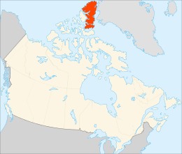
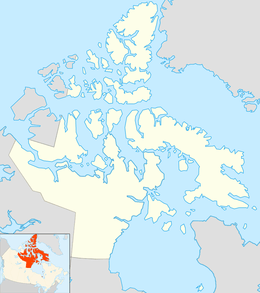
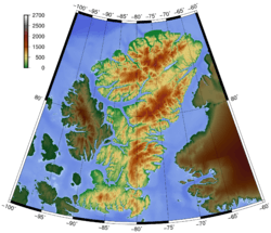
Ellesmere Island (Inuktitut: Umingmak Nuna, meaning "land of muskoxen"; French: Île d'Ellesmere)[1] is part of the Qikiqtaaluk Region in the Canadian territory of Nunavut. Lying within the Arctic Archipelago, it is considered part of the Queen Elizabeth Islands, with Cape Columbia being the most northerly point of land in Canada. It comprises an area of 196,235 km2 (75,767 sq mi) and the total length of the island is 830 km (520 mi), making it the world's tenth largest island and Canada's third largest island.[2] The Arctic Cordillera mountain system covers much of Ellesmere Island, making it the most mountainous in the Arctic Archipelago. The Arctic willow is the only woody species to grow on Ellesmere Island.[3]
| Native name: Umingmak Nuna | |
|---|---|
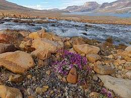 Tundra in Quttinirpaaq National Park | |
 | |
 Ellesmere Island 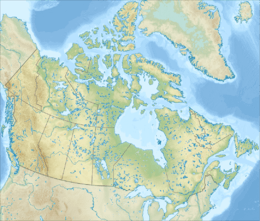 Ellesmere Island | |
| Geography | |
| Location | Northern Canada |
| Coordinates | 79°50′N 78°00′W |
| Archipelago | Queen Elizabeth Islands |
| Area | 196,235 km2 (75,767 sq mi) |
| Area rank | 10th |
| Length | 830 km (516 mi) |
| Width | 645 km (400.8 mi) |
| Highest elevation | 2,616 m (8,583 ft) |
| Highest point | Barbeau Peak |
| Administration | |
Canada | |
| Territory | Nunavut |
| Largest settlement | Grise Fiord (pop. 129) |
| Demographics | |
| Population | 191 (2016) |
| Pop. density | 0.00097/km2 (0.00251/sq mi) |
| Area code(s) | 867 |
History
The first human inhabitants of Ellesmere Island were small bands drawn to the area for Peary caribou, muskox, and marine mammal hunting about 2000–1000 BCE.[4]
As was the case for the Dorset (or Paleo-Eskimo) hunters and the pioneering Neoeskimos, the post-Ruin Island and Late Thule culture Inuit used the Bache Peninsula region extensively both summer and winter until environmental, ecological, and possibly social circumstances caused the area to be abandoned. It was the last region in the Canadian High Arctic to be depopulated during the Little Ice Age, attesting to its general economic importance as part of the Smith Sound culture sphere of which it was occasionally a part and sometimes the principal settlement component.[5]
Vikings from the Greenland colonies reached Ellesmere Island, Skraeling Island, and Ruin Island during hunting expeditions and trading with the Inuit groups.[5] Unusual structures on Bache Peninsula may be the remains of a late-period Dorset stone longhouse.[6]
The first European to sight the island after the height of the Little Ice Age was William Baffin in 1616. Ellesmere Island was named in 1852 by Edward Inglefield's expedition after Francis Egerton, 1st Earl of Ellesmere.[7] The US expedition led by Adolphus Greely in 1881 crossed the island from east to west,[1]:631 establishing Fort Conger in the northern part of the island. The Greely expedition found fossil forests on Ellesmere Island in the late 1880s. Stenkul Fiord was first explored in 1902 by Per Schei, a member of Otto Sverdrup's 2nd Norwegian Polar Expedition.
The Ellesmere Ice Shelf was documented by the British Arctic Expedition of 1875–76, in which Lieutenant Pelham Aldrich's party went from Cape Sheridan (82°28′N 61°30′W) west to Cape Alert (82°16′N 85°33′W), including the Ward Hunt Ice Shelf. In 1906 Robert Peary led an expedition in northern Ellesmere Island, from Cape Sheridan along the coast to the western side of Nansen Sound (93°W). During Peary's expedition, the ice shelf was continuous; it has since been estimated to have covered 8,900 km2 (3,400 sq mi).[8]
Geography

Ellesmere Island is separated to the east by Nares Strait from Greenland, to the west by Eureka Sound and Nansen Sound from Axel Heiberg Island, and to the south by Jones Sound and Cardigan Strait from Devon Island.
Ellesmere Island contains Canada's northernmost point, Cape Columbia, at 83°6′41″N.
Protected areas
More than one-fifth of the island is protected as Quttinirpaaq National Park (formerly Ellesmere Island National Park Reserve), which includes seven fjords and a variety of glaciers, as well as Lake Hazen, North America's largest lake north of the Arctic Circle. Barbeau Peak, the highest mountain in Nunavut (2,616 m or 8,583 ft) is located in the British Empire Range on Ellesmere Island. The most northern mountain range in the world, the Challenger Mountains, is located in the northeast region of the island. The northern lobe of the island is called Grant Land.
In July 2007, a study noted the disappearance of habitat for waterfowl, invertebrates, and algae on Ellesmere Island. According to John Smol of Queen's University in Kingston, Ontario, and Marianne S. V. Douglas of the University of Alberta in Edmonton, warming conditions and evaporation have caused low water levels and changes in the chemistry of ponds and wetlands in the area. The researchers noted that "In the 1980s they often needed to wear hip waders to make their way to the ponds...while by 2006 the same areas were dry enough to burn."[9]
Glaciers and ice caps
Large portions of Ellesmere Island are covered with glaciers and ice, with Manson Icefield (6,200 km2 or 2,400 sq mi) and Sydkap (3,700 km2 or 1,400 sq mi) in the south; Prince of Wales Icefield (20,700 km2 or 8,000 sq mi) and Agassiz Ice Cap (21,500 km2 or 8,300 sq mi) along the central-east side of the island, and the Northern Ellesmere icefields (24,400 km2 or 9,400 sq mi).[10]
The northwest coast of Ellesmere Island was covered by a massive, 500 km (310 mi) long ice shelf until the 20th century. The Ellesmere Ice Shelf shrank by 90 percent in the 20th century due to warming trends in the Arctic, particularly in the 1930s and 1940s, a period when the largest ice islands (the 200 sq mi (520 km2) T1 and the 300 sq mi (780 km2) T2 ice islands) were formed leaving the separate Alfred Ernest, Ayles, Milne, Ward Hunt, and Markham Ice Shelves.[11] A 1986 survey of Canadian ice shelves found that 48 km2 (19 sq mi) or 3.3 km3 (0.79 cu mi) of ice calved from the Milne and Ayles ice shelves between 1959 and 1974.[8] The Ward Hunt Ice Shelf, the largest remaining section of thick (>10 m, >30 ft) landfast sea ice along the northern coastline of Ellesmere Island, lost 600 km (370 mi) of ice in a massive calving in 1961–1962.[12] It further decreased by 27% in thickness (13 m or 43 ft) between 1967 and 1999.[13]
.jpg)
The breakup of the Ellesmere Ice Shelves has continued in the 21st century: the Ward Ice Shelf experienced a major breakup during the summer of 2002;[14] the Ayles Ice Shelf calved entirely on August 13, 2005; the largest breakoff of the ice shelf in 25 years, it may pose a threat to the oil industry in the Beaufort Sea. The piece is 66 km2 (25 sq mi).[15] In April 2008, it was discovered that the Ward Hunt shelf was fractured, with dozens of deep, multi-faceted cracks[16] and in September 2008 the Markham shelf (50 km2 or 19 sq mi) completely broke off to become floating sea ice.[17]
A study published 2018 by White and Copland measured an areal reduction of 5.9% in 1773 glaciers in Northern Ellesmere island in the 16-year period 1999-2015 based on satellite data. In the same period 19 out of 27 ice tongues disintegrated to their grounding lines and ice shelves suffered a 42% loss in surface area.[18]
Paleontology
Schei and later Nathorst[19] described the Paleocene-Eocene (ca. 55 Ma) fossil forest in the Stenkul Fiord sediments. The Stenkul Fiord site represents a series of deltaic swamp and floodplain forests.[20] The trees stood for at least 400 years. Individual stumps and stems of >1 m (>3 ft) diameter were abundant, and are identified as Metasequoia and possibly Glyptostrobus. Well preserved Pliocene peats containing abundant vertebrate and plant macrofossils characteristic of a boreal forest have been reported from Strathcona Fiord.[21][22]
In 2006, University of Chicago paleontologist Neil Shubin and Academy of Natural Sciences paleontologist Ted Daeschler reported the discovery of the fossil of a Paleozoic (ca. 375 Ma) fish, named Tiktaalik roseae, in the former stream beds of Ellesmere Island. The fossil exhibits many characteristics of fish, but also indicates a transitional creature that may be a predecessor of amphibians, reptiles, birds, and mammals, including humans.[23]
In 2011, Jason P. Downs and co-authors described the sarcopterygian Laccognathus embryi from specimens collected from the same locality that Tiktaalik was found.[24]
Insect ecology
Ellesmere Island is noted as being the northernmost occurrence of eusocial insects; specifically, the bumblebee Bombus polaris. There is a second species of bumblebee occurring there, Bombus hyperboreus, which is a parasite in the nests of B. polaris.[25]
While non-eusocial, the Arctic woolly bear moth (Gynaephora groenlandica) can also be found at Ellesmere Island. While this species generally has a 10-year life cycle, its life is known to extend to up to 14 years at both the Alexandra Fiord lowland and Ellesmere Island.[26][27][28]
Earth's magnetism
In 2015, the Earth's geomagnetic north pole was located at approximately 80.37°N 72.62°W, on Ellesmere Island.[29] It is forecast to remain on Ellesmere Island in 2020, shifting to 80.65°N 72.68°W.[30]
Population
In 2016, the population of Ellesmere Island was recorded as 191. There are three settlements on Ellesmere Island: Alert (pop. 62),[31] Eureka (permanent pop. 0, but home to a small temporary population), and Grise Fiord (pop. 129),[32] Politically, it is part of the Qikiqtaaluk Region.
Alert
Canadian Forces Station (CFS) Alert is the northernmost settlement in the world. With the end of the Cold War and the advent of new technologies allowing for remote interpretation of data, the overwintering population has been reduced to 62 civilians and military personnel as of 2016.
Eureka
Eureka (the third northernmost settlement in the world) consists of three areas: Eureka Aerodrome, which includes Fort Eureka (the quarters for military personnel maintaining the island's communications equipment); the Environment Canada Weather Station; and the Polar Environment Atmospheric Research Laboratory (PEARL), formerly the Arctic Stratospheric Ozone (AStrO) Observatory. Eureka has the lowest average annual temperature and least precipitation of any weather station in Canada.
Grise Fiord
Grise Fiord (Inuktitut: ᐊᐅᔪᐃᑦᑐᖅ, romanized: Aujuittuq, lit. "place that never thaws") is an Inuit hamlet that, despite a population of only 129,[31] is the largest community on Ellesmere Island.
Located at the southern tip of Ellesmere Island, Grise Fiord lies 1,160 km (720 mi) north of the Arctic Circle. Grise Fiord is the northernmost civilian settlement in Canada. It is also one of the coldest inhabited places in the world, with an average yearly temperature of −16.5 °C (2.3 °F).
Grise Fiord is cradled by the Arctic Cordillera mountain range.
In popular culture
Ellesmere Island is the setting of much of Melanie McGrath’s The Long Exile: A True Story of Deception and Survival Amongst the Inuit of the Canadian Arctic[33] about the High Arctic relocation, and also of her Edie Kiglatuk mystery series.[34]
In the 2013 American superhero film Man of Steel, Ellesmere Island was the site of a combined U.S.-Canadian scientific expedition to recover an ancient Kryptonian spaceship buried in the glacial ice pack.[35]
The island was the location for the 2014 BBC programme Snow Wolf Family and Me.[36]
See also
- Nansen Sound
- Ellesmere Island Volcanics
- Lomonosov Ridge
- Ledoyom
- Serson Ice Shelf
- Strathcona Fiord
- Borup Fiord Pass
References
- Dick, Lyle (2001). Muskox Land: Ellesmere Island in the Age of Contact. University of Calgary Press. ISBN 978-1-55238-050-5.
- "Top 10 Largest Islands In The World — 100newspaper.xyz" (in Russian). Retrieved January 13, 2020.
- Ed Kemmick (October 25, 2007). "Researcher: Study of poles needed". Billingsgazette.net. Retrieved October 25, 2007.
- Civilization.ca. "Arctic History". Archived from the original on September 23, 2008.
- Schledermann, Peter; McCullough, Karen Margrethe (2003). Late Thule culture developments on the central east coast of Ellesmere Island. Copenhagen, Denmark: Danish Polar Center. ISBN 978-87-90369-64-4.
- Schledermann, Peter (May 1981). "Eskimo and Viking Finds in the High Arctic". National Geographic. 159 (5): 584.
- "Ellesmere Island". The Canadian Encyclopedia Online. Retrieved April 23, 2009.
- Jeffries, Martin O. (March 1986). "Ice Island Calvings and Ice Shelf Changes, Milne Ice Shelf and Ayles Ice Shelf, Ellesmere Island, N.W.T" (PDF). Arctic. 39 (1). doi:10.14430/arctic2039.
- "Northern Canada Ponds Drying Up". ENN. Retrieved February 3, 2014.
- Wolken, G.; Sharp, M.; Wang, L. (2009). "Snow and ice facies variability and ice layer formation on Canadian Arctic ice caps, 1999-2005" (PDF). Journal of Geophysical Research. 114 (F3): 3011. Bibcode:2009JGRF..114.3011W. doi:10.1029/2008JF001173.
- Revkin, Andrew C. (December 30, 2006). "Arctic Ice Shelf Broke Off Canadian Island". New York Times.
- Hattersley-Smith, G (1963). "The Ward Hunt Ice Shelf: recent changes of the ice front". Journal of Glaciology. 4 (34): 415–424. Bibcode:1963JGlac...4..415H. doi:10.1017/S0022143000027830.
- Vincent, WF; Gibson, JAE; Jeffries, MO (2001). "Ice-shelf collapse, climate change, and habitat loss in the Canadian high Arctic" (PDF). Polar Record. 37 (201): 133–142. doi:10.1017/S0032247400026954.
- NASA Earth Observatory (January 20, 2004). "Breakup of the Ward Hunt Ice Shelf".
- "Huge Arctic ice break discovered". BBC News. December 29, 2006. Retrieved February 3, 2014.
- Bob Weber, The Canadian Press (April 12, 2008). "Cracks in Arctic ice shelf signal its demise". The Star. Toronto. Retrieved May 1, 2010.
- BBC News (September 3, 2008). "Major ice-shelf loss for Canada". Retrieved January 3, 2010.
- Adrienne White and Luke Copland, Area change of glaciers across Norther Ellesmere Island, Nunavut, between ~1999 and ~2015, Journal of Glaciology, June 2018
- Nathorst, AG (1915). Tertiare Pflanzenreste Aus Ellesmere-Land. Report of the Second Norwegian Arctic Expedition in the Fram, 1898–1902. 35. The Society of Arts and Sciences of Kristiania.
- Kalkreuth, WD; Riediger, CL; McIntyre, DJ; Richardson, RJH; et al. (1996). "Petrological, palynological and geochemical characteristics of Eureka Sound Group coals (Stenkul Fiord, southern Ellesmere Island, Arctic Canada)". International Journal of Coal Geology. 30 (1–2): 151–182. doi:10.1016/0166-5162(96)00005-5.
- Tedford, RH; Harington, CR (2003). "An Arctic mammal fauna from the Early Pliocene of North America". Nature. 425 (6956): 388–390. Bibcode:2003Natur.425..388T. doi:10.1038/nature01892. PMID 14508486.
- Ballantyne, AP; Greenwood, DR; Sinninghe Damste, JSS; Csank, AZ; et al. (2010). "Significantly warmer Arctic surface temperatures during the Pliocene indicated by multiple independent proxies". Geology. 38 (7): 603–606. Bibcode:2010Geo....38..603B. doi:10.1130/G30815.1.
- Wilford, John Noble (April 6, 2006). "Fossil Called Missing Link From Sea to Land Animals". The New York Times.
- Christine Dell'Amore (September 12, 2011). "Ancient Toothy Fish Found in Arctic—Giant Prowled Rivers". National Geographic. Retrieved September 13, 2011.
- Milliron H.E., Oliver D.R. (1966) Bumblebees from northern Ellesmere Island, with observations on usurpation by Megabombus hyperboreus (Schönh.), Can. Entomol. 98:207–213
- Kukal, Olga (March 24, 1988)."Behavioral Thermoregulation in the Freeze-Tolerant Arctic Caterpillar, Gynaephora groenlandica" (PDF). The Company of Biologists Limited.
- Kukal, Olga (March 24, 1988). "Behavioral Thermoregulation in the Freeze-Tolerant Arctic Caterpillar, Gynaephora groenlandica" (PDF). The Company of Biologists Limited.
- Barrio, Isabel C.; Schmidt, B. Christian; Cannings, Sydney; Hik, David S. (December 2013). "First Records of the Arctic Moth Gynaephora groenlandica (Wocke) South of the Arctic". Arctic. 66 (4): 429–434. doi:10.14430/arctic4329. hdl:10261/142753.
- "Geomagnetism Frequently Asked Questions". National Geophysical Data Center. Retrieved April 28, 2018.
- https://www.ngdc.noaa.gov/geomag/WMM/limit.shtml
- Statistics Canada, Grise Fiord, Hamlet, and Baffin, Unorganized [Census subdivisions], Nunavut (table), Census Profile, 2016 Census of Population, Catalogue № 98‑316‑X2016001 (Ottawa: 2017‑11‑29) [accessed 2019‑10‑28].
- Statistics Canada
- McGrath, MJ (2007). The Long Exile. Harper-Collins. ISBN 9780007157976.
- White Heat by M.J. McGrath. Kirkus Reviews. July 20, 2011. Retrieved December 10, 2017.
- Cox, Greg (2013). Man of Steel: The Official Movie Novelization. London: Titan Books. pp. 92, 95, 96–114. ISBN 978-1-78116-599-7. Retrieved November 29, 2012.
- "Snow Wolf Family and Me". BBC Two.
Further reading
- Eberle, Jaelyn; McKenna, Malcolm (2002). "Early Eocene Leptictida, Pantolesta, Creodonta, Carnivora, and Mesonychidae (Mammalia) from the Eureka Sound Group, Ellesmere Island, Nunavut". Canadian Journal of Earth Sciences. 39 (6): 899–910. Bibcode:2002CaJES..39..899E. doi:10.1139/e02-001.
- Kobalenko, Jerry (2002). The Horizontal Everest Extreme Journeys on Ellesmere Island. New York, NY: Soho. ISBN 978-1-56947-266-8. OCLC 48013772.
- Micheline, Manseau; Dick, Lyle; Lyons, Natasha (2005). People, caribou, and muskoxen on northern Ellesmere Island historical interactions and population ecology, ca. 4300 BP to present. Ottawa: Parks Canada. ISBN 978-0-662-68835-8.
- Mech, L. David; Brandenburg, Jim (June 1988). "Life in the High Arctic". National Geographic. 173 (6): 750–767.
External links
| Wikimedia Commons has media related to: |
- Ellesmere Island in the Atlas of Canada - Toporama; Natural Resources Canada
- Mountains on Ellesmere Island
- Detailed map, northern Ellesmere Island, including named capes, points, bays, and offshore islands by Geoffrey Hattersley-Smith
- Norman E. Brice Report on Ellesmere Island at Dartmouth College Library