City of Leeds
The City of Leeds (/liːdz/ [4]) is a local government district of West Yorkshire, England, governed by Leeds City Council, with the status of a city and metropolitan borough. The metropolitan district includes the administrative centre Leeds and the ten towns of Farsley, Garforth, Guiseley, Horsforth, Morley, Otley, Pudsey, Rothwell, Wetherby and Yeadon.[5] It has a population of 789,194 (mid-2018 est.), making it technically the second largest city in England by population behind Birmingham.
City of Leeds | |
|---|---|
 Coat of arms | |
| Motto(s): "Pro Rege et Lege" "For king and the law" | |
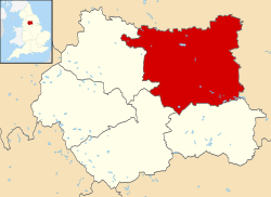 Leeds shown within West Yorkshire and England | |
| Coordinates: 53°47′59″N 1°32′57″W | |
| Sovereign state | United Kingdom |
| Constituent country | England |
| Region | Yorkshire and the Humber |
| Ceremonial county | West Yorkshire |
| Admin HQ | Leeds |
| Borough Charter | 1207 |
| Town Charter | 1626 |
| City status | 1893 |
| City of Leeds Met. District created | 1974 |
| Government | |
| • Type | Metropolitan borough, City |
| • Governing body | Leeds City Council |
| • Lord Mayor | Cllr Eileen Taylor (Labour) |
| • Leader of the Council | Cllr Judith Blake (Labour) |
| • Chief Executive | Tom Riordan |
| • MPs: | Stuart Andrew (C) Hilary Benn (L) Richard Burgon (L) Fabian Hamilton (L) Andrea Jenkyns (C) Rachel Reeves (L) Alec Shelbrooke (C) Alex Sobel (L) |
| Area | |
| • Total | 213 sq mi (551.72 km2) |
| Highest elevation | 1,120 ft (340 m) |
| Lowest elevation | 30 ft (10 m) |
| Population (mid-2018 est.) | |
| • Total | 789,194 (Ranked 2nd) |
| • Density | 3,574/sq mi (1,380/km2) |
| • Ethnicity (2011 census)[3] | 85% White 5.7% Asian or Asian British 3.5% Black or Black British 2.7% Mixed Race 3.1% Other |
| Time zone | UTC+0 (Greenwich Mean Time) |
| • Summer (DST) | UTC+1 (British Summer Time) |
| Postcode areas | LS, WF, BD |
| Area code(s) | 0113, 01924, 01937, 01943, 01977 |
| ISO 3166-2 | GB-LDS |
| ONS code | 00DA (ONS) E08000035 (GSS) |
| NUTS 3 | UKE42 |
| OS grid reference | SE296338 |
| Primary Airport | Leeds Bradford Airport |
| Website | www.leeds.gov.uk |
The current city boundaries were set on 1 April 1974 by the provisions of the Local Government Act 1972, as part a reform of local government in England. The city is a merger of eleven former local government districts; the unitary City and County Borough of Leeds combined with the municipal boroughs of Morley and Pudsey, the urban districts of Aireborough, Garforth, Horsforth, Otley and Rothwell, and parts of the rural districts of Tadcaster, Wharfedale and Wetherby from the West Riding of Yorkshire.
For its first 12 years the city had a two-tier system of local government; Leeds City Council shared power with the West Yorkshire County Council. Since the Local Government Act 1985 Leeds City Council has effectively been a unitary authority, serving as the sole executive, deliberative and legislative body responsible for local policy, setting council tax, and allocating budget in the city, and is a member of the Leeds City Region Partnership. The City of Leeds is divided into 31 civil parishes and a single unparished area.
History
Background
The Borough of Leeds was created in 1207, when Maurice Paynel, lord of the manor, granted a charter covering a small area adjacent to a crossing of the River Aire, between the old settlement centred on Leeds Parish Church to the east and the manor house and mills to the west. In 1626 a charter was granted by Charles I, incorporating the entire parish as the Borough of Leeds; it was reformed by the Municipal Corporations Act 1835. The parish and borough included the chapelries of Chapel Allerton, Armley, Beeston, Bramley, Farnley, Headingley cum Burley, Holbeck, Hunslet, Leeds, Potternewton and Wortley. The borough was located in the West Riding of Yorkshire and gained city status in 1893. When a county council was formed for the riding in 1889, Leeds was excluded from its area of responsibility and formed a county borough. The borough made a significant number of territorial expansions, expanding from 21,593 acres (87.38 km2) in 1911 to 40,612 acres (164.35 km2) in 1961;[6] adding in stages the former area of the Roundhay, Seacroft, Shadwell and Middleton parishes and gaining other parts of adjacent districts.
Formation
A review of local government arrangements completed in 1969 proposed the creation of a new large district centred on Leeds, occupying 317,000 acres (1,280 km2) and including 840,000 people. The proposed area was significantly reduced in a 1971 white paper; and within a year every local authority to be incorporated into it protested or demonstrated.[7] The final proposal reduced the area further and following the enactment of the Local Government Act 1972, the county borough was abolished on 1 April 1974 and its former area was combined with that of the municipal boroughs of Morley and Pudsey; the urban districts of Aireborough, Horsforth, Otley, Garforth and Rothwell; and parts of the rural districts of Tadcaster, Wetherby and Wharfedale. The new district gained both borough and city status, as had been held by the county borough; and forms part of the county of West Yorkshire.
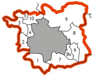
| Formation of the metropolitan district in 1974 | |
|---|---|
The former county borough is shaded in grey. Other areas:
|
 |
Geography
The district and its settlements are situated in the eastern foothills of the Pennines astride the River Aire whose valley, the Aire Gap, provides a road and rail corridor that facilitates communications with cities to the west of the Pennines. The district extends 15 miles (24 km) from east to west and 13 miles (21 km) from north to south; with over 65% covered with green belt land. The highest point, at 1,115 feet (340 m), is at its north western extremity on the eastern slopes of Rombalds Moor, better known as Ilkley Moor, on the boundary with the City of Bradford. The lowest points are at around 33 feet (10 m), in the east: where River Wharfe crosses the boundary with North Yorkshire south of Thorp Arch Trading Estate and where the River Aire (at this point forming the City of Wakefield boundary) meets the North Yorkshire boundary near Fairburn Ings. To the north and east Leeds is bordered by North Yorkshire: Harrogate district to the north and Selby district to the east. The remaining borders are with other districts of West Yorkshire: Wakefield to the south, Kirklees to the south west, and Bradford to the west.[8]
Governance
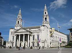
Leeds City Council is the local authority of the district. The council is composed of 99 councillors, three for each of the city's wards. Elections are held three years out of four, on the first Thursday of May. One third of the councillors are elected, for a four-year term, in each election. 2004 saw all seats up for election due to boundary changes. It is currently run by a Labour administration. Before the 2011 election, the council had been under no overall control since 2004. The Chief Executive of Leeds City Council is Tom Riordan while the Leader of the Council is Councillor Judith Blake of the Labour Party. As a metropolitan county, West Yorkshire does not have a county council, so Leeds City Council is the primary provider of local government services. The district forms part of the Yorkshire and the Humber region of England.
Most of the district is an unparished area, comprising Leeds itself (the area of the former county borough), Pudsey, Garforth, Rothwell and the area of the former urban district of Aireborough. In the unparished area there is no lower tier of government. Outside the unparished area there are 38 civil parishes, represented by parish councils. These form the lowest tier of local government[9] and absorb some limited functions from Leeds City Council in their areas. The councils of the civil parishes of Horsforth, Morley, Otley and Wetherby are town councils.[10] The 34 other civil parishes are:[11]
|
|
|
|
The district is represented by eight MPs, for the constituencies of Elmet and Rothwell (Alec Shelbrooke, Conservative); Leeds Central (Hilary Benn, Labour); Leeds East (Richard Burgon, Labour); Leeds North East (Fabian Hamilton, Labour); Leeds North West (Alex Sobel, Labour); Leeds West (Rachel Reeves, Labour); Morley and Outwood (constituency shared with City of Wakefield) (Andrea Jenkyns, Conservative); and Pudsey (Stuart Andrew, Conservative).
Demography
| Leeds compared | |||
|---|---|---|---|
| 2001 UK Census[12] | City of Leeds metropolitan district | Yorkshire and the Humber | England |
| Population | 715,402 | 4,964,833 | 49,138,831 |
| White | 91.8% | 93.5% | 90.9% |
| Asian | 4.5% | 4.5% | 4.6% |
| Black | 1.4% | 0.7% | 2.3% |
At the 2001 UK census, the district had a total population of 715,402.[12] Of the 301,614 households in Leeds, 33.3% were married couples living together, 31.6% were one-person households, 9.0% were co-habiting couples and 9.8% were lone parents, following a similar trend to the rest of England.[13] The population density was 1,967/km2 (5,090/sq mi)[13] and for every 100 females, there were 93.5 males. Of those aged 16–74, 30.9% had no academic qualifications, higher than the 28.9% in all of England.[14] Of the residents, 6.6% were born outside the United Kingdom, lower than the England average of 9.2%.[15]
The majority of people in Leeds identify themselves as Christian.[16] The proportion of Muslims is average for the country.[16] Leeds has the third-largest Jewish community in the United Kingdom, after those of London and Manchester. The areas of Alwoodley and Moortown contain sizeable Jewish populations.[17] 16.8% of Leeds residents in the 2001 census declared themselves as having "no religion", which is broadly in line with the figure for the whole of the UK (also 8.1% "religion not stated").
The crime rate in Leeds is well above the national average, like many other English major cities.[18][19] In July 2006, the think tank Reform calculated rates of crime for different offences and has related this to populations of major urban areas (defined as towns over 100,000 population). Leeds was 11th in this rating (excluding London boroughs, 23rd including London boroughs).[20] The table below details the population of the current area of the district since 1801, including the percentage change since the last available census data.
| Population growth in City of Leeds since 1801 | |||||||||||||||||||||
|---|---|---|---|---|---|---|---|---|---|---|---|---|---|---|---|---|---|---|---|---|---|
| Year | 1801 | 1811 | 1821 | 1831 | 1841 | 1851 | 1861 | 1871 | 1881 | 1891 | 1901 | 1911 | 1921 | 1931 | 1941 | 1951 | 1961 | 1971 | 1981 | 1991 | 2001 |
| Population | 94,421 | 108,459 | 137,476 | 183,015 | 222,189 | 249,992 | 311,197 | 372,402 | 433,607 | 503,493 | 552,479 | 606,250 | 625,854 | 646,119 | 668,667 | 692,003 | 715,260 | 739,401 | 696,732 | 716,760 | 715,404 |
| % change | – | +14.87 | +26.75 | +33.13 | +21.40 | +12.51 | +24.48 | +19.67 | +16.44 | +16.12 | +9.73 | +9.73 | +3.23 | +3.24 | +3.49 | +3.49 | +3.36 | +3.38 | −5.77 | +2.87 | −0.19 |
| Source: Vision of Britain[21] | |||||||||||||||||||||
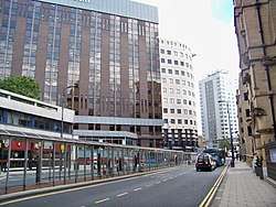
Economy
Leeds has a diverse economy with the service sector now dominating over the traditional manufacturing industries. It is the location of one of the largest financial centres in England outside London. New tertiary industries such as retail, call centres, offices and media have contributed to a high rate of economic growth. This is a chart of trend of regional gross value added of Leeds at current basic prices with figures in millions of British pounds sterling.[22]
| Year | Regional Gross Value Added4 | Agriculture1 | Industry2 | Services3 |
|---|---|---|---|---|
| 1995 | 8,713 | 43 | 2,652 | 6,018 |
| 2000 | 11,681 | 32 | 2,771 | 8,878 |
| 2003 | 13,637 | 36 | 3,018 | 10,583 |
Education
Education Leeds, a non-profit company owned by Leeds City Council, provided educational services between 2001 and 2011. In April 2011 Leeds City Council disbanded Education Leeds and has consolidated educational services into the Children's Services Department of the council itself.[23]
Transport
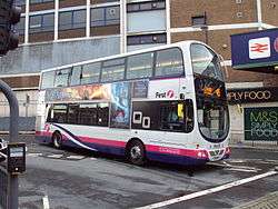
Leeds city centre is connected to the National Rail network at Leeds railway station. Public transport in West Yorkshire is coordinated by the West Yorkshire Passenger Transport Executive, under the control of a joint-board of local authorities in the county and including Leeds City Council.
Twin cities
The City has several twinning or partnership arrangements:
Notes and references
Notes
- ^1 includes hunting and forestry
- ^2 includes energy and construction
- ^3 includes financial intermediation services indirectly measured
- ^4 Components may not sum to totals due to rounding
References
- Max at SE140445 Hawksworth Moor in extreme west of city
- Min at points where city boundary crosses Rivers Aire and Wharfe in extreme east.
- National Statistics: Neighbourhood Statistics. "Ethnicity and National Identity in England and Wales 2011". Archived from the original on 10 January 2013. Retrieved 29 April 2015.
- "Leeds". Collins Dictionary. n.d. Archived from the original on 3 March 2016. Retrieved 24 September 2014.
- Van den Berg 2006, p. 179.
- Great Britain Historical GIS / University of Portsmouth, Leeds MB/CB (historic map) population (area ). Retrieved 24 September 2009.
- Derek Fraser (1982). A History of modern Leeds. Manchester University Press.
- "Leeds Maps - Leeds City Region". Leeds City Council. Archived from the original on 19 June 2009. Retrieved 16 April 2009.
- "Parish and Town Councils". Leeds City Council. Archived from the original on 5 April 2009. Retrieved 1 April 2009.
- "Leeds civil parish map 2008". Leeds City Council. Archived from the original on 27 September 2011. Retrieved 1 April 2009.
- "Children of Leeds City Council". Mapit. Retrieved 21 November 2019.
- "Leeds Metropolitan Borough ethnic group". Office for National Statistics. Archived from the original on 4 June 2011. Retrieved 22 July 2009.
- "Leeds Metropolitan Borough household composition (households)". Office for National Statistics. Archived from the original on 4 June 2011. Retrieved 22 July 2009.
- "Leeds Metropolitan Borough key statistics". Office for National Statistics. Archived from the original on 4 June 2011. Retrieved 22 July 2009.
- "Leeds Metropolitan Borough country of birth data". Office for National Statistics. Archived from the original on 4 June 2011. Retrieved 22 July 2009.
- "Leeds Census 2001". Archived from the original on 5 June 2011. Retrieved 24 September 2009.
- M. Freedman (1988) "The Leeds Jewish Community" pp. 161–174 in L. S. Tate (ed) Aspects of Leeds ISBN 1-871647-38-X
- "Crime figures in Leeds". Archived from the original on 9 October 2008.
- "Crime Statistics for Leeds Apr 2005 - Mar 2006". Home Office. Archived from the original on 6 June 2008. Retrieved 23 September 2009.
- "Urban Crime Rankings" (PDF). July 2006. pp. 43, 45. Archived from the original (PDF) on 11 October 2006.
- "Leeds District: total population". Vision of Britain. Archived from the original on 11 January 2012. Retrieved 19 December 2008.
- "Regional Gross Value Added" (PDF). Office for National Statistics. pp. 240–253. Archived from the original (PDF) on 25 May 2006.
- "Education Leeds – the organisation". EducationLeeds.co.uk. Archived from the original on 20 April 2013. Retrieved 22 July 2009.
- "Leeds – Brno partnership". Leeds.gov.uk. Archived from the original on 1 January 2009. Retrieved 14 October 2008.
- "City of Brno Foreign Relations - Statutory city of Brno". www2.brno.cz (in Czech). Archived from the original on 15 January 2016. Retrieved 6 September 2011.
- "Brno – Partnerská města". www.brno.cz (in Czech). 2006–2009. Archived from the original on 25 August 2009. Retrieved 17 July 2009.
- "Leeds – Dortmund partnership". Leeds.gov.uk. Archived from the original on 4 December 2008. Retrieved 14 October 2008.
- "List of Twin Towns in the Ruhr District" (PDF). www.twins2010.com. Archived from the original (PDF) on 28 November 2009. Retrieved 28 October 2009.
- "Leeds – Durban partnership". Leeds.gov.uk. Archived from the original on 10 August 2009. Retrieved 14 October 2008.
- "Leeds – Hangzhou partnership". Leeds.gov.uk. Archived from the original on 11 December 2007. Retrieved 14 October 2008.
- "British towns twinned with French towns". Archant Community Media Ltd. Archived from the original on 5 July 2013. Retrieved 11 July 2013.
- "Leeds – Lille partnership". Leeds.gov.uk. Archived from the original on 11 December 2007. Retrieved 14 October 2008.
- "Leeds – Louisville partnership". Leeds.gov.uk. Archived from the original on 11 December 2007. Retrieved 14 October 2008.
- "Leeds – Siegen partnership". Leeds.gov.uk. Archived from the original on 27 September 2011. Retrieved 14 October 2008.
Bibliography
- Burt, Steven; Grady, Kevin (1994), The Illustrated History of Leeds, Breedon Books, ISBN 1-873626-35-5
- Fraser, Derek (1982), A History of Modern Leeds, Manchester University Press, ISBN 978-0-7190-0781-1
- Van den Berg, Leo (2006), The Safe City: Safety and Urban Development in European Cities, Ashgate, ISBN 978-0-7546-4723-2
External links
![]()

- Leeds City Council Leeds City Council.
- 'Leeds Chamber of Commerce & Industry' Leeds Chamber of Commerce & Industry.
- 'Leeds Initiative' Leeds Initiative city partnership.
- Leodis Leeds Library & Information Service photograph archive.
| Topics |
| ||||||||||||
|---|---|---|---|---|---|---|---|---|---|---|---|---|---|
| Events |
| ||||||||||||
| Culture |
| ||||||||||||
| Politics |
| ||||||||||||
| Transport |
| ||||||||||||
| Sport |
| ||||||||||||
| Parks, gardens & squares |
| ||||||||||||
| Areas |
| ||||||||||||
| |||||||||||||
Districts of Yorkshire and the Humber | ||
|---|---|---|
| Lincolnshire |  | |
| North Yorkshire | ||
| South Yorkshire |
| |
| West Yorkshire |
| |
| East Riding of Yorkshire | ||
| Districts |
|  |
|---|---|---|
| Councils |
| |
| Local elections |
| |