Cape Town
Cape Town (Khoekhoegowab: ǁHui!gaeb; Afrikaans: Kaapstad [ˈkɑːpstat]; Xhosa: iKapa;) is the second most populous city in South Africa after Johannesburg and also the legislative capital of South Africa. Colloquially named the Mother City, it is the largest city of the Western Cape province[7] and forms part of the City of Cape Town metropolitan municipality. The Parliament of South Africa sits in Cape Town.[8] The other two capitals are located in Pretoria (the executive capital where the Presidency is based) and Bloemfontein (the judicial capital where the Supreme Court of Appeal is located).[9] The city is known for its harbour, for its natural setting in the Cape Floristic Region, and for landmarks such as Table Mountain and Cape Point. Cape Town is home to 64% of the Western Cape's population.[10] The city was named the World Design Capital for 2014 by the International Council of Societies of Industrial Design.[11]
Cape Town ǁHui!gaeb (in Khoekhoegowab) Kaapstad (in Afrikaans) iKapa (in Xhosa) | |
|---|---|
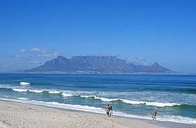  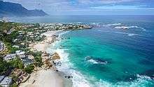 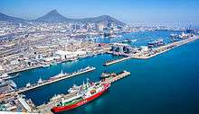  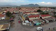 From top, left to right: Cape Town at the foot of Table Mountain as seen from Bloubergstrand, Cape Town's City Bowl Skyline, Clifton beach, Strand, Port of Cape Town, Manenberg. | |
Flag | |
| Nicknames: Mother City, Tavern of the Seas, West side | |
| Motto(s): Spes Bona (Latin for "Good Hope") | |
 Cape Town 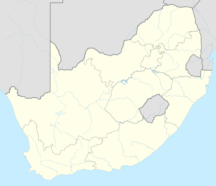 Cape Town  Cape Town | |
| Coordinates: 33°55′31″S 18°25′26″E | |
| Country | |
| Province | Western Cape |
| Municipality | City of Cape Town |
| Founded | 1652 |
| Municipal government | 1839 |
| Government | |
| • Type | Metropolitan municipality |
| • Mayor | Dan Plato (DA) |
| • Deputy Mayor | Ian Neilson (DA) |
| Area | |
| • City | 400.28 km2 (154.55 sq mi) |
| • Metro | 2,461 km2 (950 sq mi) |
| Highest elevation | 1,590.4 m (5,217.8 ft) |
| Lowest elevation | 0 m (0 ft) |
| Population (2018)[2] | |
| • City | 3,776,000 |
| • Density | 9,400/km2 (24,000/sq mi) |
| • Metro | 4,005,015 |
| • Metro density | 1,600/km2 (4,200/sq mi) |
| Demonym(s) | Capetonian |
| Racial makeup (2011) | |
| • Black African | 15.8% |
| • Coloured | 44.6% |
| • Indian/Asian | 3.4% |
| • White | 32.3% |
| • Other | 3.9% |
| First languages (2011) | |
| • English | 67.7% |
| • Afrikaans | 22.5% |
| • Xhosa | 2.7% |
| • Other | 7.1% |
| Time zone | UTC+2 (SAST) |
| Postal codes (street) | 7400–8099 |
| PO box | 8000 |
| GDP | US$78.7 billion[6] |
| GDP per capita | US$19,656[6] |
| Website | www |
In 2014, Cape Town was named the best place in the world to visit by both The New York Times[12] and The Daily Telegraph.[13] Cape Town was one of the host cities of the tournaments of 1995 Rugby World Cup and 2010 FIFA World Cup.
Located on the shore of Table Bay, Cape Town, as the oldest urban area in South Africa, was developed by the United East India Company (VOC) as a supply station for Dutch ships sailing to East Africa, India, and the Far East. Jan van Riebeeck's arrival on 6 April 1652 established VOC Cape Colony, the first permanent European settlement in South Africa. Cape Town outgrew its original purpose as the first European outpost at the Castle of Good Hope, becoming the economic and cultural hub of the Cape Colony. Until the Witwatersrand Gold Rush and the development of Johannesburg, Cape Town was the largest city in South Africa.
History
.jpg)

Early history
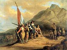
The earliest known remnants in the region were found at Peers Cave in Fish Hoek and date to between 15,000 and 12,000 years ago.[14] Little is known of the history of the region's first residents, since there is no written history from the area before it was first mentioned by Portuguese explorer Bartolomeu Dias in 1488 who was the first European to reach the area and named it "Cape of Storms" (Cabo das Tormentas). It was later renamed by John II of Portugal as "Cape of Good Hope" (Cabo da Boa Esperança) because of the great optimism engendered by the opening of a sea route to India and the East. Vasco da Gama recorded a sighting of the Cape of Good Hope in 1497. In 1510, at the Battle of Salt River, Francisco de Almeida and fifty of his men were killed and his party were defeated[15] by ox-mounted !Uriǁ’aekua ("Goringhaiqua" in Dutch approximate spelling), which was one of the so-called Khoekhoe clans of the area that also included the !Uriǁ’aeǀ’ona ("Goringhaicona" in Dutch approximate spelling, also known as "Strandlopers"), said to be the ancestors of the !Ora nation of today. In the late 16th century, Portuguese, French, Danish, Dutch and English but mainly Portuguese ships regularly continued to stop over in Table Bay en route to the Indies. They traded tobacco, copper and iron with the Khoekhoe-speaking clans of the region, in exchange for fresh meat.
Dutch period
In 1652, Jan van Riebeeck and other employees of the United East India Company (Dutch: Verenigde Oost-indische Compagnie, VOC) were sent to the Cape to establish a way-station for ships travelling to the Dutch East Indies, and the Fort de Goede Hoop (later replaced by the Castle of Good Hope). The settlement grew slowly during this period, as it was hard to find adequate labour. This labour shortage prompted the authorities to import slaves from Indonesia and Madagascar. Many of these became ancestors of the first Cape Coloured communities.[16][17] Under Van Riebeeck and his successors as VOC commanders and later governors at the Cape, an impressive range of useful plants were introduced to the Cape – in the process changing the natural environment forever. Some of these, including grapes, cereals, ground nuts, potatoes, apples and citrus, had an important and lasting influence on the societies and economies of the region.[18]
British period
The Dutch Republic being transformed in Revolutionary France's vassal Batavian Republic, Great Britain moved to take control of its colonies. Britain captured Cape Town in 1795, but the Cape was returned to the Dutch by treaty in 1803. British forces occupied the Cape again in 1806 following the Battle of Blaauwberg. In the Anglo-Dutch Treaty of 1814, Cape Town was permanently ceded to the United Kingdom. It became the capital of the newly formed Cape Colony, whose territory expanded very substantially through the 1800s. With expansion came calls for greater independence from the UK, with the Cape attaining its own parliament (1854) and a locally accountable Prime Minister (1872). Suffrage was established according to the non-racial, but sexist Cape Qualified Franchise.[19][20]
During the 1850s and 1860s additional plant species were introduced from Australia by the British authorities. Notably rooikrans to stabilise the sand of the Cape Flats to allow for a road connecting the peninsula with the rest of the African continent[21] and eucalyptus to drain marshes so as to help to eliminate malaria.[22] The discovery of diamonds in Griqualand West in 1867, and the Witwatersrand Gold Rush in 1886, prompted a flood of immigrants to South Africa.[23] Conflicts between the Boer republics in the interior and the British colonial government resulted in the Second Boer War of 1899–1902, which Britain won.
South African period
In 1910, Britain established the Union of South Africa, which unified the Cape Colony with the two defeated Boer Republics and the British colony of Natal. Cape Town became the legislative capital of the Union, and later of the Republic of South Africa.
_at_Cape_Town_in_October_1948.jpg)
Prior to the mid-twentieth century the Cape Town was arguably the most racially integrated city in the South Africa.[25][26] In the 1948 national elections, the National Party won on a platform of apartheid (racial segregation) under the slogan of "swart gevaar". This led to the erosion and eventual abolition of the Cape's multiracial franchise, as well as to the Group Areas Act, which classified all areas according to race. Formerly multi-racial suburbs of Cape Town were either purged of residents deemed unlawful by apartheid legislation or demolished. The most infamous example of this in Cape Town was District Six. After it was declared a whites-only region in 1965, all housing there was demolished and over 60,000 residents were forcibly removed.[27] Many of these residents were relocated to the Cape Flats and Lavender Hill. Under apartheid, the Cape was considered a "Coloured labour preference area", to the exclusion of "Bantus", i.e. Africans. The implementation of this policy was widely opposed by trade unions, civil society and opposition parties. It is notable that this policy was not advocated for by any coloured person, and its implementation was a unilateral decision by the apartheid government.[28]
School students from Langa, Gugulethu and Nyanga in Cape Town reacted to the news of protests against Bantu Education in Soweto in June 1976 and organised gatherings and marches, which were met with resistance from the police. A number of school buildings were burnt down.[29][30]
Cape Town was home to many leaders of the anti-apartheid movement. On Robben Island, a former penitentiary island 10 kilometres (6 miles) from the city, many famous political prisoners were held for years. In one of the most famous moments marking the end of apartheid, Nelson Mandela made his first public speech since his imprisonment, from the balcony of Cape Town City Hall hours after being released on 11 February 1990. His speech heralded the beginning of a new era for the country, and the first democratic election, was held four years later, on 27 April 1994. Nobel Square in the Victoria & Alfred Waterfront features statues of South Africa's four Nobel Peace Prize winners: Albert Luthuli, Desmond Tutu, F. W. de Klerk and Nelson Mandela.
Geography

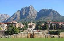
Cape Town is located at latitude 33.55° S (approx. the same as Sydney and Buenos Aires and equivalent to Casablanca and Los Angeles in the northern hemisphere) and longitude 18.25° E. Table Mountain, with its near vertical cliffs and flat-topped summit over 1,000 m (3,300 ft) high, and with Devil's Peak and Lion's Head on either side, together form a dramatic mountainous backdrop enclosing the central area of Cape Town, the so-called City Bowl. A thin strip of cloud, known colloquially as the "tablecloth", sometimes forms on top of the mountain. To the immediate south, the Cape Peninsula is a scenic mountainous spine jutting 40 kilometres (25 mi) southwards into the Atlantic Ocean and terminating at Cape Point. There are over 70 peaks above 300 m (980 ft) within Cape Town's official city limits. Many of the city's suburbs lie on the large plain called the Cape Flats, which extends over 50 kilometres (30 mi) to the east and joins the peninsula to the mainland. The Cape Town region is characterised by an extensive coastline, rugged mountain ranges, coastal plains, inland valleys and semi-desert fringes.
Robben Island
UNESCO declared Robben Island in the Western Cape a World Heritage Site in 1999. Robben Island is located in Table Bay, some 6 km (3.7 mi) west of Bloubergstrand in Cape Town, and stands some 30m above sea level. Robben Island has been used as a prison where people were isolated, banished and exiled to for nearly 400 years. It was also used as a leper colony, a post office, a grazing ground, a mental hospital, and an outpost.[31]
Currently visitors can only access the island via the Robben Island Museum boat service, which runs three times daily until the beginning of the peak season (1 September). The ferries depart from the Nelson Mandela Gateway at the V&A Waterfront.
Climate
Cape Town has a warm Mediterranean climate (Köppen "Csb"),[32][33][34] with mild, moderately wet winters and dry, warm summers. Winter, which lasts from the beginning of June to the end of August, may see large cold fronts entering for limited periods from the Atlantic Ocean with significant precipitation and strong north-westerly winds. Winter months in the city average a maximum of 18 °C (64 °F) and minimum of 8.5 °C (47 °F)[35] Total annual rainfall in the city averages 515 millimetres (20.3 in) although in the southern suburbs, close to the mountains, rainfall is significantly higher and averages closer to 1000 millimetres (40 in). Summer, which lasts from December to March, is warm and dry with an average maximum of 26 °C (79 °F) and minimum of 16 °C (61 °F). The region can get uncomfortably hot when the Berg Wind, meaning "mountain wind", blows from the Karoo interior for a couple of weeks in February or March. Spring and summer generally feature a strong wind from the south-east, known locally as the south-easter or the Cape Doctor, so called because it blows air pollution away. This wind is caused by a high-pressure system which sits in the South Atlantic to the west of Cape Town, known as the South Atlantic High. Cape Town receives 3,100 hours of sunshine per year.[36]
Water temperatures range greatly, between 10 °C (50 °F) on the Atlantic Seaboard, to over 22 °C (72 °F) in False Bay. Average annual Ocean temperatures are between 13 °C (55 °F) on the Atlantic Seaboard (similar to Californian waters, such as San Francisco or Big Sur), and 17 °C (63 °F) in False Bay (similar to Northern Mediterranean temperatures, such as Nice or Monte Carlo).
| Climate data for Cape Town (1961–1990) | |||||||||||||
|---|---|---|---|---|---|---|---|---|---|---|---|---|---|
| Month | Jan | Feb | Mar | Apr | May | Jun | Jul | Aug | Sep | Oct | Nov | Dec | Year |
| Record high °C (°F) | 39.3 (102.7) |
38.3 (100.9) |
43.0 (109.4) |
38.6 (101.5) |
33.5 (92.3) |
29.8 (85.6) |
29.0 (84.2) |
32.0 (89.6) |
33.1 (91.6) |
37.2 (99.0) |
39.9 (103.8) |
41.4 (106.5) |
43.0 (109.4) |
| Mean maximum °C (°F) | 33.6 (92.5) |
34.1 (93.4) |
33.2 (91.8) |
31.7 (89.1) |
29.1 (84.4) |
26.3 (79.3) |
25.1 (77.2) |
26.9 (80.4) |
28.3 (82.9) |
31.0 (87.8) |
31.6 (88.9) |
32.5 (90.5) |
34.1 (93.4) |
| Average high °C (°F) | 26.1 (79.0) |
26.5 (79.7) |
25.4 (77.7) |
23.0 (73.4) |
20.3 (68.5) |
18.1 (64.6) |
17.5 (63.5) |
17.8 (64.0) |
19.2 (66.6) |
21.3 (70.3) |
23.5 (74.3) |
24.9 (76.8) |
22.0 (71.5) |
| Daily mean °C (°F) | 20.4 (68.7) |
20.4 (68.7) |
19.2 (66.6) |
16.9 (62.4) |
14.4 (57.9) |
12.5 (54.5) |
11.9 (53.4) |
12.4 (54.3) |
13.7 (56.7) |
15.6 (60.1) |
17.9 (64.2) |
19.5 (67.1) |
16.2 (61.2) |
| Average low °C (°F) | 15.7 (60.3) |
15.6 (60.1) |
14.2 (57.6) |
11.9 (53.4) |
9.4 (48.9) |
7.8 (46.0) |
7.0 (44.6) |
7.5 (45.5) |
8.7 (47.7) |
10.6 (51.1) |
13.2 (55.8) |
14.9 (58.8) |
11.4 (52.5) |
| Mean minimum °C (°F) | 10.3 (50.5) |
9.9 (49.8) |
7.6 (45.7) |
5.7 (42.3) |
2.8 (37.0) |
1.3 (34.3) |
1.0 (33.8) |
1.3 (34.3) |
2.3 (36.1) |
4.4 (39.9) |
7.0 (44.6) |
9.5 (49.1) |
1.0 (33.8) |
| Record low °C (°F) | 7.4 (45.3) |
6.4 (43.5) |
4.6 (40.3) |
2.4 (36.3) |
0.9 (33.6) |
−1.2 (29.8) |
−4.3 (24.3) |
−0.4 (31.3) |
0.2 (32.4) |
1.0 (33.8) |
3.9 (39.0) |
6.2 (43.2) |
−4.3 (24.3) |
| Average precipitation mm (inches) | 15 (0.6) |
17 (0.7) |
20 (0.8) |
41 (1.6) |
69 (2.7) |
93 (3.7) |
82 (3.2) |
77 (3.0) |
40 (1.6) |
30 (1.2) |
14 (0.6) |
17 (0.7) |
515 (20.4) |
| Average precipitation days (≥ 0.1 mm) | 5.5 | 4.6 | 4.8 | 8.3 | 11.4 | 13.3 | 11.8 | 13.7 | 10.4 | 8.7 | 4.9 | 6.3 | 103.7 |
| Average relative humidity (%) | 71 | 72 | 74 | 78 | 81 | 81 | 81 | 80 | 77 | 74 | 71 | 71 | 76 |
| Mean monthly sunshine hours | 337.9 | 297.4 | 292.9 | 233.5 | 205.3 | 175.4 | 193.1 | 212.1 | 224.7 | 277.7 | 309.8 | 334.2 | 3,094 |
| Source: World Meteorological Organization,[35] NOAA,[36] South African Weather Service,[37] eNCA[38] | |||||||||||||
Flora and fauna
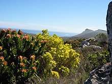
Located in a CI Biodiversity hotspot as well as the unique Cape Floristic Region, the city of Cape Town has one of the highest levels of biodiversity of any equivalent area in the world.[39] These protected areas are a World Heritage Site, and an estimated 2,200 species of plants are confined to Table Mountain – more than exist in the whole of the United Kingdom which has 1200 plant species and 67 endemic plant species.[40][41][42] Many of these species, including a great many types of proteas, are endemic to the mountain and can be found nowhere else.[43]
It is home to a total of 19 different vegetation types, of which several are endemic to the city and occur nowhere else in the world.[44] It is also the only habitat of hundreds of endemic species,[45] and hundreds of others which are severely restricted or threatened. This enormous species diversity is mainly because the city is uniquely located at the convergence point of several different soil types and micro-climates.
Table Mountain has an unusually rich biodiversity. Its vegetation consists predominantly of several different types of the unique and rich Cape Fynbos. The main vegetation type is endangered Peninsula Sandstone Fynbos, but critically endangered Peninsula Granite Fynbos, Peninsula Shale Renosterveld and Afromontane forest occur in smaller portions on the mountain.
Unfortunately, rapid population growth and urban sprawl has covered much of these ecosystems with development. Consequently, Cape Town now has over 300 threatened plant species and 13 which are now extinct. The Cape Peninsula, which lies entirely within the city of Cape Town, has the highest concentration of threatened species of any continental area of equivalent size in the world.[46] Tiny remnant populations of critically endangered or near extinct plants sometimes survive on road sides, pavements and sports fields.[47] The remaining ecosystems are partially protected through a system of over 30 nature reserves – including the massive Table Mountain National Park.
Cape Town reached first place in the 2019 iNaturalist City Nature Challenge in two out of the three categories: Most Observations, and Most Species. This was the first entry by Capetonians in this annual competition to observe and record the local biodiversity over a four-day long weekend during what is considered the worst time of the year for local observations.[48] However, a worldwide survey showed that the extinction rate of endemic plants from the City of Cape Town is one of the highest in the world, at roughly three per year since 1900 - partly a consequence of the very small and localised habitats and high endemicity.[49]
Suburbs

Cape Town's urban geography is influenced by the contours of Table Mountain,[50] its surrounding peaks, the Durbanville Hills, and the expansive lowland region known as the Cape Flats. These geographic features in part divide the city into several commonly known groupings of suburbs (equivalent to districts outside South Africa), many of which developed historically together and share common attributes of language and culture.
City Bowl

The City Bowl is a natural amphitheatre-shaped area bordered by Table Bay and defined by the mountains of Signal Hill, Lion's Head, Table Mountain and Devil's Peak.
The area includes the central business district of Cape Town, the harbour, the Company's Garden, and the residential suburbs of De Waterkant, Devil's Peak, District Six, Zonnebloem, Gardens, Bo-Kaap, Higgovale, Oranjezicht, Schotsche Kloof, Tamboerskloof, University Estate, Vredehoek, Walmer Estate and Woodstock.
The Foreshore Freeway Bridge has stood in its unfinished state since construction officially ended in 1977. It was intended to be the Eastern Boulevard Highway in the city bowl, but is unfinished due to budget constraints.
Atlantic Seaboard

The Atlantic Seaboard lies west of the City Bowl and Table Mountain, and is characterised by its beaches, cliffs, promenade and hillside communities. The area includes, from north to south, the neighbourhoods of Green Point, Mouille Point, Three Anchor Bay, Sea Point, Fresnaye, Bantry Bay, Clifton, Camps Bay, Llandudno, and Hout Bay. The Atlantic Seaboard has some of the most expensive real estate in South Africa particularly on Nettleton and Clifton Roads in Clifton, Ocean View Drive and St Leon Avenue in Bantry Bay, Theresa Avenue in Bakoven and Fishermans Bend in Llandudno. Camps Bay is home to the highest concentration of multimillionaires in Cape Town and has the highest number of high-priced mansions in South Africa with more than 155 residential units exceeding R20 million (or $US1.8 million).[51]
West Coast
The West Coast suburbs lie along the beach to the north of the Cape Town city centre, and include Bloubergstrand, Milnerton, Tableview, West Beach, Big Bay, Sunset Beach, Sunningdale, Parklands and Parklands North, as well as the exurbs of Atlantis and Melkbosstrand. The Koeberg Nuclear Power Station is located within this area and maximum housing density regulations are enforced in much of the area surrounding the nuclear plant.
Northern Suburbs
.jpg)
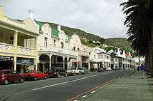
The Northern Suburbs are Afrikaans-speaking, and include Bellville, Kanonberg, Bothasig, Brooklyn, Burgundy Estate, Durbanville, Edgemead, Brackenfell, Elsie's River, Factreton, Kraaifontein, Goodwood, Kensington, Maitland, Monte Vista, Panorama, Parow, Richwood, Welgemoed, Fairdale, Kraaifontein, Kuils River, Blue Downs, Belhar, Delft, Mfuleni and Protea Heights.
The Northern Suburbs are home to Tygerberg Hospital, the largest hospital in the Western Cape and second largest in South Africa[52]
Southern Suburbs
The Southern Suburbs lie along the eastern slopes of Table Mountain, southeast of the city centre. This area has mixed languages but is predominantly English-speaking, and includes, from north to south, Observatory, Mowbray, Pinelands, Rosebank, Rondebosch, Rondebosch East, Newlands, Claremont, Lansdowne, Kenilworth, Bishopscourt, Constantia, Wynberg, Plumstead, Ottery, Bergvliet and Diep River. West of Wynberg lies Constantia which, in addition to being a wealthy neighbourhood, is a notable wine-growing region within the City of Cape Town, and attracts tourists for its well-known wine farms and Cape Dutch architecture.[53]
South Peninsula
The South Peninsula is generally regarded as the area South of Muizenberg on False Bay and Noordhoek on the Atlantic Ocean, all the way to Cape Point. Until recently, this predominantly English-speaking area was quite rural, however the population of the area is growing quickly as new coastal developments proliferate and larger plots are subdivided to provide more compact housing. It includes Capri Village, Clovelly, Fish Hoek, Glencairn, Kalk Bay, Kommetjie, Masiphumelele, Muizenberg, Noordhoek, Ocean View, Scarborough, Simon's Town, St James, Sunnydale and Sun Valley. South Africa's largest naval base is located at Simon's Town harbour, and close by is Boulders Beach, the site of a large colony of African penguins.[54]
Cape Flats
The Cape Flats is an expansive, low-lying, flat area situated to the southeast of the city centre.
Due to the region having a Mediterranean climate, the wettest months on the Cape Flats are from April to September, with 82% most of its rainfall occurring between these months. The rainfall patterns on the Cape Flats vary with longitude, such that the eastern parts get a minimum of 214mm per year and the central and western parts get 800mm per year. A significant portion of this water ends up in the Cape Flats Aquifer, which lie beneath the central and southern parts of the Cape Flats. Most of the land of the Cape Flats is used for residential areas, the majority of which are formal, but with several informal settlements present. Light industrial areas are also found in the area. A part of the land in the south-east is used for cultivation and contains many smallholdings.[55]
Helderberg
The Helderberg consists of Somerset West, Strand, Gordons Bay and a few other suburbs which were previously towns in the Helderberg district. The district takes its name from the imposing Helderberg Mountain, which reaches a height of 1,137 metres (3,730 feet)
Government
Cape Town is governed by a 231-member city council elected in a system of mixed-member proportional representation. The city is divided into 116 wards, each of which elects a councillor by first-past-the-post voting. The remaining 115 councillors are elected from party lists so that the total number of councillors for each party is proportional to the number of votes received by that party.[56][57]
In the local government elections of 3 August 2016, the Democratic Alliance (DA) won an outright majority, taking 154 of the 231 council seats. The African National Congress, the national ruling party, received 57 seats.[58] As a result of this victory, Patricia de Lille of the Democratic Alliance was re-elected to a second term as Executive Mayor. However, De Lille resigned as Mayor on 31 October 2018. The Democratic Alliance designated Dan Plato as their candidate to replace her.[59]
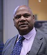 Mayor of Cape Town Dan Plato.
 The Old Cape Town City Hall as seen from the Grand Parade in front of the building.
 The Cape Town Civic Centre, the central offices of the City of Cape Town.
 South Africa's national parliament building is located in Cape Town.
Demographics
| Historical population | |||||||||||||||||||||||||||||||||||||||||||||||||||||||||||||||||||
|---|---|---|---|---|---|---|---|---|---|---|---|---|---|---|---|---|---|---|---|---|---|---|---|---|---|---|---|---|---|---|---|---|---|---|---|---|---|---|---|---|---|---|---|---|---|---|---|---|---|---|---|---|---|---|---|---|---|---|---|---|---|---|---|---|---|---|---|
|
| ||||||||||||||||||||||||||||||||||||||||||||||||||||||||||||||||||
| Note: Census figures (1996–2011) cover figures after 1994 reflect the greater Cape Town metropolitan municipality reflecting post-1994 reforms. Sources: 1658–1904,[60] 1950–1990,[61] 1996,[62] 2001, and 2011 Census;[63] 2007,[64] 2018 Census estimates.[65] | |||||||||||||||||||||||||||||||||||||||||||||||||||||||||||||||||||
According to the South African National Census of 2011, the population of the City of Cape Town metropolitan municipality – an area that includes suburbs and exurbs not always considered as part of Cape Town – is 3,740,026 people. This represents an annual growth rate of 2.6% compared to the results of the previous census in 2001 which found a population of 2,892,243 people.[66] :54 The sex ratio is 96, meaning that there are slightly more women than men.[66]:55 42.4% of the population described themselves as "Coloured", 15.7% as "White", 38.6% as "Black African", 1.4% as "Indian or Asian"[66]:56–59and 1.9% as "Other".
In 1944, 47% of the city's population was White, 46% was Coloured, less than 6% was Black African and 1% was Asian.[67]
Of those residents who were asked about their first language, 35.7% spoke Afrikaans, 29.8% spoke Xhosa and 28.4% spoke English. 24.8% of the population is under the age of 15, while 5.5% is 65 or older.[66]:64
Of those residents aged 20 or older, 1.8% have no schooling, 8.1% have some schooling but did not finish primary school, 4.6% finished primary school but have no secondary schooling, 38.9% have some secondary schooling but did not finish Grade 12, 29.9% finished Grade 12 but have no higher education, and 16.7% have higher education. Overall, 46.6% have at least a Grade 12 education.[66]:74 Of those aged between 5 and 25, 67.8% are attending an educational institution.[66]:78 Amongst those aged between 15 and 65 the unemployment rate is 23.7%.[66]:79 The average annual household income is R161,762.[66]:88
There are 1,068,573 households in the municipality, giving an average household size of 3.3 people.[66]:80 Of those households, 78.4% are in formal structures (houses or flats), while 20.5% are in informal structures (shacks).[66]:81 94.0% of households use electricity for lighting.[66]:84 87.3% of households have piped water to the dwelling, while 12.0% have piped water through a communal tap.[66]:85 94.9% of households have regular refuse collection service.[66]:86 91.4% of households have a flush toilet or chemical toilet, while 4.5% still use a bucket toilet.[66]:87 82.1% of households have a refrigerator, 87.3% have a television and 70.1% have a radio. Only 34.0% have a landline telephone, but 91.3% have a cellphone. 37.9% have a computer, and 49.3% have access to the Internet (either through a computer or a cellphone).[66]:83
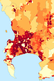 Population density in Cape Town
<1 /km²
1–3 /km²
3–10 /km²
10–30 /km²
30–100 /km²
100–300 /km²
300–1000 /km²
1000–3000 /km²
>3000 /km²
|
Economy
Cape Town is the economic hub of the Western Cape province, South Africa's second main economic centre and Africa's third main economic hub city. It serves as the regional manufacturing centre in the Western Cape. In 2011 the city's GDP was US$56.8 billion with a GDP per capita of US$15,721.[6] In the five years preceding 2014 Cape Town GDP grew at an average of 3.7% a year. As a proportion of GDP, the agriculture and manufacturing sectors have declined whilst finance, business services, transport and logistics have grown reflecting the growth in specialised services sectors of the local economy. Fishing, clothing and textiles, wood product manufacturing, electronics, furniture, hospitality, finance and business services are industries in which Cape Town's economy has the largest comparative advantage.[10]
Between 2001 and 2010 the city's Gini coefficient, a measure of inequality, improved by dropping from 0.59 in 2007 to 0.57 in 2010[10] only to increase to 0.58 by 2017.[68] The city has the lowest rate of inequality in South Africa.[69]
Cape Town has recently enjoyed a booming real estate and construction market, because of the 2010 FIFA World Cup as well as many people buying summer homes in the city or relocating there permanently. Cape Town hosted nine World Cup matches: Six first-round matches, one second-round match, one quarter final and one semifinal. The central business district is under an extensive urban renewal programme, with numerous new buildings and renovations taking place under the guidance of the Cape Town Partnership.[70]
Cape Town has four major commercial nodes, with Cape Town Central Business District containing the majority of job opportunities and office space. Century City, the Bellville/Tyger Valley strip and Claremont commercial nodes are well established and contain many offices and corporate headquarters as well. Most companies headquartered in the city are insurance companies, retail groups, publishers, design houses, fashion designers, shipping companies, petrochemical companies, architects and advertising agencies.[71] The most notable companies headquartered in the city are food and fashion retailer Woolworths,[72] supermarket chain Pick n Pay Stores and Shoprite,[73] New Clicks Holdings Limited, fashion retailer Foschini Group,[74] isp MWEB, Mediclinic International, etv, multi-national mass media giant Naspers, and financial services giant Sanlam.[75] Other notable companies include Belron (vehicle glass repair and replacement group operating worldwide), CapeRay (develops, manufactures and supplies medical imaging equipment for the diagnosis of breast cancer), Ceres Fruit Juices (produces fruit juice and other fruit based products), Coronation Fund Managers (third-party fund management company), ICS (was one of the largest meat processing and distribution companies in the world), Vida e Caffè (chain of coffee retailers), Capitec Bank (commercial bank in the Republic of South Africa). The city is a manufacturing base for several multi-national companies including, Johnson & Johnson, GlaxoSmithKline, Levi Strauss & Co., Adidas, Bokomo Foods, Yoco and Nampak.
Much of the produce is handled through the Port of Cape Town or Cape Town International Airport. Most major shipbuilding companies have offices and manufacturing locations in Cape Town.[76] The Province is also a centre of energy development for the country, with the existing Koeberg nuclear power station providing energy for the Western Cape's needs.
The Western Cape is an important tourist region in South Africa; the tourism industry accounts for 9.8% of the GDP of the province and employs 9.6% of the province's workforce. In 2010, over 1.5 million international tourists visited the area.[77]
With the highest number of successful Information Technology companies in Africa, Cape Town is an important centre for the industry on the continent. Growing at an annual rate of 8.5% and an estimated worth of R77 billion in 2010, nationwide the IT industry in Cape Town is becoming increasingly important to the city's economy.[78]
The city was recently named as the most entrepreneurial city in South Africa, with the percentage of Capetonians pursuing business opportunities almost three times higher than the national average. Those aged between 18 and 64 were 190% more likely to pursue new business, whilst in Johannesburg, the same demographic group was only 60% more likely than the national average to pursue a new business.[79] Cape Town has become the Silicon Valley of South Africa, hosting innovative tech startups such as Jumo, Yoco, Aerobotics, Luno and The Sun Exchange.[80]

Tourism
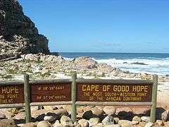
Cape Town is not only a popular international tourist destination in South Africa, but Africa as a whole. This is due to its mild climate, natural setting, and well-developed infrastructure. The city has several well-known natural features that attract tourists, most notably Table Mountain,[81] which forms a large part of the Table Mountain National Park and is the back end of the City Bowl. Reaching the top of the mountain can be achieved either by hiking up, or by taking the Table Mountain Cableway. Cape Point is recognised as the dramatic headland at the end of the Cape Peninsula.[82] Many tourists also drive along Chapman's Peak Drive, a narrow road that links Noordhoek with Hout Bay, for the views of the Atlantic Ocean and nearby mountains. It is possible to either drive or hike up Signal Hill for closer views of the City Bowl and Table Mountain.[83]
Many tourists also visit Cape Town's beaches, which are popular with local residents.[84] Due to the city's unique geography, it is possible to visit several different beaches in the same day, each with a different setting and atmosphere. Though the Cape's water ranges from cold to mild, the difference between the two sides of the city is dramatic. While the Atlantic Seaboard averages annual water temperatures barely above that of coastal California around 13 °C (55 °F), the False Bay coast is much warmer, averaging between 16 and 17 °C (61 and 63 °F) annually. This is similar to water temperatures in much of the Northern Mediterranean (for example Nice). In summer, False Bay water averages slightly over 20 °C (68 °F), with 22 °C (72 °F) a common high. Beaches located on the Atlantic Coast tend to have very cold water due to the Benguela current which originates from the Southern Ocean, whilst the water at False Bay beaches may be warmer by up to 10 °C (18 °F) at the same moment due to the influence of the warm Agulhas current.[84] It is a common misconception that False Bay is part of the Indian Ocean, with Cape Point being both the meeting point of the Indian and Atlantic Oceans, and the southernmost tip of Africa. The oceans in fact meet at the actual southernmost tip, Cape Agulhas, which lies approximately 150 kilometres (93 miles) to the south east. The misconception is fuelled by the relative warmth of the False Bay water to the Atlantic Seaboard water, and the many confusing instances of "Two Oceans" in names synonymous with Cape Town, such as the Two Oceans Marathon, the Two Oceans Aquarium, and places such as Two Oceans wine farm.
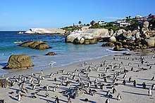
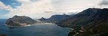
Both coasts are equally popular, although the beaches in affluent Clifton and elsewhere on the Atlantic Coast are better developed with restaurants and cafés, with a strip of restaurants and bars accessible to the beach at Camps Bay. The Atlantic seaboard, known as Cape Town's Riviera, is regarded as one of the most scenic routes in South Africa, along the slopes of the Twelve Apostles to the boulders and white sand beaches of Llandudno, which the route ending in Hout Bay, a diverse bustling suburb with a harbour and a seal island. This fishing village is flanked by the Constantia valley and the picturesque Chapman's Peak drive. Boulders Beach near Simon's Town is known for its colony of African penguins.[85] Surfing is popular and the city hosts the Red Bull Big Wave Africa surfing competition every year.
The city has several notable cultural attractions. The Victoria & Alfred Waterfront, built on top of part of the docks of the Port of Cape Town, is the city's most visited tourist attraction. It is also one of the city's most popular shopping venues, with several hundred shops and the Two Oceans Aquarium.[86][87] The V&A also hosts the Nelson Mandela Gateway, through which ferries depart for Robben Island.[88] It is possible to take a ferry from the V&A to Hout Bay, Simon's Town and the Cape fur seal colonies on Seal and Duiker Islands. Several companies offer tours of the Cape Flats, a mostly Coloured township, and Khayelitsha, a mostly black township.[89]
The most popular areas for visitors to stay include Camps Bay, Sea Point, the V&A Waterfront, the City Bowl, Hout Bay, Constantia, Rondebosch, Newlands, and Somerset West.[90]
In November 2013, Cape Town was voted the best global city in The Daily Telegraph's annual Travel Awards.[91]
Cape Town offers tourists a range of air, land and sea based adventure activities, including paragliding and skydiving.[92]
The City of Cape Town works closely with Cape Town Tourism to promote the city both locally and internationally. The primary focus of Cape Town Tourism is to represent Cape Town as a tourist destination.[93][94] Cape Town Tourism receives a portion of its funding from the City of Cape Town while the remainder is made up of membership fees and own-generated funds.[95]
The Tristan da Cunha government owns and operates a lodging facility in Cape Town which charges discounted rates to Tristan da Cunha residents and non-resident natives.[96]
 Clifton's 4th Beach
 Panoramic view across the Victoria Basin at the Victoria & Alfred Waterfront, with Table Mountain in the background
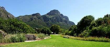 Kirstenbosch National Botanical Garden
 View over the City Bowl towards the Northern Suburbs
Culture
.jpg) Artscape Theatre Centre at Foreshore.
Artscape Theatre Centre at Foreshore. The distinctive Cape Malay Bo-Kaap is one of the most visited areas in Cape Town.
 Mostert's Mill
 Groote Kerk, Cape Town
Cape Town is noted for its architectural heritage, with the highest density of Cape Dutch style buildings in the world. Cape Dutch style, which combines the architectural traditions of the Netherlands, Germany, France and Indonesia, is most visible in Constantia, the old government buildings in the Central Business District, and along Long Street.[97][98] The annual Cape Town Minstrel Carnival, also known by its Afrikaans name of Kaapse Klopse, is a large minstrel festival held annually on 2 January or "Tweede Nuwe Jaar" (Afrikaans: Second New Year). Competing teams of minstrels parade in brightly coloured costumes, performing Cape Jazz, either carrying colourful umbrellas or playing an array of musical instruments. The Artscape Theatre Centre is the largest performing arts venue in Cape Town.[99]

The city also encloses the 36 hectare Kirstenbosch National Botanical Garden that contains protected natural forest and fynbos along with a variety of animals and birds. There are over 7,000 species in cultivation at Kirstenbosch, including many rare and threatened species of the Cape Floristic Region. In 2004 this Region, including Kirstenbosch, was declared a UNESCO World Heritage Site.[100]
Cape Town's transport system links it to the rest of South Africa; it serves as the gateway to other destinations within the province. The Cape Winelands and in particular the towns of Stellenbosch, Paarl and Franschhoek are popular day trips from the city for sightseeing and wine tasting.[101][102] Whale watching is popular amongst tourists: southern right whales and humpback whales are seen off the coast during the breeding season (August to November) and Bryde's whales and killer whale can be seen any time of the year.[103] The nearby town of Hermanus is known for its Whale Festival, but whales can also be seen in False Bay.[103] Heaviside's dolphins are endemic to the area and can be seen from the coast north of Cape Town; dusky dolphins live along the same coast and can occasionally be seen from the ferry to Robben Island.[103]
The only complete windmill in South Africa is Mostert's Mill, Mowbray. It was built in 1796 and restored in 1935 and again in 1995.
Crime
.jpg)
In recent years, the city has struggled with problems such as drugs, a surge in violent drug-related crime and more recently gang violence. In the Cape Flats alone, there are approximately 100,000 people in over 130 different gangs in 2018. While there are some alliances, this multitude and division is also cause for conflict between groups.[104] At the same time, the economy has grown due to the boom in the tourism and the real estate industries.[105] With a Gini coefficient of 0.58,[68] Cape Town had the lowest inequality rate in South Africa in 2012.[69] Between 2015 and 2018 Cape Town experienced a severe water shortage that resulted in temporary but widespread water rationing. Since July 2019 widespread violent crime in poorer gang dominated areas of greater Cape Town has resulted in an ongoing military presence in these neighbourhoods.[106][107] Cape Town had the highest murder rate among large South African cities at 77 murders per 100,000 people in the period April 2018 to March 2019, with 3157 murders mostly occurring in poor townships created under the apartheid regime.[108] On the 27th of July 2019 a Ukrainian tourist by the name of Ivan Ivanov was stabbed to death during a robbery while hiking just off Chapman's Peak Drive on Table Mountain.[109][110]
Places of worship

Most places of worship in the city are Christian churches and cathedrals: Zion Christian Church, Apostolic Faith Mission of South Africa, Assemblies of God, Baptist Union of Southern Africa (Baptist World Alliance), Methodist Church of Southern Africa (World Methodist Council), Anglican Church of Southern Africa (Anglican Communion), Presbyterian Church of Africa (World Communion of Reformed Churches), Roman Catholic Archdiocese of Cape Town (Catholic Church).[111] Islam is the city's second largest religion with a long history in Cape Town[112] resulting in a number of mosques and other Muslim religious sites spread across the city[113] such as the Auwal Mosque South Africa's first mosque. Cape Town's significant Jewish population supports a number of synagogues most notably the historic Gardens Shul. The Cape Town Progressive Jewish Congregation (CTPJC) also has three temples in the city. Other religious sites in the city include Hindu, Buddhist and Baha'i temples.
Media
Several newspapers, magazines and printing facilities have their offices in the city. Independent News and Media publishes the major English language papers in the city, the Cape Argus and the Cape Times. Naspers, the largest media conglomerate in South Africa, publishes Die Burger, the major Afrikaans language paper.[114]
Cape Town has many local community newspapers. Some of the largest community newspapers in English are the Athlone News from Athlone, the Atlantic Sun, the Constantiaberg Bulletin from Constantiaberg, the City Vision from Bellville, the False Bay Echo from False Bay, the Helderberg Sun from Helderberg, the Plainsman from Michell's Plain, the Sentinel News from Hout Bay, the Southern Mail from the Southern Peninsula, the Southern Suburbs Tatler from the Southern Suburbs, Table Talk from Table View and Tygertalk from Tygervalley/Durbanville. Afrikaans language community newspapers include the Landbou-Burger and the Tygerburger. Vukani, based in the Cape Flats, is published in Xhosa.[115]
Cape Town is a centre for major broadcast media with several radio stations that only broadcast within the city. 94.5 Kfm (94.5 MHz FM) and Good Hope FM (94–97 MHz FM) mostly play pop music. Heart FM (104.9 MHz FM), the former P4 Radio, plays jazz and R&B, while Fine Music Radio (101.3 FM) plays classical music and jazz. Bush Radio is a community radio station (89.5 MHz FM). The Voice of the Cape (95.8 MHz FM) and Cape Talk (567 kHz MW) are the major talk radio stations in the city.[116] Bokradio (98.9 MHz FM) is an Afrikaans music station.[117] The University of Cape Town also runs its own radio station, UCT Radio (104.5 MHz FM).
The SABC has a small presence in the city, with satellite studios located at Sea Point. e.tv has a greater presence, with a large complex located at Longkloof Studios in Gardens. M-Net is not well represented with infrastructure within the city. Cape Town TV is a local TV station, supported by numerous organisation and focusing mostly on documentaries. Numerous productions companies and their support industries are located in the city, mostly supporting the production of overseas commercials, model shoots, TV-series and movies.[118] The local media infrastructure remains primarily in Johannesburg.
Sport

| Venue | Sport | Capacity | Club(s) |
|---|---|---|---|
| Cape Town Stadium | Association football/Rugby | 55,000 | Ajax CT, Cape Town City FC |
| Newlands Cricket Ground | Cricket | 25,000 | Cape Cobras, Western Province Cricket |
| Newlands Rugby Stadium | Rugby | 47,000 | Stormers, Western Province |
| Athlone Stadium | Association football | 24,000 | Santos Football Club |
| Philippi Stadium | Association football | 5,000 | |
| Bellville Velodrome | Cycling track | 3,000 | Western Province Cycling |
| Hartleyvale Hockey Centre | Field Hockey | 2,000 | Western Province Hockey |
| Turfhall Stadium | Softball | 3,000 | Western Province Softball |
| Good Hope Centre | Various indoor sports | 6,000 | Various |
| Royal Cape Yacht Club | Sailing | N/A | Royal Cape Yacht Club |
| Grand West Arena | Various | 6,000 | N/A |
| Green Point Athletics Stadium | Athletics, Association football | 5,000 | N/A |
| Newlands Swimming Pool | Swimming/water polo/diving | 2,000 | WP Aquatics |
| Autshumato/Berg River Dam | Rowing/Canoe-Kayak | N/A | N/A |
| Khayelitsha canal | Rowing/Canoe | ||
| Khayelitsha Rugby & Soccer stadium | Association football/Rugby | 6,000 |
Cape Town's most popular sports by participation are cricket, association football, swimming, and rugby union.[119] In rugby union, Cape Town is the home of the Western Province side, who play at Newlands Stadium and compete in the Currie Cup. In addition, Western Province players (along with some from Wellington's Boland Cavaliers) comprise the Stormers in the Southern Hemisphere's Super Rugby competition. Cape Town also regularly hosts the national team, the Springboks, and hosted matches during the 1995 Rugby World Cup, including the opening ceremony and game, as well as the semi-final between New Zealand and England that saw Jonah Lomu run in four tries.
Association football, which is also known as soccer in South Africa, is also popular. Two clubs from Cape Town play in the Premier Soccer League (PSL), South Africa's premier league. These teams are Ajax Cape Town, which formed as a result of the 1999 amalgamation of the Seven Stars and the Cape Town Spurs and resurrected Cape Town City F.C. Cape Town was also the location of several of the matches of the FIFA 2010 World Cup including a semi-final,[120] held in South Africa. The Mother City built a new 70,000 seat stadium (Cape Town Stadium) in the Green Point area.
In cricket, the Cape Cobras represent Cape Town at the Newlands Cricket Ground. The team is the result of an amalgamation of the Western Province Cricket and Boland Cricket teams. They take part in the Supersport and Standard Bank Cup Series. The Newlands Cricket Ground regularly hosts international matches.
Cape Town has had Olympic aspirations. For example, in 1996, Cape Town was one of the five candidate cities shortlisted by the IOC to launch official candidatures to host the 2004 Summer Olympics. Although the Games ultimately went to Athens, Cape Town came in third place. There has been some speculation that Cape Town was seeking the South African Olympic Committee's nomination to be South Africa's bid city for the 2020 Summer Olympic Games.[121] That however was quashed when the International Olympic Committee awarded the 2020 Games to Tokyo.
Sports events
The city of Cape Town has vast experience in hosting major national and international sports events.
The Cape Town Cycle Tour is the world's largest individually timed cycle race – and the first event outside Europe to be included in the International Cycling Union's Golden Bike Series. It sees over 35,000 cyclists tackling a 109 km (68 mi) route around Cape Town. The Absa Cape Epic is the largest full-service mountain bike stage race in the world.
Some notable events hosted by Cape Town have included the 1995 Rugby World Cup, 2003 ICC Cricket World Cup, and World Championships in various sports such as athletics, fencing, weightlifting, hockey, cycling, canoeing, gymnastics and others.
Cape Town was also a host city to the 2010 FIFA World Cup from 11 June to 11 July 2010, further enhancing its profile as a major events city. It was also one of the host cities of the 2009 Indian Premier League cricket tournament.
Education
Public primary and secondary schools in Cape Town are run by the Western Cape Education Department. This provincial department is divided into seven districts; four of these are "Metropole" districts – Metropole Central, North, South, and East – which cover various areas of the city.[122] There are also many private schools, both religious and secular, in Cape Town.
Tertiary education
Cape Town has a well-developed higher system of public universities. Cape Town is served by three public universities: the University of Cape Town (UCT), the University of the Western Cape (UWC) and the Cape Peninsula University of Technology (CPUT). Stellenbosch University, while not in the city itself, is 50 kilometres from the City Bowl and has additional campuses, such as the Tygerberg Faculty of Medicine and Health Sciences and the Bellville Business Park closer to the City.
Both the University of Cape Town and Stellenbosch University are leading universities in South Africa. This is due in large part to substantial financial contributions made to these institutions by both the public and private sector. UCT is an English-speaking institution. It has over 21,000 students and has an MBA programme that is ranked 51st by the Financial Times in 2006.[123] It is also the top-ranked university in Africa, being the only African university to make the world's Top 200 university list at number 146.[124] Since the African National Congress has come into governmental power, some restructuring of Western Cape universities has taken place and as such, traditionally non-white universities have seen increased financing, which has benefitted the University of the Western Cape.[125][126]
The public Cape Peninsula University of Technology was formed on 1 January 2005, when two separate institutions – Cape Technikon and Peninsula Technikon – were merged. The new university offers education primarily in English, although one may take courses in any of South Africa's official languages. The institution generally awards the National Diploma.
Cape Town has also become a popular study abroad destination for many international college students. Many study abroad providers offer semester, summer, short-term, and internship programs in partnership with Cape Town universities as a chance for international students to gain intercultural understanding.
Transport
Air
.JPG)
Cape Town International Airport serves both domestic and international flights. It is the second-largest airport in South Africa and serves as a major gateway for travelers to the Cape region. Cape Town has regularly scheduled services to Southern Africa, East Africa, Mauritius, Middle East, Far East, Europe and the United States as well as eleven domestic destinations.[127]
Cape Town International Airport recently opened a brand new central terminal building that was developed to handle an expected increase in air traffic as tourism numbers increased in the lead-up to the 2010 FIFA World Cup.[128] Other renovations include several large new parking garages, a revamped domestic departure terminal, a new Bus Rapid Transit system station and a new double-decker road system. The airport's cargo facilities are also being expanded and several large empty lots are being developed into office space and hotels.
The Cape Town International Airport was among the winners of the World Travel Awards for being Africa's leading airport.[129]
Cape Town International Airport is located 18 km from the Central Business District[130]
Sea
Cape Town has a long tradition as a port city. The Port of Cape Town, the city's main port, is in Table Bay directly to the north of the CBD. The port is a hub for ships in the southern Atlantic: it is located along one of the busiest shipping corridors in the world. It is also a busy container port, second in South Africa only to Durban. In 2004, it handled 3,161 ships and 9.2 million tonnes of cargo.[131]
Simon's Town Harbour on the False Bay coast of the Cape Peninsula is the main operational base of the South African Navy.
Until the 1970s the city was served by the Union Castle Line with service to the United Kingdom and St Helena.[132] The RMS St Helena provided passenger and cargo service between Cape Town and St Helena until the opening of St Helena Airport.[133]
Currently the cargo vessel M/V Helena, under AW Shipping Management, takes a limited number of passengers,[134] between Cape Town and St Helena and Ascension Island on its voyages.[135] Multiple vessels also take passengers to and from Tristan da Cunha, inaccessible by aircraft, to and from Cape Town.[136] In addition NSB Niederelbe Schiffahrtsgesellschaft takes passengers on its cargo service to the Canary Islands and Hamburg, Germany.[134]
Rail
The Shosholoza Meyl is the passenger rail operations of Spoornet and operates two long-distance passenger rail services from Cape Town: a daily service to and from Johannesburg via Kimberley and a weekly service to and from Durban via Kimberley, Bloemfontein and Pietermaritzburg. These trains terminate at Cape Town railway station and make a brief stop at Bellville. Cape Town is also one terminus of the luxury tourist-oriented Blue Train as well as the five-star Rovos Rail.
Metrorail operates a commuter rail service in Cape Town and the surrounding area. The Metrorail network consists of 96 stations throughout the suburbs and outskirts of Cape Town.
Road
Cape Town is the origin of three national roads. The N1 and N2 begin in the foreshore area near the City Center.
The N1 runs East-North-East through Edgemead, Parow, Bellville, and Brackenfell. It connects Cape Town to major cities further inland, namely Bloemfontein, Johannesburg, and Pretoria An older at-grade road, the R101, runs parallel to the N1 from Bellville.
.jpg)
The N2 runs East-South-Ease through Rondebosch, Guguletu, Khayelitsha, Macassar to Somerset West. It becomes a multiple-carriageway at-grade road from the intersection with the R44 onwards. The N2 continues east along the coast, linking Cape Town to the coastal cities of Port Elizabeth, East London and Durban. An older at-grade road, the R101, runs parallel to the N1 initially, before veering south at Bellville, to join the N2 at Somerset West via the suburbs of Kuils River and Eerste River.
The N7 originates from the N1 at Wingfield Interchange near Edgemead. It runs north, initially as a highway, but becoming an at-grade road from the intersection with the M5 (Potsdam Rd) onwards. It links Cape Town with towns further North and eventually, Namibia.
There are also a number of regional routes linking Cape Town with surrounding areas. The R27 originates from the N1 near the Foreshore and runs north parallel to the N7, but nearer to the coast. It passes through the suburbs of Milnerton, Table View and Bloubergstrand and links the City to the West Coast, ending at the town of Velddrif. The R44 enters the east of the metro from the north, from Stellenbosch. It connects Stellenbosch to Somerset West, then crosses the N2 to Strand and Gordon's Bay. It exits the metro heading south hugging the coast, leading to the towns of Betty's Bay and Kleinmond.
Of the three-digit routes, the R300, is an expressway linking the N1 at Brackenfell to the N2 near Mitchells Plain and the Cape Town International Airport. The R302 runs from the R102 in Bellville, heading north across the N1 through Durbanville leaving the metro to Malmesbury. The R304 enters the northern limits of the metro from Stellenbosch, running NNW before veering west to cross the N7 at Philadelphia to end at Atlantis at a junction with the\sR307. This R307 starts north of Koeberg from the R27 and, after meeting the R304, continues north to Darling. The R310 originates from Muizenberg and runs along the coast, to the south of Mitchell's Plain and Khayelitsha, before veering north-east, crossing the N2 west of Macassar, and exiting the metro heading to Stellenbosch.
Cape Town, like most South African cities, uses Metropolitan or "M" routes for important intra-city routes, a layer below National (N) roads and Regional (R) routes. Each city's M roads are independently numbered. Most are at-grade roads. However, the M3 splits from the N2 and runs to the south along the eastern slopes of Table Mountain, connecting the City Bowl with Muizenberg. Except for a section between Rondebosch and Newlands that has at-grade intersections, this route is a highway. The M5 splits from the N1 further east than the M3, and links the Cape Flats to the CBD. It is a highway as far as the interchange with the M68 at Ottery, before continuing as an at-grade road.
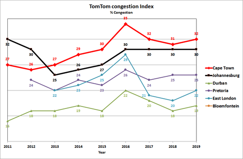
Cape Town suffers from the worst traffic congestion in South Africa.[137][138]
Buses
Golden Arrow Bus Services operates scheduled bus services in the Cape Town metropolitan area. Several companies run long-distance bus services from Cape Town to the other cities in South Africa.
Integrated Rapid Transit (IRT)
Cape Town has a public transport system in about 10% of the city, running north to south along the west coastline of the city, comprising Phase 1 of the IRT system. This is known as the MyCiTi service.[139]
MyCiTi Phase 1 includes services linking the Airport to the Cape Town inner city, as well as the following areas: Blouberg / Table View, Dunoon, Atlantis and Melkbosstrand, Milnerton, Paarden Eiland, Century City, Salt River and Walmer Estate, and all suburbs of the City Bowl and Atlantic Seaboard all the way to Llandudno and Hout Bay.
The MyCiTi N2 Express service consists of two routes each linking the Cape Town inner city and Khayelitsha and Mitchells Plain on the Cape Flats.
The service use high floor articulated and standard size buses in dedicated busways, low floor articulated and standard size buses on the N2 Express service, and smaller 9-metre (30-foot) Optare buses in suburban and inner city areas. It offers universal access through level boarding and numerous other measures, and requires cashless fare payment using the EMV compliant smart card system, called myconnect. Headway of services (i.e. the time between buses on the same route) range from 3 mins to 20 mins in peak times to 60 minutes during quiet off-peak periods.
Taxis
Cape Town has two kinds of taxis: metered taxis and minibus taxis. Unlike many cities, metered taxis are not allowed to drive around the city to solicit fares and instead must be called to a specific location.
Cape Town metered taxi cabs mostly operate in the city bowl, suburbs and Cape Town International Airport areas. Large companies that operate fleets of cabs can be reached by phone and are cheaper than the single operators that apply for hire from taxi ranks and Victoria and Alfred Waterfront. There are about one thousand meter taxis in Cape Town. Their rates vary from R8 per kilometre to about R15 per kilometre. The larger taxi companies in Cape Town are Excite Taxis, Cabnet and Intercab and single operators are reachable by cellular phone. The seven seated Toyota Avanza are the most popular with larger Taxi companies. Meter cabs are mostly used by tourists and are safer to use than minibus taxis.
Minibus taxis are the standard form of transport for the majority of the population who cannot afford private vehicles.[140] Although essential, these taxis are often poorly maintained and are frequently not road-worthy. These taxis make frequent unscheduled stops to pick up passengers, which can cause accidents.[141][142] With the high demand for transport by the working class of South Africa, minibus taxis are often filled over their legal passenger allowance. Minibuses are generally owned and operated in fleets.[143]
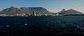 Table Mountain from the harbour
 Metrorail train leaving Kalk Bay station
 N2 highway, entering the City Bowl
 Taxi rank above Cape Town railway station
 Cape Town City Sight Seeing Bus
International relations
Cape Town currently has seventeen active sister city agreements [144]


See also
- Outline of Cape Town
- OPENCities
References
- "City of Cape Town announces new city manager". News24. 26 April 2018. Archived from the original on 15 August 2019. Retrieved 5 February 2019.
- "Main Place Cape Town". Census 2011. Archived from the original on 21 April 2016. Retrieved 22 March 2019.
- "City of Cape Town Metropolitan Municipality". Archived from the original on 22 December 2018. Retrieved 22 December 2018.
- "City of Cape Town". Archived from the original on 22 December 2018. Retrieved 22 December 2018.
- "2016 Community Survey". Archived from the original on 20 July 2013. Retrieved 19 February 2016.
- "Global city GDP 2011". Brookings Institution. Archived from the original on 5 June 2013. Retrieved 18 November 2014.
- "Discover the 9 Provinces of South Africa and their Capital Cities". Archived from the original on 14 June 2017. Retrieved 22 June 2017.
- "Western Cape | province, South Africa". Encyclopedia Britannica. Archived from the original on 8 May 2017. Retrieved 22 June 2017.
- "Pretoria | national administrative capital, South Africa". Encyclopedia Britannica. Archived from the original on 18 July 2018. Retrieved 18 July 2018.
- Morris, Michael (21 November 2014). "Highlights from the State of the City 2014 report". Weekend Argus. Archived from the original on 15 March 2015. Retrieved 23 November 2014.
- "Cape Town Hosts Official WDC 2014 Signing Ceremony". World Design Capital. Archived from the original on 10 March 2013. Retrieved 4 August 2012.
- "14 Fun Facts You Didn't Know About Cape Town - Interesting & Amusing Things about the Mother City". Cape Town Magazine. Archived from the original on 26 June 2014. Retrieved 17 June 2014.
- Bruyn, Pippa de (5 February 2016). "The world's best cities". Telegraph.co.uk. Archived from the original on 5 January 2016. Retrieved 4 April 2018.
- "The Antiquity of man". SouthAfrica.info. Archived from the original on 1 March 2009. Retrieved 15 June 2009.
- Hamilton, Carolyn, (ed.) Mbenga, Bernard, (ed.) Ross, Robert, 1949 July 26- (ed.) (2011). "Khoesan and Immigrants". The Cambridge history of South Africa: 1885-1994. 1. Cambridge University Press. pp. 168–173. ISBN 9780521517942. OCLC 778617810.CS1 maint: multiple names: authors list (link) CS1 maint: extra text: authors list (link)
- "Cape-Slavery-Heritage " Coloured People of the Western Cape have the most Diverse Ancestry in the World :: iBlog". Cape-slavery-heritage.iblog.co.za. 1 May 2009. Retrieved 17 March 2011.
- "Slavery and early colonisation, South African History Online". Sahistory.org.za. 22 September 1927. Archived from the original on 9 January 2011. Retrieved 17 March 2011.
- Pooley, S. ‘Jan van Riebeeck as Pioneering Explorer and Conservator of Natural Resources at the Cape of Good Hope (1652–62),’ Environment and History 15 (2009): 3–33. doi:10.3197/096734009X404644
- Bell, Charles. "A painting of the arrival of Jan van Riebeeck in Table Bay". Archived from the original on 30 December 2011. Retrieved 11 April 2011.
- McCracken, J.L. The Cape Parliament, 1854-1910. Clarendon Press, Oxford, 1967.
- Carruthers, Jane; Robin, Libby (23 March 2010). "Taxonomic imperialism in the battles for Acacia:Identity and science in South Africa and Australia". Transactions of the Royal Society of South Africa. 65 (1): 60. doi:10.1080/00359191003652066.
- "A Contested Past and Present: Australian Trees in South Africa". Social Science Research Council. Retrieved 12 February 2020.
- Mbenga, Bernard. "New History of South Africa". Tafelberg, South Africa, 2007. Archived from the original on 22 April 2014. Retrieved 18 January 2013.
- Halkett, D.J. (October 2012). "ARCHAEOLOGICAL ASSESSMENT OF THE PROPOSED CAPE TOWN INTERNATIONAL CONVENTION CENTRE 2 ON ERWEN 192, 245, 246 AND THE REMAINDER OF ERF 192, "SALAZAR SQUARE", ROGGEBAAI, CAPE TOWN FORESHORE" (PDF). sahra.org.za. p. 18. Retrieved 26 August 2019.
- Bickford-Smith, Vivian (1995). "South African Urban History, Racial Segregation and the Unique Case of Cape Town?". Journal of Southern African Studies. 21 (1): 63–78. doi:10.1080/03057079508708433. ISSN 0305-7070. JSTOR 2637331.
- Adhikari, Mohamed (2009). Burdened by race: Coloured identities in southern Africa. Cape Town: UCT Press. p. 51. ISBN 978-1-92051-660-4. Archived from the original on 20 July 2018. Retrieved 26 August 2019.
- "Recalling District Six". SouthAfrica.info. 19 August 2003. Archived from the original on 11 February 2012. Retrieved 13 June 2006.
- Sash, Black (3 November 1983). ""The Coloured Labour Preference Area Policy"- Paper Presented by Cape Western Region to National Conference 1983". National texts, 1955-1994. Retrieved 16 December 2019.
- "Cape Schools Join the Revolt - South African History Online". Archived from the original on 14 July 2014. Retrieved 16 June 2014.
- "Western Cape Youth Uprising timeline 1976 - South African History Online". Archived from the original on 4 August 2014. Retrieved 16 June 2014.
- "Robben Island". South African History Online. 14 July 2011. Archived from the original on 1 April 2019. Retrieved 24 July 2019.
- Robinson, Peter J.; Henderson-Sellers, Ann (1999). Contemporary Climatology. Harlow: Pearson Education Limited. p. 123. ISBN 9780582276314.
- Rohli, Robert V.; Vega, Anthony J. (2011). Climatology. Sudbury, MA: Jones & Bartlett Learning. p. 250. ISBN 9781449649548. Archived from the original on 21 November 2016. Retrieved 27 January 2016.
- "Cape Point (South Africa)". Global Atmosphere Watch Station Information System (GAWSIS). Federal Office of Meteorology and Climatology MeteoSwiss. Archived from the original on 27 August 2013. Retrieved 20 May 2014.
climate zone – Csb (Warm temperate climate with dry and warm summer)
- "World Weather Information Service – Cape Town". Archived from the original on 26 April 2010. Retrieved 4 May 2010.
- "Cape Town/DF Malan Climate Normals 1961–1990". National Oceanic and Atmospheric Administration. Retrieved 8 April 2013.
- "Climate data: Cape Town". Old.weathersa.co.za. 28 October 2003. Archived from the original on 14 March 2011. Retrieved 17 March 2011.
- "Hottest temperature". enca.com. Archived from the original on 20 July 2015. Retrieved 6 March 2015.
- "Brochures, booklets and posters". Capetown.gov.za. Archived from the original on 23 December 2012. Retrieved 1 October 2011.
- "Unique Biodiversity Poster" (PDF). Archived from the original (PDF) on 25 July 2012. Retrieved 6 February 2013.
- Cape Town Tourism. "Vote for Table Mountain – Cape Town Tourism". Capetown.travel. Archived from the original on 12 January 2012. Retrieved 12 January 2013.
- "Western Cape". Southafricaholiday.org.uk. Archived from the original on 10 December 2012. Retrieved 12 January 2013.
- A.G. Rebelo, C. Boucher, N. Helme, L. Mucina, M.C. Rutherford et al. 2006. Fynbos Biome, in: L. Mucina & M.C. Rutherford (eds). The Vegetation of South Africa, Lesotho and Swaziland.
- "National Spatial Biodiversity Assessment 2005 Targets". Capetown.gov.za. Archived from the original on 24 August 2013. Retrieved 24 February 2014.
- "Endemic Species of the city of Cape Town" (PDF). Archived from the original (PDF) on 1 November 2011.
- "The View from The Cape: Extinction Risk, Protected Areas, and Climate Change" (PDF). Perceval.bio.nau.edu. Archived from the original (PDF) on 25 August 2013. Retrieved 24 February 2014.
- "Congratulations! Cape Town claims the top spot in the international City Nature Challenge 2019". 7 May 2019. Archived from the original on 5 August 2019. Retrieved 5 August 2019.
- Rebelo, Tony (12 June 2019). "And we feature again!!! Cape Town in the forefront ..." iNaturalist. Archived from the original on 5 August 2019. Retrieved 5 August 2019.
- Axelson, Eric. "Cape Town. National Legislative Capital, South Africa". ENCYCLOPÆDIA BRITANNICA. Retrieved 31 March 2020.
- Muller, Joan. "Joburg has the cash, Cape Town the class". BDLive. Business Day. Archived from the original on 18 January 2014. Retrieved 15 January 2014.
- Editor. "Tygerberg Hospital: Overview". Western Cape Department of Health. Western Cape Government. Archived from the original on 16 January 2014. Retrieved 15 January 2014.CS1 maint: extra text: authors list (link)
- Thompson, Andrew. "How Cape Dutch Architecture Is Central to Cape Town's Past". theculturetrip.com. The Culture Trip Ltd. Retrieved 9 June 2019.
- Editor. "History of the South African Navy". SA Navy. SA Navy. Archived from the original on 23 February 2008. Retrieved 15 January 2014.CS1 maint: extra text: authors list (link)
- "Groundwater Model Report Vol. 5 Cape Flats Aquifer Model" (PDF). Department of Water Affairs.
- Piombo, J. (3 August 2009). Institutions, Ethnicity, and Political Mobilization in South Africa. Springer. ISBN 978-0-230-62382-8.
- Anciano, Fiona; Piper, Laurence (3 October 2018). Democracy Disconnected: Participation and Governance in a City of the South. Routledge. ISBN 978-0-429-79429-2.
- "Seat Calculation Detail: City of Cape Town" (PDF). Independent Electoral Commission. 21 May 2011. Archived (PDF) from the original on 26 June 2011. Retrieved 23 May 2011.
- "Dan Plato Replaces De Lille". Cape Times. 19 September 2018 – via ProQuest.
- Worden, Nigel; van Hyningen, Elizabeth; Bickford-Smith, Vivian (1998). Cape Town: The Making of a City. Claremont, Cape Town, South Africa: David Philip Publishers. p. 212. ISBN 0-86486-435-3.
- "Population estimates for Cape Town, South Africa, 1950-2015". Mongabay.com. Archived from the original on 1 November 2014. Retrieved 23 July 2014.
- "Census 96 : Community Profile". City of Cape Town. Archived from the original on 26 July 2014. Retrieved 23 July 2014.
- "City of Cape Town – 2011 Census – Cape Town" (PDF). City of Cape Town. Archived from the original (PDF) on 3 December 2013. Retrieved 23 July 2014.
- Small, Karen (December 2008). "Demographic and Socio-economic Trends for Cape Town: 1996 to 2007" (PDF). City of Cape Town. Archived from the original (PDF) on 3 March 2016. Retrieved 23 July 2014.
- "Cape Town Population 2018 (Demographics, Maps, Graphs)". worldpopulationreview.com. 3 July 2018. Archived from the original on 3 July 2018. Retrieved 3 July 2018.
- Census 2011 Municipal report: Western Cape. Statistics South Africa. 2012. ISBN 978-0-621-41459-2. Retrieved 30 November 2016.
- Rebekah Lee (2009). "African women and apartheid: migration and settlement in urban South Africa". I.B. Tauris. p.205. ISBN 1-84511-819-7
- Western Cape Government (2017). "SEP Socio-Economic Profile: City of Cape Town" (PDF). www.westerncape.gov.za. Archived (PDF) from the original on 16 February 2019.
- "Cape Town least unequal SA city - Politics | IOL News". IOL.co.za. 4 December 2012. Archived from the original on 12 January 2014. Retrieved 24 February 2014.
- "Cape Town Guide". capetownattractions.com. Archived from the original on 10 August 2015.
- Editor. "Economic Development". City of Cape Town: Economic Statistics. City of Cape Town. Archived from the original on 16 January 2014. Retrieved 15 January 2014.CS1 maint: extra text: authors list (link)
- Editor. "Media Contact". Woolworths. Woolworths Holdings Limited. Archived from the original on 2 January 2014. Retrieved 15 January 2014.CS1 maint: extra text: authors list (link)
- EMIS. "Pick n Pay Holdings Ltd". Emerging Markets Information Service. EMIS. Archived from the original on 17 April 2014. Retrieved 15 January 2014.,
- Editor. "Contact Us". Foshini Group. Foschini. Archived from the original on 16 January 2014. Retrieved 15 January 2014.CS1 maint: extra text: authors list (link)
- Editor. "Who We Are". Sanlam. Sanlam. Archived from the original on 16 January 2014. Retrieved 15 January 2014.CS1 maint: extra text: authors list (link)
- "South African Boatbuilders Business Council". Southafricanboatbuilders.co.za. Archived from the original on 6 January 2017. Retrieved 24 February 2014.
- Annual Report 2010 (PDF). Cape Town Routes Unlimited. ISBN 0-621-35496-1. Archived from the original on 15 September 2011. Retrieved 3 June 2012.
- "Cape Town Leads In Information Technology". 27 March 2007. Archived from the original on 29 July 2012. Retrieved 24 February 2014.
- "Cape Town breeds entrepreneurs: Fin24: Business". Fin24. 7 September 2008. Archived from the original on 26 January 2009. Retrieved 1 October 2011.
- "Eight SA startups to look out for in 2019". Venture Burn.
- "Table Mountain Aerial Cableway". Archived from the original on 18 December 2014. Retrieved 21 April 2008.
- "Cape Point". Cape Point. Archived from the original on 28 September 2011. Retrieved 1 October 2011.
- "South Africa National Botanical Gardens Archived 6 October 2017 at the Wayback Machine" .Vibescout.com. Retrieved 4 October 2017
- "Beaches, Cape Town, South Africa". Safarinow.com. Archived from the original on 3 September 2015. Retrieved 1 October 2011.
- "The African Penguin". Simonstown.com. Archived from the original on 2 November 2013. Retrieved 24 February 2014.
- "V&A Waterfront". Waterfront.co.za. Archived from the original on 9 November 2013. Retrieved 1 October 2011.
- Ingrid Sinclair (30 September 2011). "Two Oceans Aquarium Cape Town, South Africa". Aquarium.co.za. Archived from the original on 28 September 2011. Retrieved 1 October 2011.
- "Robben Island Museum". Robben-island.org.za. 2 May 2011. Archived from the original on 4 October 2011. Retrieved 1 October 2011.
- Archived 10 February 2010 at the Wayback Machine
- "Cape Town Tourism Statistics". Cape Town Direct. Archived from the original on 7 November 2006.
- "Telegraph Travel Awards 2013: Favourite cities". The Daily Telegraph. London. 27 November 2013. Archived from the original on 2 December 2013. Retrieved 4 December 2013.
- Cape Town Tourism capetown.travel, retrieved 26 Dec 2019
- "Tenant of the month: Cape Town Tourism". www.citysightseeing.co.za. Archived from the original on 4 June 2016. Retrieved 9 May 2016.
- "CT Tourism celebrates tenth birthday". Fin24. Archived from the original on 4 June 2016. Retrieved 9 May 2016.
- "Cape Town Tourism dealt budget cut blow". News24. Archived from the original on 20 December 2016. Retrieved 9 May 2016.
- "Tristan da Cunha Accommodation". Tristan da Cunha Government & Tristan da Cunha Association. Retrieved 6 January 2020.
- "Cape Dutch Architecture". Encounter South Africa. Archived from the original on 18 June 2006. Retrieved 14 June 2006.
- Dewar, David; Hutton-Squire, Martin; Levy, Caren; Menidis, Philip; Uytenbogaardt, Roelof (1977). A Comparative Evaluation of Urbanism in Cape Town. University of Cape Town Press. pp. 20–98. ISBN 0-620-02535-2.
- "Artscape Theatre Centre". www.timeout.com. Archived from the original on 31 July 2017.
- "Kirstenbosch National Botanical Garden". Sanbi.org. Archived from the original on 29 September 2011. Retrieved 1 October 2011.
- "Cape Winelands". Tourismcapewinelands.co.za. Archived from the original on 24 September 2004. Retrieved 24 February 2014.
- "The Western Cape wine lands". Winelands.co.za. Archived from the original on 14 February 2014. Retrieved 24 February 2014.
- "Cape Town Whale Watching". Afton Grove. Archived from the original on 22 April 2006.
- "Why Cape Town's murder rate is rising". The Economist. Archived from the original on 9 October 2018. Retrieved 10 October 2018.
- Jeffreys, Andrew (ed.). "Caps off to the Western Cape". The Report: South Africa 2008. Oxford Business Group. p. 159. ISBN 978-1-9023-3979-5. Retrieved 23 July 2019.
- "South Africa Deploys Army to Gang-Hit Cape Town" (12 July 2019). BBC News. Retrieved 17 April 2020.
- "Archived copy". Archived from the original on 23 September 2019. Retrieved 24 September 2019.CS1 maint: archived copy as title (link)
- https://issafrica.org/crimehub/maps/municipal-districts
- "son of ukrainian hiker murdered chapmans peak will never visit sa". iol.co.za. Retrieved 24 January 2020.
- "Ukraine tourist murdered in hout bay". capetalk. Retrieved 24 January 2020.
- Britannica, SouthAfrica Archived 29 June 2019 at the Wayback Machine, britannica.com, USA, accessed on July 7, 2019
- tinashe (13 January 2012). "History of Muslims in South Africa: 1652 - 1699 by Ebrahim Mahomed Mahida". South African History Online. Archived from the original on 10 January 2019. Retrieved 23 August 2019.
- "Mosques – Cape Town Muslims". capetownmuslims.co.za. Archived from the original on 21 January 2019. Retrieved 23 August 2019.
- "South Africa Newspapers". ABYZ News Links. Archived from the original on 26 February 2014. Retrieved 24 February 2014.
- "South Africa Newspapers". Daily Earth. Archived from the original on 29 August 2013. Retrieved 24 February 2014.
- "Radio companies". BizCommunity.Com. Archived from the original on 18 January 2010. Retrieved 24 February 2014.
- "98.9fm". Bok Radio. 20 June 2013. Archived from the original on 28 February 2014. Retrieved 24 February 2014.
- "South African Industry News". filmmakersguide.co.za. Archived from the original on 17 February 2010. Retrieved 24 February 2014.
- Woulidge, Sam (2006). Time Out: Cape Town. Time Out Publishing. pp. 127–130: Sports. ISBN 1-904978-12-6.
- "SA 2010: frequent questions". southafrica.info. Archived from the original on 3 June 2007. Retrieved 26 May 2007.
- South Africa Announces Bid For 2020 Summer Olympic Games Archived 13 June 2008 at the Wayback Machine, Gamesbids.com
- "Education Management and Development Centres (EMDCs)". Western Cape Education Department. Archived from the original on 9 April 2008. Retrieved 10 April 2008.
- "Competitiveness factors". City of Cape Town. Archived from the original on 27 September 2007.
- "University of cape town". Top Universities. 12 November 2009. Archived from the original on 20 February 2010. Retrieved 2 July 2010.
- "Cape Town Society". CapeConnected. Archived from the original on 28 September 2009. Retrieved 14 June 2006.
- "Education Cosas critical of education funding". Dispatch Online. Archived from the original on 24 December 2007.
- "Cape Town International Airport". SouthAfrica.info. Archived from the original on 25 June 2006.
- Jordan, Bobby (17 May 1998). "R150-million upgrade kicks off one of the biggest developments in Cape Town's history". Sunday Times. UK. Archived from the original on 4 December 2005. Retrieved 13 June 2006.
- "Cape Town International Airport" (PDF). Cape Town Routes Unlimited. Archived from the original (PDF) on 22 September 2014.
- "Distance Calculator". www.distancecalculator.co.za. Archived from the original on 24 July 2019. Retrieved 24 July 2019.
- "Introducing SAPO". South African Port Operations. Archived from the original on 1 August 2011.
- https://www.theoldie.co.uk/article/the-last-boat-to-st-helena
- Hollins, Jonathan (19 February 2018). "What it was like to sail aboard the RMS St Helena's final voyage". The Independent. Retrieved 6 January 2020.
- https://www.telegraph.co.uk/travel/lists/cabins-on-cargo-ships/
- "Passengers". St Helena Shipping. AW Shipping Management. Retrieved 6 January 2020. - see Routes and Prices which confirms its destinations
- "Cape Town - Tristan da Cunha Shipping Schedule". Tristan da Cunha Government & Tristan da Cunha Association. Retrieved 6 January 2020.
- "TomTom Traffic Index". Archived from the original on 1 December 2015. Retrieved 29 November 2015.
- "R750 million to fight traffic in SA's most congested city". Archived from the original on 8 December 2015. Retrieved 29 November 2015.
- "MyCiTi". Archived from the original on 25 December 2015. Retrieved 29 December 2015.
- "Transport". CapeTown.org. Archived from the original on 28 November 2011.
- "South Africa's minibus wars: uncontrollable law-defying minibuses oust buses and trains from transit". LookSmart. Archived from the original on 3 February 2007.
- "Transportation in Developing Countries: Greenhouse Gas Scenarios for South Africa". Center for Climate and Energy Solutions. Archived from the original on 23 February 2012. Retrieved 8 February 2016.
- "Taxing Alternatives: Poverty Alleviation and the South African Taxi/Minibus Industry" (PDF). Enterprise Africa! Research Publications. Archived from the original (PDF) on 25 June 2008.
- . City of Cape Town http://www.capetown.gov.za/Family%20and%20home/Meet-the-City/External-relations/sister-cities-partnership-agreements. Retrieved 20 March 2020. Missing or empty
|title=(help)
External links
| Wikimedia Commons has media related to Cape Town. |
| Wikisource has the text of the 1911 Encyclopædia Britannica article Cape Town. |
| Wikivoyage has a travel guide for Cape Town. |
- Official website of the City of Cape Town
- Official website of the Western Cape
- Cape Town Tourism advice from locals website
- Official Cape Town Tourism website
- 32675806 Cape Town on OpenStreetMap
| |||
| Beaches |
| ||
| Buildings |
| ||
| Monuments and memorials |
| ||
| Museums |
| ||
| Parks and gardens |
| ||
| Streets and squares |
| ||
| Other |
| ||
Communities of City of Cape Town Metropolitan Municipality, Western Cape | ||
|---|---|---|
Seat: Cape Town | ||
| Atlantic Seaboard |
| .svg.png) City of Cape Town within South Africa |
| Blaauwberg |
| |
| Cape Flats |
| |
| City Centre |
| |
| Helderberg |
| |
| Northern Suburbs |
| |
| Southern Suburbs |
| |
| South Peninsula |
| |
| Authority control |
|
|---|