Canberra
Canberra (/ˈkænbərə/ (![]()
| Canberra Australian Capital Territory | |||||||||
|---|---|---|---|---|---|---|---|---|---|
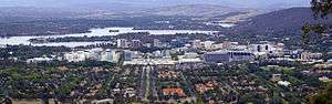
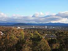
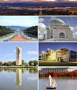 Canberra, from top left to bottom right–the city viewed from Mount Ainslie, the Land Axis featuring Old Parliament House and New Parliament House, the Australian War Memorial, the National Carillon, the National Gallery of Australia and the National Library of Australia on Lake Burley Griffin | |||||||||
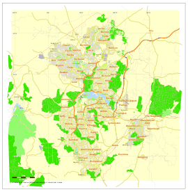 City map plan of Canberra | |||||||||
 Canberra | |||||||||
| Coordinates | 35°17′35″S 149°07′37″E | ||||||||
| Population | 426,704 (2019)[1] (8th) | ||||||||
| • Density | 503.932/km2 (1,305.18/sq mi) | ||||||||
| Established | 12 March 1913 | ||||||||
| Elevation | 578 m (1,896 ft)[2] | ||||||||
| Area | 814.2 km2 (314.4 sq mi)[3] | ||||||||
| Time zone | AEST (UTC+10:00) | ||||||||
| • Summer (DST) | AEDT (UTC+11:00) | ||||||||
| Location | |||||||||
| Territory electorate(s) |
| ||||||||
| Federal Division(s) |
| ||||||||
| |||||||||
On 1 January 1901, federation of the colonies of Australia was achieved. Section 125 of the new Australian Constitution provided that land, situated in New South Wales and at least 100 miles (160 km) from Sydney, would be ceded to the new federal government. Following discussion and exploration of various areas within New South Wales, the Seat of Government Act 1908 was passed in 1908 which specified a capital in the Yass-Canberra region. The land was transferred to the Commonwealth by New South Wales in 1911, creating the Australian Capital Territory, two years prior to the capital city being founded and formally named as Canberra in 1913.
It is unusual among Australian cities, being an entirely planned city outside of any state, similar to Washington, D.C. in the United States or Brasília in Brazil. Following an international contest for the city's design, a blueprint by American architects Walter Burley Griffin and Marion Mahony Griffin was selected and construction commenced in 1913.[12] The Griffins' plan featured geometric motifs such as circles, hexagons and triangles, and was centred on axes aligned with significant topographical landmarks in the Australian Capital Territory. The city's design was influenced by the garden city movement and incorporates significant areas of natural vegetation.
As the seat of the government of Australia, Canberra is home to many important institutions of the federal government, national monuments and museums. This includes Parliament House, the official residence of the monarch's representative the Governor-General, the High Court and numerous government departments and agencies. It is also the location of many social and cultural institutions of national significance such as the Australian War Memorial, the Australian National University, the Royal Australian Mint, the Australian Institute of Sport, the National Gallery, the National Museum and the National Library. The city is also home to many important institutions of the Australian Defence Force including the Royal Military College Duntroon and the Australian Defence Force Academy. It also hosts the majority of foreign embassies in Australia as well as regional headquarters of many international organisations, not-for-profit groups, lobbying groups and professional associations.
Canberra does not have a local council or city government like other Australian cities. The Australian Capital Territory Legislative Assembly performs the roles of both a city council for the city and a territory government for the rest of the Australian Capital Territory.[13] The vast majority of the population of the Territory reside in Canberra though and the city is therefore the primary focus of the ACT Government. However, the federal government maintains authority over the Territory and may overturn local laws. It still maintains control over the area known as the Parliamentary Triangle through the National Capital Authority.
As at June 2019 the population of Canberra was 426,704,[1] having grown by 1.5% over the preceding 12 months.[1] As the city has a high proportion of public servants, the Commonwealth Government contributes the largest percentage of gross territory product and is the largest single employer in Canberra, although not the majority employer. Compared to the national averages, the unemployment rate is lower and the average income higher; tertiary education levels are higher, while the population is younger.
Etymology
The word "Canberra" is popularly claimed to derive from the word Kambera or Canberry, which is claimed to mean "meeting place" in Ngunnawal, one of the Indigenous languages spoken in the district by Aboriginal Australians before European settlers arrived, although there is no clear evidence to support this.[14] An alternative definition has been claimed by numerous local commentators over the years, including the Ngunnawal elder Don Bell, whereby Canberra or Nganbra means "woman's breasts" and is the indigenous name for the two mountains, Black Mountain and Mount Ainslie, which lie almost opposite each other.[15] In the 1860s, the name was reported by Queanbeyan newspaper owner John Gale to be an interpretation of the name nganbra or nganbira, meaning "hollow between a woman's breasts", and referring to the Sullivans Creek floodplain between Mount Ainslie and Black Mountain.[16] An 1830s map of the region by Major Mitchell indeed does mark the Sullivan's Creek floodplain between these two mountains as "Nganbra". "Nganbra" or "Nganbira" could readily have been anglicised to the name "Canberry", as the locality soon become known to European settlers.
R. H. Cambage in his 1919 book Notes on the Native Flora of New South Wales, Part X, the Federal Capital Territory noted that Joshua John Moore, the first settler in the region, named the area Canberry in 1823 stating that "there seems no doubt that the original was a native name, but its meaning is unknown."'[17] Survey plans of the district dated 1837 refer to the area as the Canberry Plain. In 1920, some of the older residents of the district claimed that the name was derived from the Australian Cranberry which grew abundantly in the area, noting that the local name for the plant was canberry. Although popularly pronounced /ˈkænbərə/ or /kænˈbɛrə/, the original pronunciation at its official naming in 1913 was /ˈkænbrə/.[15]
History
The first inhabitants
Before white settlement, the area in which Canberra would eventually be constructed was seasonally inhabited by Indigenous Australians. Anthropologist Norman Tindale suggested the principal group occupying the region were the Ngunnawal people, while the Ngarigo lived immediately to the south of the ACT, the Wandandian to the east, the Walgulu also to the south, Gandangara people to the north and Wiradjuri to the north-west. Archaeological evidence of settlement in the region includes inhabited rock shelters, rock paintings and engravings, burial places, camps and quarry sites as well as stone tools and arrangements.[18] Artefacts suggests early human activity occurred at some point in the area 21,000 years previously.[19]
European exploration
European exploration and settlement started in the Canberra area as early as the 1820s.[21][22][23] There were four expeditions between 1820 and 1824.[22][23] White settlement of the area probably dates from 1823, when a homestead was built on what is now the Acton Peninsula by stockmen employed by Joshua John Moore.[24] He formally applied to purchase the site on 16 December 1826 and named the property "Canberry". On 30 April 1827, Moore was told by letter that he could retain possession of 1,000 acres (405 ha) at Canberry.[25]
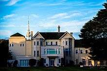
The European population in the Canberra area continued to grow slowly throughout the 19th century.[26] Among them was the Campbell family of "Duntroon";[27] their imposing stone house is now the officers' mess of the Royal Military College, Duntroon.[28] The Campbells sponsored settlement by other farmer families to work their land, such as the Southwells of "Weetangera".[29] Other notable early settlers included the inter-related Murray and Gibbes families, who owned the Yarralumla estate —now the site of the official residence of the Governor-General of Australia — from the 1830s through to 1881.[30] Associated with the Yarralumla Estate and Government House is the adjoining Yarralumla Woolshed
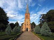
The oldest surviving public building in the inner-city is the Anglican Church of St John the Baptist, in the suburb of Reid,[31] which was consecrated in 1845.[32][33] St John's churchyard contains the earliest graves in the district.[34] It has been described as a "sanctuary in the city",[35][36] remaining a small English village-style church even as the capital grew around it. As the European presence increased, the indigenous population dwindled largely due to introduced diseases such as smallpox and measles.[37]
Creation of the nation's capital
The district's change from a rural area in New South Wales to the national capital started during debates over federation in the late 19th century.[38][39] Following a long dispute over whether Sydney or Melbourne should be the national capital,[40] a compromise was reached: the new capital would be built in New South Wales, so long as it was at least 100 miles (160 km) from Sydney,[38] with Melbourne to be the temporary seat of government while the new capital was built.[41] A survey was conducted across several sites in New South Wales with Bombala, southern Monaro, Orange, Yass, Albury, Tamworth, Armidale, Tumut and Dalgety all discussed.[42] Dalgety was chosen by the federal parliament and it passed the Seat of Government Act 1904 confirming Dalgety as the site of the nation's capital. However, the New South Wales government refused to cede the required territory as they did not accept the site.[42] In 1906, the New South Wales Government finally agreed to cede sufficient land provided that it was in the Yass-Canberra region as this site was closer to Sydney.[43] Newspaper proprietor John Gale circulated a pamphlet titled 'Dalgety or Canberra: Which?' advocating Canberra to every member of the Commonwealth's seven state and federal parliaments. By many accounts, it was decisive in the selection of Canberra as the site in 1908 as was a result of survey work done by the government surveyor Charles Scrivener.[44] The NSW government ceded the district to the federal government in 1911 and the Federal Capital Territory was established.[38]
An international design competition was launched by the Department of Home Affairs on 30 April 1911, closing on 31 January 1912. The competition was boycotted by the Royal Institute of British Architects, the Institution of Civil Engineers and their affiliated bodies throughout the British Empire because the Minister for Home Affairs King O'Malley insisted that the final decision was for him to make rather than an expert in city planning.[45] A total of 137 valid entries were received. O'Malley appointed a three-member board to advise him but they could not reach unanimity. On 24 May 1911,[46] O'Malley came down on the side of the majority of the board with the design by Walter Burley Griffin and Marion Mahony Griffin of Chicago, Illinois, United States, being declared the winner.[47][48] Second was Eliel Saarinen of Finland and third was Alfred Agache of Brazil but resident in Paris, France.[45] O'Malley then appointed a six-member board to advise him on the implementation of the winning design. On 25 November 1912, the board advised that it could not support Griffin's plan in its entirety and suggested an alternative plan of its own devising. This plan incorporated the best features of the three place-getting designs as well as of a fourth design by H. Caswell, R.C.G. Coulter and W. Scott-Griffiths of Sydney, the rights to which it had purchased. It was this composite plan that was endorsed by Parliament and given formal approval by O'Malley on 10 January 1913.[45] In 1913, Griffin was appointed Federal Capital Director of Design and Construction and construction began.[49] On 23 February, King O'Malley drove the first peg in the construction of the future capital city.
In 1912, the government invited suggestions from the public as to the name of the future city. Almost 750 names were suggested. At midday on 12 March 1913,[50][51] Lady Denman, the wife of Governor-General Lord Denman, announced that the city would be named "Canberra" at a ceremony at Kurrajong Hill,[52][53][54] which has since become Capital Hill and the site of the present Parliament House.[55] Canberra Day is a public holiday observed in the ACT on the second Monday in March to celebrate the founding of Canberra.[37] After the ceremony, bureaucratic disputes hindered Griffin's work;[56] a Royal Commission in 1916 ruled his authority had been usurped by certain officials and his original plan was reinstated.[57] Griffin's relationship with the Australian authorities was strained and a lack of funding meant that by the time he was fired in 1920, little work had been done.[58][59] By this time, Griffin had revised his plan, overseen the earthworks of major avenues and established the Glenloch Cork Plantation.[60][61]
Development throughout 20th century
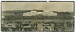
The Commonwealth parliament moved to Canberra on 9 May 1927 with the opening of the Provisional Parliament House.[62][63] The Prime Minister Stanley Bruce had officially taken up residence in The Lodge a few days earlier.[64][65] Planned development of the city slowed significantly during the depression of the 1930s and during World War II.[66] Some projects planned for that time, including Roman Catholic and Anglican cathedrals, were never completed.[67]
From 1920 to 1957, three bodies — successively the Federal Capital Advisory Committee,[68] the Federal Capital Commission,[69] and the National Capital Planning and Development Committee — continued to plan the further expansion of Canberra in the absence of Griffin. However, they were only advisory and development decisions were made without consulting them, which increased inefficiency.[60][70]
The largest event in Canberra up to World War II was the 24th Meeting of ANZAAS in January 1939. The Canberra Times described it as "a signal event ... in the history of this, the world's youngest capital city". The city's accommodation was not nearly sufficient to house the 1,250 delegates and a tent city had to be set up on the banks of the Molonglo River. One of the prominent speakers was H. G. Wells, who was a guest of the Governor-General Lord Gowrie for a week. This event coincided with a heatwave across south-eastern Australia during which the temperature in Canberra reached 108.5 degrees Fahrenheit (42.5 Celsius) on 11 January. On Friday, 13 January, the Black Friday bushfires caused 71 deaths in Victoria and Wells accompanied the Governor-General on his tour of areas threatened by fires.[71]
Immediately after the end of the war, Canberra was criticised for resembling a village and its disorganised collection of buildings was deemed ugly.[72][73][74] Canberra was often derisively described as "several suburbs in search of a city".[75] Prime Minister Sir Robert Menzies regarded the state of the national capital as an embarrassment.[76] Over time his attitude changed from one of contempt to that of championing its development. He fired two ministers charged with the development of the city for poor performance. Menzies remained in office for over a decade and in that time the development of the capital sped up rapidly.[77][78] The population grew by more than 50 per cent in every five-year period from 1955 to 1975.[78] Several Government departments, together with public servants, were moved to Canberra from Melbourne following the war.[79] Government housing projects were undertaken to accommodate the city's growing population.[80]
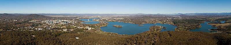
The National Capital Development Commission (NCDC) formed in 1957 with executive powers and ended four decades of disputes over the shape and design of Lake Burley Griffin — the centrepiece of Griffin's design — and construction was completed in 1964 after four years of work.[81] The completion of the lake finally laid the platform for the development of Griffin's Parliamentary Triangle.[82] Since the initial construction of the lake, various buildings of national importance have been constructed on its shores.[83]
The newly built Australian National University was expanded and sculptures as well as monuments were built.[83][84] A new National Library was constructed within the Parliamentary Triangle, followed by the High Court and the National Gallery.[31][85] Suburbs in Canberra Central (often referred to as North Canberra and South Canberra) were further developed in the 1950s and urban development in the districts of Woden Valley and Belconnen commenced in the mid and late 1960s respectively.[86][87] Many of the new suburbs were named after Australian politicians such as Barton, Deakin, Reid, Braddon, Curtin, Chifley and Parkes.[88]
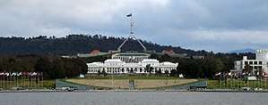
On 9 May 1988, a larger and permanent Parliament House was opened on Capital Hill as part of Australia's bicentenary celebrations.[89][85] The Commonwealth Parliament moved there from the Provisional Parliament House, now known as Old Parliament House.[89]
Self-government
In December 1988, the Australian Capital Territory was granted full self-government by the Commonwealth Parliament. Following the first election on 4 March 1989,[90] a 17-member Legislative Assembly sat at temporary offices at 1 Constitution Avenue, Civic, on 11 May 1989.[91][92] Permanent premises were opened on London Circuit in 1994.[92] The Australian Labor Party formed the ACT's first government, led by the Chief Minister Rosemary Follett, who made history as Australia's first female head of government.[93][94]
Parts of Canberra were engulfed by bushfires on 18 January 2003 that killed four people, injured 435 and destroyed more than 500 homes as well as the major research telescopes of Australian National University's Mount Stromlo Observatory.[95]
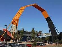
Throughout 2013, several events celebrated the 100th anniversary of the naming of Canberra.[96] On 11 March 2014, the last day of the centennial year, the Canberra Centenary Column was unveiled in City Hill. Other works included The Skywhale, a hot air balloon designed by the sculptor Patricia Piccinini,[97] and StellrScope by visual media artist Eleanor Gates-Stuart.[98]
Geography
Canberra covers an area of 814.2 square kilometres (314.4 sq mi)[3] and is located near the Brindabella Ranges, approximately 150 kilometres (93 mi) inland from Australia's east coast. It has an elevation of approximately 580 metres (1,900 ft) AHD;[99] the highest point is Mount Majura at 888 m (2,913 ft).[100][101] Other low mountains include Mount Taylor 855 m (2,805 ft),[102] Mount Ainslie 843 m (2,766 ft),[103] Mount Mugga Mugga 812 m (2,664 ft)[104] and Black Mountain 812 m (2,664 ft).[105][106]
The native forest in the Canberra region was almost wholly eucalypt species and provided a resource for fuel and domestic purposes. By the early 1960s, logging had depleted the eucalypt, and concern about water quality led to the forests being closed. Interest in forestry began in 1915 with trials of a number of species including Pinus radiata on the slopes of Mount Stromlo. Since then, plantations have been expanded, with the benefit of reducing erosion in the Cotter catchment, and the forests are also popular recreation areas.[107]
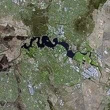
The urban environs of the city of Canberra straddle the Ginninderra plain, Molonglo plain, the Limestone plain, and the Tuggeranong plain (Isabella's Plain).[108] The Molonglo River which flows across the Molonglo plain has been dammed to form the national capital's iconic feature Lake Burley Griffin.[109] The Molonglo then flows into the Murrumbidgee north-west of Canberra, which in turn flows north-west toward the New South Wales town of Yass. The Queanbeyan River joins the Molonglo River at Oaks Estate just within the ACT.[108]
A number of creeks, including Jerrabomberra and Yarralumla Creeks, flow into the Molonglo and Murrumbidgee.[108] Two of these creeks, the Ginninderra and Tuggeranong, have similarly been dammed to form Lakes Ginninderra and Tuggeranong.[110][111][112] Until recently the Molonglo River had a history of sometimes calamitous floods; the area was a flood plain prior to the filling of Lake Burley Griffin.[113][114]
Climate
Under the Köppen-Geiger classification, Canberra has an oceanic climate (Cfb).[115] In January, the warmest month, the average high is approximately 28 °C (82 °F); however, in July, the coldest month, the average high drops to approximately 11 °C (52 °F).
Frost is common in the winter months. Snow is rare in the CBD (central business district), but the surrounding areas get annual snowfall through winter and often the snow-capped mountains can be seen from the CBD. The last significant snowfall in the city centre was in 1968.[99]
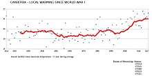
The highest recorded maximum temperature was 44.0 °C (111.2 °F) on 4 January 2020.[116] Winter 2011 was Canberra's warmest winter on record, approximately 2 °C (4 °F) above the average temperature.[117] Canberra is being impacted by Global Warming indicated by a long-running tendency for temperatures to increase.[118]
The lowest recorded minimum temperature was −10.0 °C (14.0 °F) on the morning of 11 July 1971.[99] Light snow falls only once or twice per year, and it is usually not widespread and quickly dissipates.[99]
Canberra is protected from the west by the Brindabellas which create a slight rain shadow in Canberra's valleys.[99] Canberra gets 100.4 clear days annually.[119] Annual rainfall is the third lowest of the capital cities (after Adelaide and Hobart)[120] and is spread fairly evenly over the seasons, with late spring bringing the highest rainfall.[121] Thunderstorms occur mostly between October and April,[99] owing to the effect of summer and the mountains. The area is not very windy and the breeze is at its strongest from August to November. Canberra is less humid than the nearby coastal areas.[99]
Smoke haze became synonymous with the 2019/2020 Australian summer. On 1 January 2020 Canberra had the worst air quality of any major city in the world, with an AQI of 7700 (USAQI 949).[122]
| Climate data for Canberra Airport, ACT (1981-2010 normals, extremes 1939-present) | |||||||||||||
|---|---|---|---|---|---|---|---|---|---|---|---|---|---|
| Month | Jan | Feb | Mar | Apr | May | Jun | Jul | Aug | Sep | Oct | Nov | Dec | Year |
| Record high °C (°F) | 44.0 (111.2) |
42.7 (108.9) |
37.5 (99.5) |
32.6 (90.7) |
24.5 (76.1) |
20.1 (68.2) |
19.7 (67.5) |
24.0 (75.2) |
30.2 (86.4) |
32.7 (90.9) |
39.9 (103.8) |
41.6 (106.9) |
44.0 (111.2) |
| Average high °C (°F) | 28.7 (83.7) |
27.7 (81.9) |
24.8 (76.6) |
20.5 (68.9) |
16.3 (61.3) |
12.5 (54.5) |
11.8 (53.2) |
13.5 (56.3) |
16.6 (61.9) |
19.9 (67.8) |
23.3 (73.9) |
26.3 (79.3) |
20.2 (68.4) |
| Daily mean °C (°F) | 21.2 (70.2) |
20.7 (69.3) |
17.9 (64.2) |
13.8 (56.8) |
10.0 (50.0) |
6.9 (44.4) |
6.0 (42.8) |
7.4 (45.3) |
10.2 (50.4) |
13.2 (55.8) |
16.4 (61.5) |
19.1 (66.4) |
13.6 (56.5) |
| Average low °C (°F) | 13.7 (56.7) |
13.6 (56.5) |
10.9 (51.6) |
7.1 (44.8) |
3.7 (38.7) |
1.3 (34.3) |
0.2 (32.4) |
1.3 (34.3) |
3.8 (38.8) |
6.4 (43.5) |
9.5 (49.1) |
11.9 (53.4) |
7.0 (44.6) |
| Record low °C (°F) | 1.6 (34.9) |
2.8 (37.0) |
−1.1 (30.0) |
−3.7 (25.3) |
−7.5 (18.5) |
−8.5 (16.7) |
−10.0 (14.0) |
−8.5 (16.7) |
−6.8 (19.8) |
−3.4 (25.9) |
−1.8 (28.8) |
0.3 (32.5) |
−10.0 (14.0) |
| Average precipitation mm (inches) | 58.5 (2.30) |
56.4 (2.22) |
50.7 (2.00) |
46.0 (1.81) |
44.4 (1.75) |
40.4 (1.59) |
41.4 (1.63) |
46.2 (1.82) |
52.0 (2.05) |
62.4 (2.46) |
64.4 (2.54) |
53.2 (2.09) |
615.2 (24.22) |
| Average precipitation days | 7.3 | 6.7 | 6.9 | 7.3 | 8.4 | 9.8 | 10.5 | 11.1 | 10.2 | 10.4 | 9.8 | 7.7 | 106.1 |
| Mean monthly sunshine hours | 294.5 | 254.3 | 251.1 | 219.0 | 186.0 | 156.0 | 179.8 | 217.0 | 231.0 | 266.6 | 267.0 | 291.4 | 2,813.7 |
| Source #1: Climate averages for Canberra Airport Comparison (1939–2010); averages given are for 1981–2010[119][123] | |||||||||||||
| Source #2: Climate averages for Canberra Airport for more recent extremes[124] | |||||||||||||
Urban structure
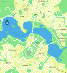
Canberra is a planned city and the inner-city area was originally designed by Walter Burley Griffin, a major 20th-century American architect.[125] Within the central area of the city near Lake Burley Griffin, major roads follow a wheel-and-spoke pattern rather than a grid.[126] Griffin's proposal had an abundance of geometric patterns, including concentric hexagonal and octagonal streets emanating from several radii.[126] However, the outer areas of the city, built later, are not laid out geometrically.[127]
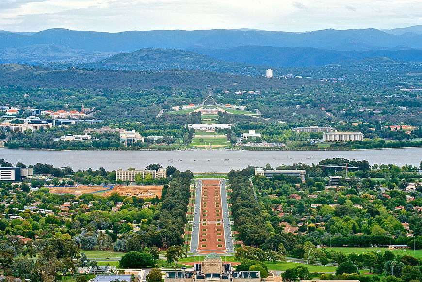
Lake Burley Griffin was deliberately designed so that the orientation of the components was related to various topographical landmarks in Canberra.[128][129] The lakes stretch from east to west and divided the city in two; a land axis perpendicular to the central basin stretches from Capital Hill—the eventual location of the new Parliament House on a mound on the southern side—north northeast across the central basin to the northern banks along Anzac Parade to the Australian War Memorial.[73] This was designed so that looking from Capital Hill, the War Memorial stood directly at the foot of Mount Ainslie. At the southwestern end of the land axis was Bimberi Peak,[129] the highest mountain in the ACT, approximately 52 km (32 mi) south west of Canberra.[106]
The straight edge of the circular segment that formed the central basin of Lake Burley Griffin was perpendicular to the land axis and designated the water axis, and it extended northwest towards Black Mountain.[129] A line parallel to the water axis, on the northern side of the city, was designated the municipal axis.[130] The municipal axis became the location of Constitution Avenue, which links City Hill in Civic Centre and both Market Centre and the Defence precinct on Russell Hill. Commonwealth Avenue and Kings Avenue were to run from the southern side from Capital Hill to City Hill and Market Centre on the north respectively, and they formed the western and eastern edges of the central basin. The area enclosed by the three avenues was known as the Parliamentary Triangle, and formed the centrepiece of Griffin's work.[129][130]
The Griffins assigned spiritual values to Mount Ainslie, Black Mountain, and Red Hill and originally planned to cover each of these in flowers. That way each hill would be covered with a single, primary colour which represented its spiritual value.[131] This part of their plan never came to fruition, as World War I slowed construction and planning disputes led to Griffin's dismissal by Prime Minister Billy Hughes after the war ended.[58][59][132]
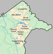
The urban areas of Canberra are organised into a hierarchy of districts, town centres, group centres, local suburbs as well as other industrial areas and villages. There are seven residential districts, each of which is divided into smaller suburbs, and most of which have a town centre which is the focus of commercial and social activities.[133] The districts were settled in the following chronological order:
- Canberra Central, mostly settled in the 1920s and 1930s, with expansion up to the 1960s,[134] 25 suburbs
- Woden Valley, first settled in 1964,[87] 12 suburbs
- Belconnen, first settled in 1966,[87] 27 suburbs (2 not yet developed)
- Weston Creek, settled in 1969, 8 suburbs[135]
- Tuggeranong, settled in 1974,[136] 18 suburbs
- Gungahlin, settled in the early 1990s, 18 suburbs (3 not yet developed)
- Molonglo Valley, development began in 2010, 13 suburbs planned.
The Canberra Central district is substantially based on Walter Burley Griffin's designs.[129][130][137] In 1967 the then National Capital Development Commission adopted the "Y Plan" which laid out future urban development in Canberra around a series of central shopping and commercial area known as the 'town centres' linked by freeways, the layout of which roughly resembled the shape of the letter Y,[138] with Tuggeranong at the base of the Y and Belconnen and Gungahlin located at the ends of the arms of the Y.[138]
Development in Canberra has been closely regulated by government,[139][140] both through planning processes and the use of crown lease terms that have tightly limited the use of parcels of land. Land in the ACT is held on 99-year crown leases from the national government, although most leases are now administered by the Territory government.[141] There have been persistent calls for constraints on development to be liberalised.[140]
Many of Canberra's suburbs are named after former Prime Ministers, famous Australians, early settlers, or use Aboriginal words for their title.[142] Street names typically follow a particular theme; for example, the streets of Duffy are named after Australian dams and reservoirs, the streets of Dunlop are named after Australian inventions, inventors and artists and the streets of Page are named after biologists and naturalists.[142] Most diplomatic missions are located in the suburbs of Yarralumla, Deakin and O'Malley.[143] There are three light industrial areas: the suburbs of Fyshwick, Mitchell and Hume.[144]
Points of Interest Looking South from Mount Ainslie
| ||||||||||||||||||||||||||||||||||||||||||||||
Sustainability and the environment
The average Canberran was responsible for 13.7 tonnes of greenhouse gases in 2005.[146] In 2012, the ACT Government legislated greenhouse gas targets to reduce its emissions by 40 per cent from 1990 levels by 2020, 80 per cent by 2050, with no net emissions by 2060.[147] The government announced in 2013 a target for 90% of electricity consumed in the ACT to be supplied from renewable sources by 2020,[148] and in 2016 set an ambitious target of 100% by 2020.[149][150]
In 1996 Canberra became the first city in the world to set a vision of no waste, proposing an ambitious target of 2010 for completion.[151] The strategy aimed to achieve a waste-free society by 2010, through the combined efforts of industry, government and community.[152] By early 2010, it was apparent that though it had reduced waste going to landfill, the ACT initiative's original 2010 target for absolutely zero landfill waste would be delayed or revised to meet the reality.[153][154]
Plastic bags made of polyethylene polymer with a thickness of less than 35 µm were banned from retail distribution in the ACT from November 2011.[155][156][157] The ban was introduced by the ACT Government in an effort to make Canberra more sustainable.[156]
Of all waste produced in the ACT, 75 per cent is recycled.[158] Average household food waste in the ACT remains above the Australian average, costing an average $641 per household per annum.[159]
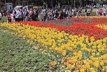
Canberra's annual Floriade festival features a large display of flowers every Spring in Commonwealth Park. The organisers of the event have a strong environmental standpoint, promoting and using green energy, "green catering", sustainable paper, the conservation and saving of water.[145] The event is also smoke-free.[145]
Government and politics

and the statue Ethos (Tom Bass, 1961)
Territory government
There is no local council or city government for the city of Canberra. The Australian Capital Territory Legislative Assembly performs the roles of both a city council for the city and a territory government for the rest of the Australian Capital Territory.[13] However, the vast majority of the population of the Territory reside in Canberra and the city is therefore the primary focus of the ACT Government.
The assembly consists of 25 members elected from five districts using proportional representation. The five districts are Brindabella, Ginninderra, Kurrajong, Murrumbidgee and Yerrabi, which each elect five members.[160] The Chief Minister is elected by the Members of the Legislative Assembly (MLA) and selects colleagues to serve as ministers alongside him or her in the Executive, known informally as the cabinet.[13] As of April 2019, the Chief Minister was Andrew Barr from the Australian Labor Party.
Whereas the ACT has federally been dominated by Labor,[161][162] the Liberals have been able to gain some footing in the ACT Legislative Assembly and were in government during a period of six and half years from 1995 and 2001. Labor took back control of the Assembly in 2001.[93] At the 2004 election, Chief Minister Jon Stanhope and the Labor Party won 9 of the 17 seats allowing them to form the ACT's first majority government.[93] Since 2008, the ACT has been governed by a coalition of Labor and the Greens.[93][163][164]
The Australian federal government retains some influence over the ACT government. In the administrative sphere, most frequently this is through the actions of the National Capital Authority which is responsible for planning and development in areas of Canberra which are considered to be of national importance or which are central to Griffin's plan for the city,[165] such as the Parliamentary Triangle, Lake Burley Griffin, major approach and processional roads, areas where the Commonwealth retains ownership of the land or undeveloped hills and ridge-lines (which form part of the Canberra Nature Park).[165][166][167] The national government also retains a level of control over the Territory Assembly through the provisions of the Australian Capital Territory (Self-Government) Act 1988.[168] This federal act defines the legislative power of the ACT assembly.[169]
Federal representation
The ACT was given its first federal parliamentary representation in 1949 when it gained a seat in the House of Representatives, the Division of Australian Capital Territory.[170][171] However, the ACT member could only vote on matters directly affecting the territory.[171] In 1974, the ACT was allocated two Senate seats and the House of Representatives seat was divided into two.[170] A third was created in 1996, but was abolished in 1998 because of changes to the regional demographic distribution.[161] At the 2019 election, the third seat has been reintroduced as the Division of Bean.
Both House of Representatives seats have mostly been held by Labor and usually by comfortable margins.[161][162] The Labor Party has polled at least seven percentage points more than the Liberal Party at every federal election since 1990 and their average lead since then has been 15 percentage points.[93] The ALP and the Liberal Party have always held one Senate seat each.[172]
Judiciary and policing
The Australian Federal Police (AFP) provides all of the constabulary services in the territory in a manner similar to state police forces, under a contractual agreement with the ACT Government.[173] The AFP does so through its community policing arm ACT Policing.[174]
People who have been charged with offences are tried either in the ACT Magistrates Court or, for more severe offences, the ACT Supreme Court.[175] Prior to its closure in 2009, prisoners were held in remand at the Belconnen Remand Centre in the ACT but usually imprisoned in New South Wales.[176] The Alexander Maconochie Centre was officially opened on 11 September 2008 by then Chief Minister Jon Stanhope. The total cost for construction was $130 million.[177] The ACT Civil and Administrative Tribunal deal with minor civil law actions and other various legal matters.[178][179]
Canberra has the lowest rate of crime of any capital city in Australia as of February 2019.[180] As of 2016 the most common crimes in the ACT were property related crimes, unlawful entry with intent and motor vehicle theft. They affected 2,304 and 966 people (580 and 243 per 100,000 persons respectively). Homicide and related offences—murder, attempted murder and manslaughter, but excluding driving causing death and conspiracy to murder—affect 1.0 per 100,000 persons, which is below the national average of 1.9 per 100,000. Rates of sexual assault (64.4 per 100,000 persons) are also below the national average (98.5 per 100,000).[181][182][183] However the 2017 crime statistics showed a rise in some types of personal crime, notably burglaries, thefts and assaults.
Economy
In February 2020, the unemployment rate in Canberra was 2.9% which was lower than the national unemployment rate of 5.1%.[184] As a result of low unemployment and substantial levels of public sector and commercial employment, Canberra has the highest average level of disposable income of any Australian capital city.[185] The gross average weekly wage in Canberra is $1827 compared with the national average of $1658 (November 2019).[186]
The median house price in Canberra as of February 2020 was $745,000, lower than only Sydney among capital cities of more than 100,000 people, having surpassed Melbourne and Perth since 2005.[186][187][188] The median weekly rent paid by Canberra residents is higher than rents in all other states and territories.[189] As of January 2014 the median unit rent in Canberra was $410 per week and median housing rent was $460, making the city the third most expensive in the country.[190] Factors contributing to this higher weekly rental market include; higher average weekly incomes, restricted land supply,[191] and inflationary clauses in the ACT Residential Tenancies Act.[192]
The city's main industry is public administration and safety, which accounted for 27.1% of Gross Territory Product in 2018-19 and employed 32.49% of Canberra's workforce.[193][194] The headquarters of many Australian Public Service agencies are located in Canberra, and Canberra is also host to several Australian Defence Force establishments, most notably the Australian Defence Force headquarters and HMAS Harman, which is a naval communications centre that is being converted into a tri-service, multi-user depot.[195] Other major sectors by employment include Health Care (10.54%), Professional Services (9.77%), Education and Training (9.64%), Retail (7.27%), Accommodation & Food (6.39%) and Construction (5.80%).[194]
The former RAAF Fairbairn, adjacent to the Canberra Airport was sold to the operators of the airport,[196] but the base continues to be used for RAAF VIP flights.[197][198] A growing number of software vendors have based themselves in Canberra, to capitalise on the concentration of government customers; these include Tower Software and RuleBurst.[199][200] A consortium of private and government investors is making plans for a billion-dollar data hub, with the aim of making Canberra a leading centre of such activity in the Asia-Pacific region.[201] A Canberra Cyber Security Innovation Node was established in 2019 to grow the ACT's cyber security sector and related space, defence and education industries.[202]
Demographics
At the 2016 census, the population of Canberra was 395,790,[203] up from 355,596 at the 2011 census[204] and 322,036 at the 2006 census.[205]
Canberrans are relatively young, highly mobile and well educated. The median age is 35 years and only 12.7% of the population is aged over 65 years.[203] Between 1996 and 2001, 61.9% of the population either moved to or from Canberra, which was the second highest mobility rate of any Australian capital city.[206] As at May 2017, 43% of ACT residents (25–64) had a level of educational attainment equal to at least a bachelor's degree, significantly higher that the national average of 31%.[207]
According to statistics collected by the National Australia Bank and reported in The Canberra Times, Canberrans on average give significantly more money to charity than Australians in other states and territories, for both dollar giving and as a proportion of income.[208]
Ancestry and immigration
.jpeg)
| Country of Birth (2016)[209] | |
|---|---|
| Birthplace[N 1] | Population |
| Australia | 269,682 |
| England | 12,739 |
| Mainland China | 11,334 |
| India | 10,405 |
| New Zealand | 4,722 |
| Philippines | 3,789 |
| Vietnam | 3,340 |
| United States | 2,775 |
| Sri Lanka | 2,774 |
| Malaysia | 2,431 |
| South Korea | 2,283 |
At the 2016 census, the most commonly nominated ancestries were:[N 2][209]
- English (35%)
- Australian (34%)[N 3]
- Irish (14%)
- Scottish (11%)
- Chinese (6%)
- German (4.7%)
- Indian (3.9%)
- Italian (3.5%)
- Dutch (1.7%)
- Indigenous (1.6%)[N 4]
- Filipino (1.3%)
- Vietnamese (1.3%)
- Greek (1.3%)
- Croatian (1.2%)
- Polish (1.1%)
The 2016 census showed that 32% of Canberra's inhabitants were born overseas.[209] Of inhabitants born outside of Australia, the most prevalent countries of birth were England, China, India, New Zealand and the Philippines.[211]
1.6% of the population, or 6,476 people, identified as Indigenous Australians (Aboriginal Australians and Torres Strait Islanders) in 2016.[N 5][209]
Language
At the 2016 census, 72.7% of people spoke only English at home. The other languages most commonly spoken at home were Mandarin (3.1%), Vietnamese (1.1%), Cantonese (1%), Hindi (0.9%) and Spanish (0.8%).[209]
Religion
On census night in 2016, approximately 50.0% of ACT residents described themselves as Christian (excluding not stated responses), the most common denominations being Catholic and Anglican; 36.2% described themselves as having no religion.[203]
Culture
Education
The two main tertiary institutions are the Australian National University (ANU) in Acton and the University of Canberra (UC) in Bruce, with over 10,500 and 8,000 full-time-equivalent students respectively.[212][213] Established in 1946,[214] the ANU has always had a strong research focus and is ranked among the leading universities in the world and the best in Australia by The Times Higher Education Supplement and the Shanghai Jiao Tong World University Rankings.[213][215] There are two religious university campuses in Canberra: Signadou in the northern suburb of Watson is a campus of the Australian Catholic University;[216] St Mark's Theological College in Barton is part of the secular Charles Sturt University.[217]
The Australian Defence College has two campuses: the Australian Command and Staff College (ACSC) plus the Centre for Defence and Strategic Studies (CDSS) at Weston, and the Australian Defence Force Academy (ADFA) beside the Royal Military College, Duntroon located in the inner-northern suburb of Campbell.[218][219] ADFA teaches military undergraduates and postgraduates and includes UNSW@ADFA, a campus of the University of New South Wales;[220][221] Duntroon provides Australian Army officer training.[222] Tertiary level vocational education is also available through the multi-campus Canberra Institute of Technology.[223] The ACT Government announced on 5 March 2020 that the CIT campus and an adjoining carpark in Reid would be leased to the University of New South Wales for a peppercorn lease, for it to develop as a university campus. UNSW is expected to invest A$1B in the redevelopment, that will take some 15 years to complete. It will then have around 6,000 students and 2,000 staff. The CIT Reid campus activities are to be transitioned to the new Woden campus.[224]
In 2016 there were 132 schools in Canberra; 87 were operated by the government and 45 were private.[225] During 2006, the ACT Government announced closures of up to 39 schools, to take effect from the end of the school year, and after a series of consultations unveiled its Towards 2020: Renewing Our Schools policy.[226] As a result, some schools closed during the 2006–08 period, while others were merged; the creation of combined primary and secondary government schools will proceed over the next decade. The new policy has provoked significant opposition.[227][228][229] Most suburbs are planned to include a primary and a nearby preschool; these are usually located near open areas where recreational and sporting activities are easily available.[230] Canberra also has the highest percentage of non-government (private) school students in Australia, accounting for 40.6 per cent of ACT enrollments.[231]
Arts and entertainment
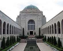
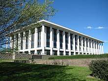
Canberra is home to many national monuments and institutions such as the Australian War Memorial, the National Gallery of Australia, the National Portrait Gallery, the National Library,[137] the National Archives,[232] the Australian Academy of Science,[233] the National Film and Sound Archive and the National Museum.[137] Many Commonwealth government buildings in Canberra are open to the public, including Parliament House, the High Court and the Royal Australian Mint.[234][235][236]
Lake Burley Griffin is the site of the Captain James Cook Memorial and the National Carillon.[137] Other sites of interest include the Telstra Tower, the Australian National Botanic Gardens, the National Zoo and Aquarium, the National Dinosaur Museum and Questacon – the National Science and Technology Centre.[137][237]
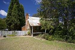
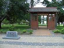
The Canberra Museum and Gallery in the city is a repository of local history and art, housing a permanent collection and visiting exhibitions.[239] Several historic homes are open to the public: Lanyon and Tuggeranong Homesteads in the Tuggeranong Valley,[240][241] Mugga-Mugga in Symonston,[242] and Blundells' Cottage in Parkes all display the lifestyle of the early European settlers.[20] Calthorpes' House in Red Hill is a well-preserved example of a 1920s house from Canberra's very early days.[243] Strathnairn Homestead is an historic building which also dates from the 1920s.
Canberra has many venues for live music and theatre: the Canberra Theatre and Playhouse which hosts many major concerts and productions;[244] and Llewellyn Hall (within the ANU School of Music), a world-class concert hall are two of the most notable.[245] The Street Theatre is a venue with less mainstream offerings.[245] The Albert Hall was the city's first performing arts venue, opened in 1928. It was the original performance venue for theatre groups such as the Canberra Repertory Society.[246]
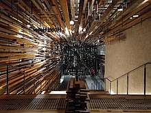
.jpeg)
Stonefest was a large annual festival, for some years one of the biggest festivals in Canberra.[247][248] It was downsized and rebranded as Stone Day in 2012.[249] There are numerous bars and nightclubs which also offer live entertainment, particularly concentrated in the areas of Dickson, Kingston and the city.[250] Most town centres have facilities for a community theatre and a cinema, and they all have a library.[251] Popular cultural events include the National Folk Festival, the Royal Canberra Show, the Summernats car festival, Enlighten festival, the National Multicultural Festival in February and the Celebrate Canberra festival held over 10 days in March in conjunction with Canberra Day.[252]
Canberra maintains sister-city relationships with both Nara, Japan and Beijing, China. Canberra has friendship-city relationships with both Dili, East Timor and Hangzhou, China.[253] City-to-city relationships encourage communities and special interest groups both locally and abroad to engage in a wide range of exchange activities. The Canberra Nara Candle Festival held annually in spring, is a community celebration of the Canberra Nara Sister City relationship.[254] The festival is held in Canberra Nara Park on the shores of Lake Burley Griffin.[255]
Media
As Australia's capital, Canberra is the most important centre for much of Australia's political reportage and thus all the major media, including the Australian Broadcasting Corporation, the commercial television networks, and the metropolitan newspapers maintain local bureaus. News organisations are represented in the "press gallery", a group of journalists who report on the national parliament. The National Press Club of Australia in Barton has regular television broadcasts of its lunches at which a prominent guest, typically a politician or other public figure, delivers a speech followed by a question-and-answer session.[256]
Canberra has a daily newspaper, The Canberra Times, which was established in 1926.[257][258] There are also several free weekly publications, including news magazines CityNews and Canberra Weekly as well as entertainment guide BMA Magazine. BMA Magazine first went to print in 1992; the inaugural edition featured coverage of the Nirvana Nevermind tour.[259]
There are a number of AM and FM stations broadcasting in Canberra (AM/FM Listing). The main commercial operators are the Capital Radio Network (2CA and 2CC), and Austereo/ARN (104.7 and Mix 106.3). There are also several community operated stations.
A DAB+ digital radio trial is also in operation, it simulcasts some of the AM/FM stations, and also provides several digital only stations (DAB+ Trial Listing).
Five free-to-air television stations service Canberra:
- ABC Canberra (ABC)
- SBS New South Wales (SBS)
- Win Television Southern NSW & ACT (WIN) – Network Ten affiliate
- Prime7 Southern NSW & ACT (CBN) – Seven Network affiliate
- Southern Cross Nine Southern NSW & ACT (CTC) – Nine Network affiliate
Each station broadcasts a primary channel and several multichannels. Of the three main commercial networks:
- WIN airs a half-hour local WIN News each weeknight at 6pm, produced from a newsroom in the city and broadcast from studios in Wollongong.
- Southern Cross Nine airs a regional edition of Nine News from Sydney each weeknight at 6pm, featuring opt-outs for Canberra and the ACT.
- Prime7 airs short local news and weather updates throughout the day, produced and broadcast from its Canberra studios.
Prior to 1989, Canberra was serviced by just the ABC, SBS and Capital Television (CTC), which later became Southern Cross Nine, with Prime Television (now Prime7) and WIN Television arriving as part of the Government's regional aggregation program in that year.[260]
Pay television services are available from Foxtel (via satellite) and telecommunications company TransACT (via cable).[261]
Sport
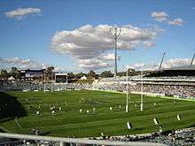
In addition to local sporting leagues, Canberra has a number of sporting teams that compete in national and international competitions. The best known teams are the Canberra Raiders and the Brumbies who play rugby league and rugby union respectively; both have been champions of their leagues.[262][263] Both teams play their home games at Canberra Stadium,[264] which is the city's largest stadium and was used to hold group matches in soccer for the 2000 Summer Olympics and in rugby union for the 2003 Rugby World Cup.[265][266] The city also has a successful basketball team, the Canberra Capitals, which has won seven out of the last eleven national women's basketball titles.[267] Canberra United FC represents the city in the W-League, the national women's association football league, and were champions in the 2011–12 season.[268] The Canberra Vikings represent the city in the National Rugby Championship and finished second in the 2015 season.
There are also teams that participate in national competitions in netball, field hockey, ice hockey, cricket and baseball. Manuka Oval is another large outdoor sporting facility where cricket and Australian Rules football are played.
Expansion AFL club Greater Western Sydney Giants commenced a partnership with Canberra in 2012 under which it will play three home games at Manuka Oval each season until at least 2021. Prior to this the Melbourne-based AFL team the Kangaroos played some home games at Manuka Oval until July 2006.[269] Following the move of the Kangaroos' alternative home ground to Carrara in Queensland, Melbourne and the Western Bulldogs played some home games at Manuka Oval from 2007 against the Sydney Swans.[270] Canberra is also home to the Barassi International Australian Football Youth Tournament.[271] The historic Prime Minister's XI cricket match is played at Manuka Oval annually.[272] Other significant annual sporting events include the Canberra Marathon[273] and the City of Canberra Half Ironman Triathlon.
The Australian Institute of Sport (AIS) is located in the Canberra suburb of Bruce.[274] The AIS is a specialised educational and training institution providing coaching for elite junior and senior athletes in a number of sports. The AIS has been operating since 1981 and has achieved significant success in producing elite athletes, both local and international.[274] The majority of Australia's team members and medallists at the 2000 Summer Olympics in Sydney were AIS graduates.[275]
Canberra has numerous sporting ovals, golf courses, skate parks, and swimming pools that are open to the public. Tennis courts include those at the National Sports Club, Lyneham, former home of the Canberra Women's Tennis Classic. A Canberra-wide series of bicycle paths are available to cyclists for recreational and sporting purposes. Canberra Nature Parks have a large range of walking paths, horse and mountain bike trails. Water sports like sailing, rowing, dragon boating and water skiing are held on Canberra's lakes.[276][277] The Rally of Canberra is an annual motor sport event and a facility for drag racing is being planned for construction.[278][279] From 2000 to 2002, Canberra hosted the Canberra 400 event for V8 Supercars on the temporary Canberra Street Circuit, which was located inside the Parliamentary Triangle.
A popular form of exercise for people working near or in the Parliamentary Triangle is to do the "bridge to bridge walk/run" of about 5km around Lake Burley Griffin, crossing the Commonwealth Avenue Bridge and Kings Avenue Bridge, using the paths beside the lake. The walk takes about 1 hour, making it ideal for a lunchtime excursion. This is also popular on weekends. Such was the popularity during the COVID-19 isolation in 2020 that the ACT Government initiated a 'Clockwise is COVID-wise' rule for walkers and runners.[280]
Infrastructure
Health
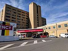
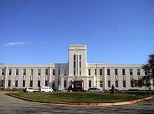
Canberra has two large public hospitals, the approximately 600-bed Canberra Hospital—formerly the Woden Valley Hospital—in Garran and the 174-bed Calvary Public Hospital in Bruce. Both are teaching institutions.[281][282][283][284] The largest private hospital is the Calvary John James Hospital in Deakin.[285][286] Calvary Private Hospital in Bruce and Healthscope's National Capital Private Hospital in Garran are also major healthcare providers.[281][283]
The Royal Canberra Hospital was located on Acton Peninsula on Lake Burley Griffin; it was closed in 1991 and was demolished in 1997 in a controversial and fatal implosion to facilitate construction of the National Museum of Australia.[83][130][137][287][288] The city has 10 aged care facilities. Canberra's hospitals receive emergency cases from throughout southern New South Wales,[289] and ACT Ambulance Service is one of four operational agencies of the ACT Emergency Services Authority.[290] NETS provides a dedicated ambulance service for inter-hospital transport of sick newborns within the ACT and into surrounding New South Wales.[291]
Transport
_Volgren_Optimus_bodied_Scania_K360UA_6x2-2_(Euro_VI)_at_the_intersection_of_Alinga_St_and_Northbourne_Ave_(1).jpg)

.jpg)
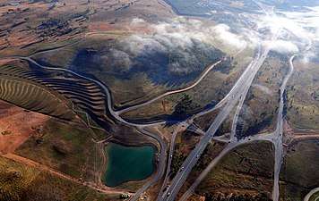
The automobile is by far the dominant form of transport in Canberra.[292] The city is laid out so that arterial roads connecting inhabited clusters run through undeveloped areas of open land or forest, which results in a low population density;[293] this also means that idle land is available for the development of future transport corridors if necessary without the need to build tunnels or acquire developed residential land. In contrast, other capital cities in Australia have substantially less green space.[294]
Canberra's districts are generally connected by parkways—limited access dual carriageway roads[292][295] with speed limits generally set at a maximum of 100 km/h (62 mph).[296][297] An example is the Tuggeranong Parkway which links Canberra's CBD and Tuggeranong, and bypasses Weston Creek.[298] In most districts, discrete residential suburbs are bounded by main arterial roads with only a few residential linking in, to deter non-local traffic from cutting through areas of housing.[299]
In an effort to improve road safety, traffic cameras were first introduced to Canberra by the Kate Carnell Government in 1999.[300] The traffic cameras installed in Canberra include fixed red-light and speed cameras and point-to-point speed cameras; together they bring in revenue of approximately $11 million per year in fines.[300]
ACTION, the government-operated bus service, provides public transport throughout the city.[301] Qcity Transit provides bus services between Canberra and nearby areas of New South Wales through their Transborder Express brand (Murrumbateman and Yass)[302] and as Qcity Transit (Queanbeyan).[303] A light rail line commenced service on 20 April 2019 linking the CBD with the northern district of Gungahlin. At the 2016 census, 7.1% of the journeys to work involved public transport, while 4.5% walked to work.[203]
There are two local taxi companies. Aerial Capital Group enjoyed monopoly status until the arrival of Cabxpress in 2007.[304] In October 2015 the ACT Government passed legislation to regulate ride sharing, allowing ride share services including Uber to operate legally in Canberra.[305][306][307] The ACT Government was the first jurisdiction in Australia to enact legislation to regulate the service.[308] Since then many other ride sharing and taxi services have started in ACT namely Ola, Glide Taxi[309] and GoCatch[310]
An interstate NSW TrainLink railway service connects Canberra to Sydney.[311] Canberra's railway station is in the inner south suburb of Kingston.[312] Between 1920 and 1922 the train line crossed the Molonglo River and ran as far north as the city centre, although the line was closed following major flooding and was never rebuilt, while plans for a line to Yass were abandoned. A 3 ft 6 in (1,067 mm) gauge construction railway was built in 1923 between the Yarralumla brickworks and the provisional Parliament House; it was later extended to Civic, but the whole line was closed in May 1927.[313] Train services to Melbourne are provided by way of a NSW TrainLink bus service which connects with a rail service between Sydney and Melbourne in Yass, about a one-hour drive from Canberra.[311][314]
Plans to establish a high-speed rail service between Melbourne, Canberra and Sydney,[315] have not been implemented, as the various proposals have been deemed economically unviable.[316][317] The original plans for Canberra included proposals for railed transport within the city,[318] however none eventuated.[318] The phase 2 report of the most recent proposal, the High Speed Rail Study, was published by the Department of Infrastructure and Transport on 11 April 2013.[319] A railway connecting Canberra to Jervis Bay was also planned but never constructed.[320]
Canberra is about three hours by road from Sydney on the Federal Highway (National Highway 23),[321] which connects with the Hume Highway (National Highway 31) near Goulburn, and seven hours by road from Melbourne on the Barton Highway (National Highway 25), which joins the Hume Highway at Yass.[321] It is a two-hour drive on the Monaro Highway (National Highway 23) to the ski fields of the Snowy Mountains and the Kosciuszko National Park.[314] Batemans Bay, a popular holiday spot on the New South Wales coast, is also two hours away via the Kings Highway.[314]
Canberra Airport provides direct domestic services to Sydney, Melbourne, Brisbane, Adelaide, Gold Coast and Perth, with connections to other domestic centres.[322] There are also direct flights to small regional towns: Dubbo and Newcastle in New South Wales. Regular commercial international flights operate to Singapore and Doha.[323][324] Canberra Airport is, as of September 2013, designated by the Australian Government Department of Infrastructure and Regional Development as a restricted use designated international airport.[325] Until 2003 the civilian airport shared runways with RAAF Base Fairbairn. In June of that year, the Air Force base was decommissioned and from that time the airport was fully under civilian control.[326]
Canberra has one of the highest rates of active travel of all Australian major cities, with 7.1 per cent of commuters walking or cycling to work in 2011.[327] An ACT Government survey conducted in late 2010 found that Canberrans walk an average of 26 minutes each day.[328] According to The Canberra Times in March 2014, Canberra's cyclists are involved in an average of four reported collisions every week.[329] The newspaper also reported that Canberra is home to 87,000 cyclists, translating to the highest cycling participation rate in Australia; and, with higher popularity, bike injury rates in 2012 were twice the national average.[330]
Utilities
The government-owned ACTEW Corporation manages Canberra's water and sewerage infrastructure.[332] ActewAGL is a joint venture between ACTEW and AGL, and is the retail provider of Canberra's utility services including water, natural gas, electricity, and also some telecommunications services via a subsidiary TransACT.[333]
Canberra's water is stored in four reservoirs, the Corin, Bendora and Cotter dams on the Cotter River and the Googong Dam on the Queanbeyan River. Although the Googong Dam is located in New South Wales, it is managed by the ACT government.[334] ACTEW Corporation owns Canberra's two wastewater treatment plants, located at Fyshwick and on the lower reaches of the Molonglo River.[335][336]
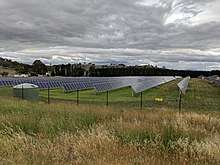
Electricity for Canberra mainly comes from the national power grid through substations at Holt and Fyshwick (via Queanbeyan).[337] Power was first supplied from the Kingston Powerhouse near the Molonglo River, a thermal plant built in 1913, but this was finally closed in 1957.[338][339] The ACT has four solar farms, which were opened between 2014 and 2017: Royalla (rated output of 20 megawatts, 2014),[340] Mount Majura (2.3 MW, 2016),[331] Mugga Lane (13 MW, 2017)[341] and Williamsdale (11 MW, 2017).[342] In addition numerous houses in Canberra have photovoltaic panels and/or solar hot water systems. In 2015/16, rooftop solar systems supported by the ACT government's feed-in tariff had a capacity of 26.3 megawatts, producing 34,910 MWh. In the same year, retailer-supported schemes had a capacity of 25.2 megawatts and exported 28,815 MWh to the grid (power consumed locally was not recorded).[343]
There are no wind-power generators in Canberra, but several have been built or are being built or planned in nearby New South Wales, such as the 140.7 megawatt Capital Wind Farm. The ACT government announced in 2013 that it was raising the target for electricity consumed in the ACT to be supplied from renewable sources to 90% by 2020,[148] raising the target from 210 to 550 megawatts.[344] It announced in February 2015 that three wind farms in Victoria and South Australia would supply 200 megawatts of capacity; these are expected to be operational by 2017.[345] Contracts for the purchase of an additional 200 megawatts of power per year from two wind farms in South Australia and New South Wales were announced in December 2015 and March 2016.[346][347] The ACT government announced in 2014 that up to 23 megawatts of feed-in-tariff entitlements would be made available for the establishment of a facility in the ACT or surrounding region for burning household and business waste to produce electricity by 2020.[348]
The ACT has the highest rate with internet access at home (94 per cent of households in 2014–15).[349]
Twin towns and sister cities
Canberra has three sister cities:
In addition, Canberra has the following friendship cities:

See also
- 1971 Canberra flood
- 2003 Canberra bushfires
- List of planned cities
- List of tallest buildings in Canberra
- Lists of capitals
Notes
- In accordance with the Australian Bureau of Statistics source, England, Scotland, Mainland China and the Special Administrative Regions of Hong Kong and Macau are listed separately
- As a percentage of 373,561 persons who nominated their ancestry at the 2016 census.
- The Australian Bureau of Statistics has stated that most who nominate "Australian" as their ancestry are part of the Anglo-Celtic group.[210]
- Of any ancestry. Includes those identifying as Aboriginal Australians or Torres Strait Islanders. Indigenous identification is separate to the ancestry question on the Australian Census and persons identifying as Aboriginal or Torres Strait Islander may identify any ancestry.
- Of any ancestry. Includes those identifying as Aboriginal Australians or Torres Strait Islanders. Indigenous identification is separate to the ancestry question on the Australian Census and persons identifying as Aboriginal or Torres Strait Islander may identify any ancestry.
References
Citations
- "3218.0 - Regional Population Growth, Australia, 2018-19". Australian Bureau of Statistics. Retrieved 28 March 2020.Estimated resident population, 30 June 2019.
- "GFS / BOM data for CANBERRA AIRPORT". Retrieved 16 June 2018.
- "Planning Data Statistics". ACT Planning & Land Authority. 21 July 2009. Archived from the original on 2 August 2008. Retrieved 13 May 2010.
- "Great Circle Distance between CANBERRA and SYDNEY". Geoscience Australia. March 2004.
- "Great Circle Distance between CANBERRA and MELBOURNE". Geoscience Australia. March 2004.
- "Great Circle Distance between CANBERRA and ADELAIDE". Geoscience Australia. March 2004.
- "Great Circle Distance between CANBERRA and BRISBANE". Geoscience Australia. March 2004.
- "Great Circle Distance between CANBERRA and PERTH". Geoscience Australia. March 2004.
- Augmented Electoral Commission for the Australian Capital Territory (July 2018). "Redistribution of the Australian Capital Territory into electoral divisions" (PDF).
The electoral divisions described in this report came into effect from Friday 13 July 2018 ... However, members of the House of Representatives will not represent or contest these electoral divisions until ... a general election.
- Macquarie Dictionary (6 ed.). Sydney: Macquarie Dictionary Publishers. 2013. Entry "Canberra". ISBN 9781876429898.
- "Canberra map". Britannica. 2013. Retrieved 28 February 2020.
- Lewis, Wendy; Balderstone, Simon; Bowan, John (2006). Events That Shaped Australia. New Holland. p. 106. ISBN 978-1-74110-492-9.
- "Role of the Assembly". Legislative Assembly for the ACT. 2010. Archived from the original on 27 May 2010. Retrieved 13 May 2010.
- "Place Names". The Australian Women's Weekly. 1932–1982: National Library of Australia. 13 May 1964. p. 61. Archived from the original on 27 March 2011. Retrieved 22 February 2011.CS1 maint: location (link)
- Frei, Patricia. "Discussion on the Meaning of 'Canberra'". Canberra History Web. Patricia Frei. Archived from the original on 27 September 2013. Retrieved 11 August 2013.
- Hull, Crispin. "European settlement and the naming of Canberra". Canberra – Australia's National Capital. Crispin Hull. Retrieved 7 June 2010.
- Cambage, Richard Hind (1919). "Part X, The Federal Capital Territory". Notes on the native flora of New South Wales. Linnean Society of New South Wales. Retrieved 14 October 2013.CS1 maint: ref=harv (link)
- Gillespie, Lyall (1984). Aborigines of the Canberra Region. Canberra: Wizard (Lyall Gillespie). pp. 1–25. ISBN 0-9590255-0-2.
- Flood, J. M.; David, B.; Magee, J.; English, B. (1987), "Birrigai: a Pleistocene site in the south eastern highlands", Archaeology in Oceania, 22: 9–22
- "Blundells Cottage". National Capital Authority. Archived from the original on 1 May 2013. Retrieved 13 May 2010.
- Canberra – Australia's capital city, Australian Government, 4 February 2010, archived from the original on 12 February 2014
- Fitzgerald 1987, p. 5.
- Gillespie 1991, pp. 3-8.
- Gillespie 1991, p. 9.
- "LETTERS". The Sydney Morning Herald. National Library of Australia. 31 January 1934. p. 6. Archived from the original on 28 July 2013. Retrieved 8 October 2012.
- Gibbney 1988, p. 48.
- Fitzgerald 1987, p. 9.
- "The Royal Military College, Duntroon" (PDF). Defence Housing Australia. p. 81. Archived from the original (PDF) on 18 March 2012. Retrieved 13 May 2010.
- Gibbney 1988, pp. 87-95.
- "Government House". Governor General of Australia. Archived from the original on 19 July 2008. Retrieved 23 April 2010.
- Sparke 1988, p. 116.
- Gillespie 1991, p. 78.
- Fitzgerald 1987, p. 17.
- Weatherill, David (2007). "Church of St John the Baptist Cemetery". The Heraldry & Genealogy Society of Canberra. Archived from the original on 3 April 2013. Retrieved 7 May 2010.
- Wilson, Randall (2012). Sanctuary in the city : the Anglican Church of St John the Baptist Canberra. The Anglican Church of St John the Baptist, Canberra. ISBN 9780646574455.
- "Sanctuary in the City". Retrieved 11 April 2020.
- "Canberra – Australia's capital city". Department of the Environment, Water, Heritage and the Arts. 4 February 2010. Archived from the original on 10 April 2011. Retrieved 23 April 2010.
- Fitzgerald 1987, p. 92.
- Gillespie 1991, pp. 220-230.
- Davison, Graeme; Hirst, John; Macintyre, Stuart, eds. (1998). The Oxford Companion to Australian History. Oxford University Press. pp. 464–465, 662–663. ISBN 9780195535976.CS1 maint: ref=harv (link)
- Wigmore 1971, p. 24.
- Fitzhardinge, L. F. (1975). Old Canberra and the search for a capital. Canberra & District Historical Society. p. 27. ISBN 0-909655-02-2.
- Fitzgerald, Alan (1987). Canberra in two centuries: A pictorial history. Clareville Press. ISBN 0-909278-02-4.
- Fitzgerald 1987, p. 93.
- Tom Lawrence, "The competition for the plan of Canberra", in supplement "Australia - 100 Years a Nation", The Canberra Times, 1 January 2001
- Fitzgerald 1987, p. 100.
- Gillespie 1991, p. 178.
- Wigmore 1971, pp. 160-166.
- Wigmore 1971, p. 63.
- Gillespie 1991, p. 303.
- "Naming the Federal Capital of Australia", Australian Screen, National Film and Sound Archive, 1913, archived from the original on 17 February 2014
- Fitzgerald 1987, p. 103.
- Australian Bureau of Statistics 1963.
- "View Naming the Federal Capital of Australia". 12 March 1913.
- Fitzgerald 1987, p. 105.
- Wigmore 1971, pp. 70-71.
- Fitzgerald 1987, p. 101.
- National Capital Development Commission 1988, p. 4.
- Wigmore 1971, pp. 69-79.
- "History of the NCA". National Capital Authority. 11 June 2009. Archived from the original on 12 February 2014. Retrieved 26 February 2010.
- "Glenloch Cork Oak Plantation". Territory and Municipal Services. Archived from the original on 21 July 2008. Retrieved 26 February 2010.
- Fitzgerald 1987, p. 130.
- Museum of Australian Democracy at Old Parliament House (12 April 2010). "Witness to history: the opening of the Provisional Parliament House in 1927". Museum of Australian Democracy at Old Parliament House. Archived from the original on 13 May 2013.CS1 maint: ref=harv (link)
- "Ethel Bruce – Stanley Melbourne Bruce – Australia's PMs – Australia's Prime Ministers". National Archives of Australia. Archived from the original on 11 February 2014. Retrieved 23 April 2010.
- Wigmore 1971, p. 101.
- Wigmore 1971, pp. 125-128.
- Gibbney 1988, pp. 116-126.
- Fitzgerald 1987, p. 115.
- Fitzgerald 1987, p. 128.
- Wigmore 1971, p. 113.
- Stephen Wilks, "The visitation of 1939", The Canberra Times, 29 June 2000, p. 11
- Sparke 1988, p. 6.
- Sparke 1988, pp. 1-3.
- Sparke 1988, pp. 7-9.
- Minty, A. E. (1973). "Lake Burley Griffin, Australia". In Ackermann, William C.; White, Gilbert F.; Worthington, E. B. (eds.). Man-Made Lakes: Their Problems and Environmental Effects. American Geophysical Union. p. 804.CS1 maint: ref=harv (link)
- Sparke 1988, p. 30.
- Sparke 1988, pp. 31-32.
- Sparke 1988, pp. 103-104, 145, 188, 323.
- Wigmore 1971, pp. 111-120.
- Gibbney 1988, pp. 230-242.
- Sparke 1988, pp. 130-140.
- Sparke 1988, pp. 170-180.
- National Capital Development Commission 1988, p. 18.
- Sparke 1988, pp. 173-174.
- Fitzgerald 1987, p. 138.
- Gibbney 1988, p. 250.
- Sparke 1988, p. 180.
- Universal Publishers 2007, p. 6.
- "Australian Parliament House – 10 Years On". Australian Broadcasting Corporation. 5 May 1998. Archived from the original on 18 April 2010. Retrieved 23 April 2010.
- "Election timetable – 1989 Election". Elections ACT. Archived from the original on 28 March 2011. Retrieved 23 April 2010.
- "Fact sheets". Legislative Assembly for the ACT. Archived from the original on 29 March 2013. Retrieved 23 April 2010.
- "Role of the Assembly". Legislative Assembly for the ACT. Archived from the original on 27 May 2010. Retrieved 23 April 2010.
- "Past election results". Australian Broadcasting Corporation. Retrieved 31 January 2010.
- Jerga, Josh (3 December 2009). "NSW boasts first female leadership team". The Sydney Morning Herald. Fairfax Media. Archived from the original on 15 May 2012. Retrieved 13 January 2010.
- Doogan, Maria (December 2006). The Canberra Firestorm: Inquests and inquiry into four deaths and four fires between 8 and 18 January 2003 (PDF). 1. Canberra: ACT Coroners Court. Archived from the original (PDF) on 16 May 2009. Retrieved 7 June 2010.
- "About the Centenary of Canberra". Centenary of Canberra unit – ACT Government. Archived from the original on 18 February 2013. Retrieved 8 February 2013.
- "Sculpture as hot-air balloon - a whale of a commission". Media release. ACT Chief Minister and Cabinet Directorate. Retrieved 12 May 2013.
- Maher, Louise. "StellrScope: Swirling art and science". 666 ABC Canberra. ABC. Retrieved 3 April 2017.
- "Climate of Canberra Area". Bureau of Meteorology. Archived from the original on 12 July 2009. Retrieved 13 May 2010.
- "Lady luck or lucky lady?". The Queanbeyan Age. 19 July 2002. Archived from the original on 3 March 2012.
- "Canberra Nature Park: Mt Majura Nature Reserve" (PDF). ACT Government Territory and Municipal Services. 2004. Archived from the original (PDF) on 26 March 2012. Retrieved 13 May 2010.
- "Canberra Nature Park: Mt Taylor Nature Reserve" (PDF). ACT Government Territory and Municipal Services. 2004. Archived from the original (PDF) on 1 May 2013. Retrieved 24 February 2013.
- "Canberra Nature Park: Mt Ainslie Nature Reserve" (PDF). ACT Government Territory and Municipal Services. 2004. Archived from the original (PDF) on 1 May 2013. Retrieved 24 February 2013.
- "Canberra Nature Park: Mt Mugga Mugga Nature Reserve" (PDF). ACT Government Territory and Municipal Services. 2004. Archived from the original (PDF) on 1 May 2013. Retrieved 24 February 2013.
- "Canberra Nature Park: Black Mountain Nature Reserve" (PDF). ACT Government Territory and Municipal Services. 2004. Archived from the original (PDF) on 1 May 2013. Retrieved 24 February 2013.
- Penguin Books Australia 2000, p. 28.
- McLeod, Ron (2003). Inquiry into the Operational Response to the January 2003 Bushfires in the ACT (PDF). Canberra, ACT. ISBN 0-642-60216-6. Archived (PDF) from the original on 14 May 2013.CS1 maint: ref=harv (link)
- Gibbney 1988, inside cover.
- Sparke 1988, pp. 131-132.
- Sparke 1988, pp. 181-182.
- "Lake Ginninderra". ACT Government Territory and Municipal Services. Archived from the original on 28 June 2013. Retrieved 17 September 2013.
- Williams 2006, p. 260.
- Sparke 1988, pp. 4-7, 13-14.
- Scrivener Dam (PDF). National Capital Authority. pp. 1–2. Archived from the original (PDF) on 1 May 2013. Retrieved 2 June 2009.
- "Climate: Canberra – Climate graph, Temperature graph, Climate table". Climate-Data.org. Retrieved 5 September 2013.
- https://www.theguardian.com/australia-news/2020/jan/04/australian-weather-canberra-and-penrith-smash-temperature-records-that-stood-for-80-years
- "Canberra's warmest winter". abc.net.au. 31 August 2011. Retrieved 28 August 2016.
- https://climateactioncanberra.org/
- "Climate statistics for Australian locations: Canberra Airport Comparison". Bureau of Meteorology. Retrieved 3 September 2011.
- "Australia – Climate of Our Continent". Bureau of Meteorology. Archived from the original on 17 March 2009. Retrieved 13 May 2010.
- "Climate information for Canberra Aero". Bureau of Meteorology. Archived from the original on 4 June 2012. Retrieved 13 May 2010.
- "Canberra chokes on world's worst air quality as city all but shut down". 3 January 2020. Retrieved 5 January 2020.
- "Climate statistics for Australian locations: Canberra Airport Comparison (1981–2010)". Bureau of Meteorology. Retrieved 20 November 2019.
- "Climate statistics for Australian locations: Canberra Airport". Bureau of Meteorology. Retrieved 17 April 2020.
- Wigmore 1971, pp. 60-63.
- Wigmore 1971, p. 67.
- Universal Publishers 2007, pp. 10-120.
- National Capital Development Commission 1988, p. 3.
- Wigmore 1971, p. 64.
- National Capital Development Commission 1988, p. 17.
- Wigmore 1971, pp. 64-67.
- "Timeline Entries for William Morris Hughes". National Archives of Australia. Retrieved 13 May 2010.
- Universal Publishers 2007, pp. 10-60.
- Gibbney 1988, pp. 110-200.
- "About Weston Creek, Canberra". Weston Creek Community Council. Archived from the original on 8 April 2010. Retrieved 23 April 2010.
- Fitzgerald 1987, p. 167.
- "Lake Burley Griffin Interactive Map". National Capital Authority. Archived from the original on 22 May 2009. Retrieved 1 June 2009.
- Sparke 1988, pp. 154-155.
- "How to cut through the ACT's planning thicket". The Canberra Times. 2 March 2005. Archived from the original on 13 November 2011. Retrieved 13 May 2010.
- Trail, Jim (9 April 2010). "It's time to review the grand plan for Canberra, says the NCA". Australian Broadcasting Corporation. Retrieved 13 May 2010.
- "Grants of leases". ACT Planning & Land Authority. Archived from the original on 29 September 2009. Retrieved 13 May 2010.
- "Place name processes". ACT Planning & Land Authority. 11 May 2009. Archived from the original on 19 April 2013. Retrieved 10 May 2010.
- "Foreign Embassies in Australia". Department of Foreign Affairs and Trade. Archived from the original on 21 March 2015. Retrieved 23 March 2015.
- Johnston, Dorothy (September 2000). "Cyberspace and Canberra Crime Fiction". Australian Humanities Review. Archived from the original on 7 January 2011. Retrieved 13 May 2010.
- "Environmental care". www.floriadeaustralia.com. Archived from the original on 26 February 2015. Retrieved 9 March 2015.
- "Sustainability issues in Canberra – background". ACT Government. 13 June 2012. Archived from the original on 26 April 2013.CS1 maint: ref=harv (link)
- Corbell, Simon (28 August 2013). "Minister showcases Canberra's sustainability success" (Press release).
- "ACT sets 90% renewable energy target in law" (Press release). ACT Government. 4 November 2013. Retrieved 25 February 2014.
- Lawson, Kirsten (29 April 2016). "ACT commits to 100 per cent renewable energy target by 2020: Simon Corbell". The Canberra Times. Fairfax Media. Archived from the original on 28 May 2016.
- "ACT to be powered by 100pc renewable energy by 2020". Australian Broadcasting Corporation. 29 April 2016. Archived from the original on 9 June 2016.
- "Zero waste" (PDF). Residua. September 2001. Archived from the original (PDF) on 18 November 2011.CS1 maint: ref=harv (link)
- Lauer, Sandra (23 May 2007). "Reducing commercial waste going to landfill in Canberra by improving the waste management practices of micro businesses" (PDF). ACT Government. Archived from the original (PDF) on 19 May 2013.CS1 maint: ref=harv (link)
- "Canberra's waste dilemma". CityNews. Canberra. 2 March 2011. Archived from the original on 5 May 2013.CS1 maint: ref=harv (link)
- Allen, Craig (1 March 2010). "No waste". ABC News.CS1 maint: ref=harv (link)
- "Plastic Bag Ban". Canberra Connect. ACT Government. 1 November 2011.CS1 maint: ref=harv (link)
- Dyett, Kathleen (1 November 2011). "ACT bag ban begins". ABC News. Archived from the original on 12 January 2012.
- "Bin bag sales booming". ABC News. 9 January 2012. Archived from the original on 12 January 2012.
- Nash, Lucy (18 January 2010). "No waste 2010=some waste 2010". 666 ABC Canberra. Archived from the original on 11 January 2015.CS1 maint: ref=harv (link)
- Pryor, Penny (30 October 2011). "Saving money can help save others". The Canberra Times. Fairfax Media. Archived from the original on 4 June 2012.
- "Electorates 2016 election". Elections ACT. Retrieved 9 December 2016.
- "Canberra". Australian Broadcasting Corporation. 29 December 2007. Retrieved 31 January 2010.
- "Fraser". Australian Broadcasting Corporation. 29 December 2007. Retrieved 31 January 2010.
- "Turbulent 20yrs of self-government". Australian Broadcasting Corporation. 11 May 2009. Retrieved 31 January 2010.
- Green, Antony. "2016 ACT Election Preview". Australian Broadcasting Corporation. Retrieved 9 December 2016.
- "Administration of National Land". National Capital Authority. 18 December 2008. Retrieved 13 May 2010.
- "Capital Works Overview". National Capital Authority. 23 October 2008. Retrieved 13 May 2010.
- "Maintenance and Operation of Assets". National Capital Authority. 23 October 2008. Retrieved 13 May 2010.
- Australian Capital Territory (Self-Government) Act 1988 (Cth).
- Australian Capital Territory (Self-Government) Act 1988 (Cth) Schedule 4.
- Sparke 1988, p. 289.
- "ACT Representation (House of Representatives) Act 1974 (Cth)". National Archives of Australia. Archived from the original on 16 December 2017. Retrieved 29 January 2010.
- "Senate – A.C.T." Australian Broadcasting Corporation. 6 November 2007. Retrieved 31 January 2010.
- "Frequently Asked Questions". Australian Federal Police. 19 November 2009. Archived from the original on 3 January 2010. Retrieved 21 January 2010.
- "ACT Policing". Australian Federal Police. 16 March 2010. Archived from the original on 27 January 2010. Retrieved 23 April 2010.
- "History of the Court of Appeal and the Supreme Court". The Supreme Court of the ACT. Archived from the original on 16 May 2016. Retrieved 7 March 2014.
- Laverty, Jo (21 May 2009). "The Belconnen Remand Centre". Australian Broadcasting Corporation. Retrieved 23 April 2010.
- Kittel, Nicholas (26 November 2008). "ACT prison built to meet human rights obligations". Australian Broadcasting Corporation. Archived from the original on 1 May 2013. Retrieved 23 April 2010.
- "Canberra Court List". Family Court of Australia. Retrieved 13 May 2010.
- "Court Listing". ACT Law Courts and Tribunals. Archived from the original on 2 May 2013. Retrieved 13 May 2010.
- "Crime". Australian Federal Police. ACT Policing. Retrieved 23 February 2019.
- "4510.0 – Recorded Crime – Victims, Australia, 2016". Australian Bureau of Statistics. 6 July 2017. Retrieved 7 December 2017.
- Australian Bureau of Statistics (27 June 2017). "Australian Capital Territory". 2016 Census QuickStats. Retrieved 7 December 2017.

- Australian Bureau of Statistics (27 June 2017). "Australia". 2016 Census QuickStats. Retrieved 7 December 2017.
- "CMTED Brief". ACT Government. Retrieved 29 March 2020.
- "ACT Stats, 2005". Australian Bureau of Statistics. 12 September 2005. Retrieved 13 May 2010.
- "CMTED Brief". ACT Government. Retrieved 29 March 2020.
- Janda, Michael (29 October 2009). "House prices surge as rate hike looms". Australian Broadcasting Corporation. Retrieved 13 May 2010.
- "It's official: the property market has cooled". Real Estate Institute of Australia. 9 September 2010. Archived from the original on 19 July 2008. Retrieved 7 June 2010.
- "Census of Population and Housing Australia in Profile A Regional Analysis". Australian Bureau of Statistics. 2004. Retrieved 13 May 2010.
- Clisby, Meredith (16 January 2014). "ACT still expensive place to live despite fall in rent prices". The Canberra Times. Fairfax Media. Archived from the original on 8 March 2014.
- All of the land in the ACT land is held by the government.
- s68 allows for an annual increase linked to a Rental Housing CPI index, which is usually significantly higher than CPI. For 2008 this deems an increase up to 10.12% as not excessive on the face of it.
- "CMTED Brief". ACT Government. Retrieved 29 March 2020.
- "EDA ACT Economic Indicators". EDA Australia. Retrieved 29 March 2020.
- "HMAS Harman". Royal Australian Navy. 2008. Retrieved 3 April 2013.
- "Fairbairn: Australian War Memorial". Australian War Memorial. 2010. Retrieved 23 April 2010.
- "RAAF Museum Fairbairn". RAAF Museum. 2009. Retrieved 13 May 2010.
- "No 34 Squadron". RAAF Museum. 2009. Retrieved 13 May 2010.
- Sutherland, Tracy (15 January 2007). "USFTA begins to reap results". Australian Financial Review. Archived from the original on 13 October 2009. Retrieved 17 June 2010.
- Sharma, Mahesh (2 April 2008). "HP bids for Tower Software". The Australian. Retrieved 17 June 2010.
- Colley, Andrew (2 October 2007). "HP bids for Tower Software". The Australian. Retrieved 17 June 2010.
- "Canberra Cyber Security Innovation Node launches". IT Brief. Retrieved 29 March 2020.
- Australian Bureau of Statistics (27 June 2017). "Canberra - Queanbeyan (Canberra Part)". 2016 Census QuickStats. Retrieved 29 October 2017.
- Australian Bureau of Statistics (31 October 2012). "Canberra - Queanbeyan (Canberra Part)". 2011 Census QuickStats. Retrieved 29 October 2017.
- Australian Bureau of Statistics (25 October 2007). "Community Profile Series : Canberra - Queanbeyan (Canberra Part)". 2006 Census of Population and Housing. Retrieved 29 October 2017.
- "Australian Demographic Statistics, Dec 2002". Australian Bureau of Statistics. 5 June 2003. Retrieved 7 June 2010.
- "6227.0 – Education and Work, Australia, May 2017". Australian Bureau of Statistics. 6 November 2017. Retrieved 8 December 2017.
- "Sweet charity: territory leads in giving". The Canberra Times. Fairfax Media. 4 November 2013. Archived from the original on 4 November 2013.
- https://quickstats.censusdata.abs.gov.au/census_services/getproduct/census/2016/communityprofile/8ACTE?opendocument
- Statistics, c=AU; o=Commonwealth of Australia; ou=Australian Bureau of. "Feature Article - Ethnic and Cultural Diversity in Australia (Feature Article)". www.abs.gov.au.
- https://quickstats.censusdata.abs.gov.au/census_services/getproduct/census/2016/quickstat/8ACTE?opendocument
- "University of Canberra". Department of Education, Employment and Workplace Relations. Archived from the original on 11 December 2011. Retrieved 23 April 2010.
- "Australian National University". Department of Education, Employment and Workplace Relations. Archived from the original on 27 September 2011. Retrieved 23 April 2010.
- Gibbney 1988, pp. 258-262.
- "Academic Ranking of World Universities 2004" (PDF). Institute of Higher Education, Shanghai Jiao Tong University. 2004. Archived from the original (PDF) on 27 November 2007. Retrieved 13 May 2010.
- "Canberra Campus". Australian Catholic University. 5 May 2010. Archived from the original on 27 January 2010. Retrieved 13 May 2010.
- "Canberra School of Theology". Charles Sturt University. Archived from the original on 30 April 2010. Retrieved 23 April 2010.
- "Australian Defence College". Australian Defence College. Archived from the original on 8 August 2013. Retrieved 23 April 2010.
- "Campbell". North Canberra Community Council. Archived from the original on 23 April 2011. Retrieved 23 April 2010.
- "The Program". Australian Defence Force Academy. Archived from the original on 27 August 2013. Retrieved 23 April 2010.
- "Introduction". Australian Defence Force Academy. 2 April 2009. Archived from the original on 12 November 2009. Retrieved 23 April 2010.
- "Officer Training". Defence Jobs. Retrieved 23 April 2010.
- "Campus Maps". Canberra Institute of Technology. 25 February 2010. Archived from the original on 23 August 2010. Retrieved 23 April 2010.
- UNSW strikes prime land deal with ACT Government to build $1 billion campus in central Canberra, Tom Lowrey and Tom Maddocks, ABC News Online, 2020-03-05
- "4221.0 - Schools, Australia, 2016". Australian Bureau of Statistics. 2 February 2017. Retrieved 4 March 2017.
- Barr, Andrew (2007). "Towards 2020: Renewing Our Schools – Message from the Minister". ACT Department of Education and Training. Archived from the original on 2 March 2011. Retrieved 13 May 2005.
- "Closing date for primary school". Australian Broadcasting Corporation. 29 October 2009. Retrieved 10 May 2010.
- "Tharwa, Hall schools should be reopened: committee". Australian Broadcasting Corporation. 17 September 2009. Retrieved 13 May 2010.
- "School closures report 'doesn't go far enough'". Australian Broadcasting Corporation. 18 September 2009. Archived from the original on 31 January 2010. Retrieved 13 May 2010.
- Universal Publishers 2007, pp. 1-90.
- Macdonald, Emma (8 May 2013). "Public schools win young, but lose seniors". The Canberra Times. Fairfax Media. Archived from the original on 28 February 2014.
- "Locations and opening hours". National Archives of Australia. Archived from the original on 6 October 2012. Retrieved 23 April 2010.
- "The Shine Dome". Australian Academy of Science. Retrieved 23 April 2010.
- "Visiting the High Court". High Court of Australia. Archived from the original on 17 October 2009. Retrieved 23 April 2010.
- "Visitors". Parliament of Australia. Archived from the original on 17 February 2012. Retrieved 23 April 2010.
- "Opening hours". Royal Australian Mint. Archived from the original on 18 May 2013. Retrieved 17 September 2013.
- "Outdoor and Nature". Visit Canberra. Archived from the original on 31 December 2010. Retrieved 23 April 2010.
- Copyright Act 1968 (Cth) s 201
- "Canberra Museum and Gallery". ACT Government. Archived from the original on 11 May 2013.CS1 maint: ref=harv (link)
- "Lanyon". ACT Museums and Galleries. Archived from the original on 30 October 2009. Retrieved 13 May 2010.
- "Minders of Tuggeranong Homestead". Chief Minister's Department. Retrieved 13 May 2010.
- "Mugga-Mugga". ACT Museums and Galleries. Archived from the original on 30 October 2009. Retrieved 13 May 2010.
- "Calthorpes' House". ACT Museums and Galleries. Archived from the original on 25 October 2009. Retrieved 13 May 2010.
- Atkinson, Ann; Knight, Linsay; McPhee, Margaret (1996). The Dictionary of Performing Arts in Australia: Opera, Dance, Music. Allen & Unwin. pp. 46–47. ISBN 1-86448-005-X.
- Daly, Margo (2003). Rough Guide to Australia. Rough Guides. p. 67. ISBN 1-84353-090-2.
- "Fact sheets". National Archives of Australia. Archived from the original on 9 August 2011. Retrieved 17 September 2013.
- Clarke, Jenna (9 July 2013). "Foreshore Festival axed for 2013". The Canberra Times. Fairfax Media. Archived from the original on 18 August 2013.
- Fallon, Naomi; Scanlon, Joni (11 October 2012). "Stone rolls on". The Sydney Morning Herald. Fairfax Media. Archived from the original on 5 November 2015.
- Egging, Kiel (16 September 2012), Stonefest Returns As ‘Stone Day’ – 2012 Lineup Announced, Music Feeds, archived from the original on 19 September 2012
- Vaisutis 2009, pp. 283-285.
- Universal Publishers 2007, pp. 10-12.
- Vaisutis 2009, pp. 278.
- "Canberra's international relationships". Chief Minister's Department.
- "Festival celebrates Canberra-Nara friendship". Australian Broadcasting Corporation. 26 September 2008. Archived from the original on 29 September 2008. Retrieved 23 April 2010.
- "Canberra Nara Park". ACT Government Territory and Municipal Services. 9 October 1999. Archived from the original on 17 September 2013. Retrieved 17 September 2013.
- "Speaker archive". National Press Club of Australia. Archived from the original on 19 April 2010. Retrieved 13 May 2010.
- Wigmore 1971, p. 87.
- Waterford, Jack (3 March 2013). "History of a paper anniversary". The Canberra Times. Fairfax Media. Archived from the original on 17 September 2013.
- "BMA comes of age". 666 ABC Canberra. Australian Broadcasting Corporation. 24 March 2013. Archived from the original on 7 October 2013. Retrieved 30 January 2017.
- "Bills Digest No. 132 2001–02: Broadcasting Services Amendment (Media Ownership) Bill 2002". Parliament of Australia. 21 March 2002. Archived from the original on 31 January 2013. Retrieved 25 September 2013.
- "Subscription television". TransACT. 11 June 2009. Archived from the original on 28 September 2013. Retrieved 25 September 2013.
- "Brumbies Crowned Super 12 Champions". Irish Rugby. 22 May 2004. Archived from the original on 13 October 2007. Retrieved 8 October 2007.
- "Premiership Records". NRL. Archived from the original on 29 October 2015. Retrieved 19 November 2015.
- "Canberra Stadium". Australian Institute of Sport. Archived from the original on 9 October 2007. Retrieved 9 March 2016.
- "Sydney 2000:Football". Australian Broadcasting Corporation. 1999. Archived from the original on 3 August 2007. Retrieved 8 October 2007.
- "Complete draw for 2003 Rugby World Cup". Australian Broadcasting Corporation. 2003. Retrieved 8 October 2007.
- "Caps take WNBL championship". Australian Broadcasting Corporation. 17 February 2007. Retrieved 8 October 2007.
- "Canberra downs Roar to clinch W-League title". Australian Broadcasting Corporation. 31 January 2012. Retrieved 3 February 2012.
- Hinds, Richard (1 April 2005). "Kangaroos finding capital gains taxing". The Sydney Morning Herald. Retrieved 8 October 2007.
- "Dogs, Demons to play in Canberra". Australian Broadcasting Corporation. 16 August 2006. Archived from the original on 13 October 2007. Retrieved 9 October 2007.
- "Who Rules, Aussie Rules!". AFL. 15 February 2007. Archived from the original on 5 March 2007. Retrieved 8 October 2007.
- Growden 2008, pp. 200-210.
- "Canberra Marathon". Canberra Marathon. Archived from the original on 7 August 2011. Retrieved 8 October 2007.
- Sparke 1988, p. 304.
- "History and successes". Australian Institute of Sport. Archived from the original on 18 January 2013. Retrieved 8 October 2007.
- "Boating on Lake Burley Griffin". National Capital Authority. Archived from the original on 23 September 2007. Retrieved 9 October 2007.
- "Lake Burley Griffin reopens". ABC News. Australian Broadcasting Corporation. 16 November 2007. Retrieved 26 July 2010.
- "Canberra Dragway Frequently Asked Questions" (PDF). ACT Government. 21 February 2006. Archived from the original (PDF) on 10 April 2012. Retrieved 8 October 2007.
- "Possum Bourne". Australian Broadcasting Corporation. 3 May 2003. Archived from the original on 25 April 2013. Retrieved 8 October 2007.
- Coronavirus restrictions-approved exercise in Canberra — excluding a walk around the lake, Niki Burnside, ABC News Online, 2020-04-19
- "Hospitals". ACT Health. Archived from the original on 26 March 2011. Retrieved 23 April 2010.
- "Canberra Hospital". ACT Health. Archived from the original on 16 July 2010. Retrieved 23 April 2010.
- "Contact Us & Location Map". Calvary Health Care ACT. Archived from the original on 23 March 2010. Retrieved 23 April 2010.
- "Public Hospital". Calvary Health Care ACT. Archived from the original on 18 July 2008. Retrieved 23 April 2010.
- Cronin, Fiona (12 August 2008). "Chemo crisis to hit ACT patients". The Canberra Times. Archived from the original on 13 November 2011. Retrieved 23 April 2010.
- "Welcome to Calvary John James Hospital". Calvary John James Hospital. Retrieved 23 April 2010.
- "15 years since hospital implosion tragedy". The Canberra Times. Fairfax Media. 13 July 2012. Archived from the original on 14 July 2012. Retrieved 25 September 2013.
- Reynolds, Fiona (5 November 1999). "Increasing pressure on ACT Chief Minister". A.M. Australian Broadcasting Corporation. Archived from the original on 4 November 2012. Retrieved 2 June 2009.
- "About Emergency". ACT Government Health Information. Archived from the original on 11 October 2009. Retrieved 23 April 2010.
- "About Us". ACT Emergency Services Authority. Archived from the original on 22 August 2011. Retrieved 23 April 2010.
- "What is NETS?". Newborn Emergency Transport Service. Archived from the original on 23 December 2007. Retrieved 23 April 2010.
- "Canberra's transport system" (PDF). Parliament of Australia. Archived from the original (PDF) on 7 February 2012. Retrieved 23 April 2010.
- Penguin Books Australia 2000, pp. 23-25.
- Penguin Books Australia 2000, pp. 3-6, 32-35, 53-59, 74-77, 90-91, 101-104.
- "ACT Road Hierarchy". ACT Government. 21 August 2012. Retrieved 14 February 2014.
- "Survey shows speeding at disputed camera site". Chief Minister's Department. 17 July 2007. Retrieved 23 April 2010.
- "Speeding". Australian Federal Police. 20 May 2008. Archived from the original on 12 November 2009. Retrieved 23 April 2010.
- Universal Publishers 2007, pp. 57, 67, 77.
- Universal Publishers 2007, pp. 1-100.
- Lawson, Kirsten (11 March 2014). "Impact of traffic cameras on speed put under microscope". The Canberra Times. Fairfax Media. Archived from the original on 11 March 2014.
- "Corporate". ACTION. Retrieved 25 February 2014.
- "About Us". Transborder Express. Retrieved 23 June 2017.
- "About Us". Qcity Transit. Retrieved 23 June 2017.
- "Taxi company 'not concerned' at losing monopoly". Australian Broadcasting Corporation. 3 February 2007. Archived from the original on 18 February 2011.
- "Uber launches in ACT as Canberra becomes first city to regulate ride sharing". Australian Broadcasting Commission. 31 October 2015. Archived from the original on 1 November 2015.
- McIlroy, Tom (30 October 2015). "Uber goes live in Canberra with more than 100 drivers registered". The Canberra Times. Fairfax Media. Archived from the original on 5 November 2015.
- "ACT chief minister launches regulated Uber in Canberra, calling it 'a real step forward'". The Guardian. 30 October 2015. Archived from the original on 3 November 2015.
- "Fully-regulated Uber services start in Canberra". Australian Financial Review. Fairfax Media. 30 October 2015. Archived from the original on 30 October 2015.
- "Taxis". Canberra Airport. Retrieved 30 April 2019.
- "Australian-owned ride-booking app GoCatch to begin driving Canberra Airport customers". GoCatch. Retrieved 30 April 2019.
- "Southern timetable". NSW Trainlink. 7 September 2019.
- "Travel pass agencies". CountryLink. 14 December 2009. Archived from the original on 20 February 2011. Retrieved 23 April 2010.
- Shellshear, Walter M. "Railways". Canberra's Engineering Heritage. Engineers Australia. Archived from the original on 23 July 2013. Retrieved 7 June 2010.
- Penguin Books Australia 2000, pp. 20.
- Richardson, Michael (19 July 2000). "Sydney to Canberra in 80 Minutes–by High-Speed Train". New York Times. Archived from the original on 1 May 2013. Retrieved 7 June 2010.
- "Oz HSR Received?". The Australian. 29 October 2002. Archived from the original on 6 March 2012. Retrieved 7 June 2010.
- Somer, Belinda (14 June 2001). "Govt considers rail link between eastern cities". Australian Broadcasting Corporation. Retrieved 7 June 2010.
- MacDonald, B.T. (May 1967). "Railways in the Australian Capital Territory". Australian Railway Historical Society Bulletin: 106–116.CS1 maint: ref=harv (link)
- AECOM; Booz and Co; KPMG; Hyder; Acil Tasman; Grimshaw Architects (April 2013). "High Speed Rail Study Phase 2 Report" (PDF). Australian Government Department of Infrastructure and Transport. Libraries Australia ID 50778307. Archived from the original (PDF) on 25 June 2013.
- Gibbney 1988, pp. 58, 60.
- Penguin Books Australia 2000, inside cover.
- "Departures". Canberra Airport. Archived from the original on 2 September 2012. Retrieved 13 May 2010.
- "Singapore Airlines announce daily flights - VisitCanberra Corporate". VisitCanberra. 24 January 2018. Archived from the original on 26 March 2019.
- Canberra - Qatar Airways, Qatar Airways, archived from the original on 20 October 2019
- "Designated International Airports in Australia". Australian Government Department of Infrastructure and Regional Development. 27 February 2013. Archived from the original on 10 May 2013.
- Hogan, Richard (July 2003). "Farewell to Fairbairn". Air Force. Royal Australian Air Force. 45 (12).CS1 maint: ref=harv (link)
- Corbell, Simon (31 July 2013). "Canberra ranks highly in national report" (Press release). Archived from the original on 18 March 2014.
- Transport for Canberra: Transport for a sustainable city 2012–31 (PDF), ACT Government, March 2012, p. 38, archived from the original (PDF) on 31 January 2014
- Thomson, Phillip (19 March 2014). "Costs add up as more cyclists take to public roads and suffer tumbles". Archived from the original on 19 March 2014.
- Thistleton, John (25 June 2014). "Cycling campaign group Pedal Power slams ACT government on injury rates". The Canberra Times. Fairfax Media. Archived from the original on 25 June 2014.
- "Mount Majura Solar Farm powers up in ACT". Solar Choice. 11 October 2016. Retrieved 6 January 2016.
- "What we do". ACTEW. Archived from the original on 3 April 2015. Retrieved 22 March 2015.
- "About our business". ActewAGL. Archived from the original on 25 January 2014. Retrieved 25 February 2014.
- "The Water Network". ActewAGL. Archived from the original on 28 March 2015. Retrieved 22 March 2015.
- "Fyshwick Sewage Treatment Plant". ActewAGL. Archived from the original on 12 March 2015. Retrieved 22 March 2015.
- "Lower Molonglo Water Quality Control Centre". ActewAGL. Archived from the original on 12 March 2015. Retrieved 22 March 2015.
- Independent Competition and Regulatory Commission (October 2003). "Review of Contestable Electricity Infrastructure Workshop" (PDF). p. 13. Archived from the original (PDF) on 20 April 2013. Retrieved 10 May 2010.
- "The Founding of Canberra". The Sydney Morning Herald. 14 March 1913. p. 5. Archived from the original on 18 February 2014.
- "20048. Kingston Powerhouse Historic Precinct (Entry to the ACT Heritage Register)" (PDF). ACT Heritage Council. Retrieved 11 October 2014.
- "Australia's largest solar farm opens in the ACT" (Press release). ACT Government. 3 September 2014. Retrieved 11 October 2014.
- "Mugga Lane solar farm opens, bringing ACT to 35 per cent renewable energy". The Canberra Times. 2 March 2017. Archived from the original on 2 March 2017. Retrieved 1 December 2017.
- "Government unveils 36,000 new solar panels at Williamsdale". The Canberra Times. 5 October 2017. Archived from the original on 29 November 2017. Retrieved 1 December 2017.
- "2015–16 Annual Feed-in Tariff Report" (PDF). ACT Government. p. 7. Archived (PDF) from the original on 9 March 2017. Retrieved 8 December 2017.
- "Large scale feed-in tariff law expanded to meet 90% renewables target" (Press release). ACT Government. 27 February 2014. Retrieved 7 March 2014.
- "Wind auction result delivers renewable energy and economic benefits to the ACT" (Press release). ACT Government. 6 February 2015. Retrieved 10 March 2015.
- "Hornsdale achieves new record price in ACT's second wind auction" (Press release). ACT Government. 21 December 2015. Retrieved 4 March 2016.
- "New wind farm set to power more than just Canberra homes" (Press release). ACT Government. 4 March 2016. Retrieved 4 March 2016.
- "Turning waste into energy" (Press release). ACT Government. 7 March 2014. Retrieved 11 March 2014.
- "8146.0 - Household Use of Information Technology, Australia, 2014-15". Australian Bureau of Statistics. 18 February 2016. Retrieved 4 January 2017.
- "Canberra adopts New Zealand capital as sister city". ABC News. Australian Broadcasting Corporation. 7 July 2016. Archived from the original on 10 July 2016.
- Hangzhou, China, ACT Government Chief Minister and Treasury Directorate, archived from the original on 9 March 2014
- Dili, Democratic Republic of Timor-Leste, ACT Government Chief Minister and Treasury Directorate, archived from the original on 9 March 2014
Sources
- Australian Bureau of Statistics (25 January 1963). "The Australian Capital Territory, Canberra the National Capital: Fifty Years of Development". Year Book Australia. Australian Bureau of Statistics. Archived from the original on 4 June 2011.CS1 maint: ref=harv (link)
- Lake Burley Griffin, Canberra: Policy Plan. Canberra: National Capital Development Commission. 1988. ISBN 0-642-13957-1.
- The Penguin Australia Road Atlas. Ringwood, Victoria: Penguin Books Australia. 2000. ISBN 0-670-88980-6.
- UBD Canberra. North Ryde, New South Wales: Universal Publishers. 2007. ISBN 0-7319-1882-7.
- Fitzgerald, Alan (1987). Canberra in Two Centuries: A Pictorial History. Torrens, Australian Capital Territory: Clareville Press. ISBN 0-909278-02-4.CS1 maint: ref=harv (link)
- Gibbney, Jim (1988). Canberra 1913–1953. Canberra: Australian Government Publishing Service. ISBN 0-644-08060-4.CS1 maint: ref=harv (link)
- Gillespie, Lyall (1991). Canberra 1820–1913. Canberra: Australian Government Publishing Service. ISBN 0-644-08060-4.CS1 maint: ref=harv (link)
- Growden, Greg (2008). Jack Fingleton: The Man Who Stood Up To Bradman. Crows Nest, New South Wales: Allen & Unwin. ISBN 978-1-74175-548-0.CS1 maint: ref=harv (link)
- Sparke, Eric (1988). Canberra 1954–1980. Canberra: Australian Government Publishing Service. ISBN 0-644-08060-4.CS1 maint: ref=harv (link)
- Vaisutis, Justine (2009). Australia. Footscray, Victoria: Lonely Planet. ISBN 1-74179-160-X.CS1 maint: ref=harv (link)
- Wigmore, Lionel (1971). Canberra: History of Australia's National Capital. Canberra: Dalton Publishing Company. ISBN 0-909906-06-8.CS1 maint: ref=harv (link)
- Williams, Dudley (2006). The Biology of Temporary Waters. Oxford: Oxford University Press. ISBN 0-19-852811-6.CS1 maint: ref=harv (link)
- Leigh, Andrew (3 October 2010). Canberra is the Best City in Australia (Speech). Festival of Dangerous Ideas. Sydney Opera House. Archived from the original on 13 September 2013. Retrieved 13 September 2013.
External links
| Wikiquote has quotations related to: Canberra |
| Wikimedia Commons has media related to Canberra. |

- WikiSatellite view of Canberra at WikiMapia
- Official Tourism Website
- The ACT Government webpage
- Canberra region map – all districts
- Canberra – Tourism Australia
- Canberra 100 – Celebrating Canberra's 100th anniversary

| General |
| |
|---|---|---|
| Cities and towns |
| |
| Localities |
| |
| Rivers |
| |
Australia portal | ||
| Authority control |
|
|---|