Anti-Lebanon Mountains
The Anti-Lebanon Mountains (Arabic: جبال لبنان الشرقية, Jibāl Lubnān ash-Sharqiyyah, lit. "Eastern Mountains of Lebanon"; Lebanese Arabic: جبال الشرقية, Jbel esh-Shar'iyyeh, "Eastern Mountains") are a southwest-northeast-trending mountain range that forms most of the border between Syria and Lebanon. The border is largely defined along the crest of the range. Most of the range lies in Syria.
| Anti-Lebanon Mountains | |
|---|---|
| جبال لبنان الشرقية | |
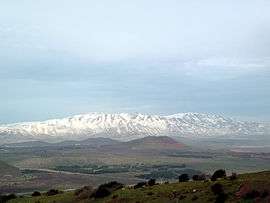 Mount Hermon, highest point in the Anti-Lebanon range, looking north from Mount Bental | |
| Highest point | |
| Peak | Mount Hermon |
| Elevation | 2,814 m (9,232 ft) |
| Dimensions | |
| Length | 150 km (93 mi) |
| Geography | |
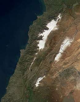 Satellite image of Lebanon. The snow-covered areas nearer the coast are the Mount Lebanon range and the snow-covered areas further inland are the Anti-Lebanon mountain range.
| |
| Location | Syria, Lebanon, Golan Heights (controlled by Israel) |
| Range coordinates | 34°N 36.5°E |
Its Western name Anti-Lebanon comes from the Greek and Latin Antilibanus, derived from its position opposite and parallel to the Mount Lebanon range. It ends in the south with Mount Hermon, which borders on the Golan Heights; the Golan Heights are a different geological and geomorphological entity, but geopolitically they are often regarded together with the southern slopes of Mount Hermon, both being part of the Israeli-controlled Golan region. To the west of the Anti-Lebanon lie valleys that separate it from Mount Lebanon in central Lebanon: Beqaa Valley in the north and the Hasbani River valley in the south. To the east, in Syria, lies the Eastern Plateau, location of the city of Damascus.
The Anti-Lebanon range is approximately 150 kilometres (93 miles) in length. To the north, it extends to almost the latitude of the Syrian city of Homs. To the south, the range adjoins the lower-laying Golan Heights plateau, but includes the highest peaks, namely Mount Hermon (Jabal el-Shaykh, in Arabic), at 2,814 metres, and Ta'la't Musa, at 2,669 metres. These peaks, on the Lebanese-Syrian border, are snow-covered for much of the year.
An important smuggling route between Lebanon and Syria passes through the Anti-Lebanon Mountains[1]
The area is known for its apricot and cherry trees as well as its stone quarries.[1]
There are various endemic flora found and named after the region, (having a Latin specific epithet) including Euphorbia antilibanotica, Teucrium antilibanoticum, Valerianella antilibanotica,[2] and Iris antilibanotica.[3]
See also
- Song of Songs 4
References
- Bulos, Nabih (2017-07-31). "Lebanon's Hezbollah group insists: We're not the 'menace' Trump says we are". Los Angeles Times. ISSN 0458-3035. Retrieved 2017-09-23.
- "Eastern Mediterranean Endemic Plants". terrestrial-biozones.net. Retrieved 25 March 2016.
- "Iris antilibanotica Dinsm. is an accepted name". theplantlist.org (The Plant List). Retrieved 25 March 2016.