York Run
York Run is a tributary of Bowman Creek in Wyoming County, Pennsylvania, in the United States. It is approximately 2.3 miles (3.7 km) long and flows through Noxen Township.[1] The watershed of the creek has an area of 1.42 square miles (3.7 km2). The surficial geology in its vicinity consists of alluvium, Wisconsinan Till, alluvial fan, and Wisconsinan Ice-Contact Stratified Drift. The watershed of the stream is designated as a High-Quality Coldwater Fishery and a Migratory Fishery and the stream is Class A Wild Trout Waters.
| York Run | |
|---|---|
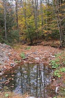
 York Run looking upstream near its mouth | |
| Physical characteristics | |
| Source | |
| ⁃ location | edge of a plateau in Noxen Township, Wyoming County, Pennsylvania |
| ⁃ elevation | between 2,060 and 2,080 feet (628 and 634 m) |
| Mouth | |
⁃ location | Bowman Creek in Noxen Township, Wyoming County, Pennsylvania |
⁃ coordinates | 41°25′39″N 76°04′01″W |
⁃ elevation | 1,014 ft (309 m) |
| Length | 2.3 mi (3.7 km) |
| Basin size | 1.42 sq mi (3.7 km2) |
| Basin features | |
| Progression | Bowman Creek → Susquehanna River → Chesapeake Bay |
Course
York Run begins near the edge of a plateau in Noxen Township. It flows east-northeast for a short distance as its valley becomes much deeper. The stream then turns east-southeast for several tenths of a mile before turning south-southeast. After several tenths of a mile, it reaches the border of the census-designated place of Noxen. It flows along the border of Noxen in a south-southeasterly direction for several tenths of a mile before reaching its confluence with Bowman Creek.[1]
York Run joins Bowman Creek 14.00 miles (22.53 km) upstream of its mouth.[2]
Hydrology
York Run is not designated as an impaired waterbody.[3] The concentration of alkalinity in York Run is 12 milligrams per liter (0.012 oz/cu ft).[4]
Mehoopany Wind Energy, LLC. once applied for and/or received a National Pollutant Discharge Elimination System to discharge stormwater into York Run during construction activities.[5]
Geography and geology
The elevation near the mouth of York Run is 1,014 feet (309 m) above sea level.[6] The elevation of the stream's source is between 2,060 and 2,080 feet (628 and 634 m) above sea level.[1]
The surficial geology near the mouth of York Run mainly consists of alluvium, alluvial fan, and Wisconsinan Ice-Contact Stratified Drift. Further upstream, the surficial geology consists of Wisconsinan Till and alluvium, but bedrock consisting of sandstone and shale is also in the area.[7]
Watershed
The watershed of York Run has an area of 1.42 square miles (3.7 km2).[2] The stream is entirely within the United States Geological Survey quadrangle of Noxen.[6]
The entire length of York Run is on private land that is closed to access.[4]
History
York Run was entered into the Geographic Names Information System on August 2, 1979. Its identifier in the Geographic Names Information System is 1199825.[6]
Biology
The drainage basin of York Run is designated as a High-Quality Coldwater Fishery and a Migratory Fishery.[8] Wild trout naturally reproduce in the stream from its headwaters downstream to its mouth.[9] It is designated by the Pennsylvania Fish and Boat Commission as Class A Wild Trout Waters for brook trout from its headwaters downstream to its mouth.[4]
In 2002, the lichen species Biatora longispora and Biatora printzenii, of the genus Biatora were observed in the vicinity of York Run.[10]
See also
- Hettesheimer Run, next tributary of Bowman Creek going downstream
- Stone Run (Bowman Creek), next tributary of Bowman Creek going upstream
- List of rivers of Pennsylvania
- List of tributaries of Bowman Creek
References
- United States Geological Survey, The National Map Viewer, archived from the original on April 5, 2012, retrieved October 11, 2015
- Pennsylvania Gazetteer of Streams (PDF), November 2, 2001, p. 154, retrieved October 11, 2015
- United States Environmental Protection Agency, Assessment Summary for Reporting Year 2006 Pennsylvania, Upper Susquehanna-Tunkhannock Watershed, retrieved October 11, 2015
- Pennsylvania Fish and Boat Commission (August 2015), Class A Wild Trout Waters (PDF), p. 24, retrieved October 11, 2015
- "VI. NPDES Discharges of Stormwater Associated with Construction Activities Individual Permit Actions", Pennsylvania Bulletin, October 8, 2011, retrieved October 11, 2015
- Geographic Names Information System, Feature Detail Report for: York Run, retrieved October 11, 2015
- Duane D. Braun (2007), Surficial geology of the Noxen 7.5-minute quadrangle, Wyoming and Luzerne Counties, Pennsylvania, p. 18, retrieved October 11, 2015
- "§ 93.9i. Drainage List I. Susquehanna River Basin in Pennsylvania Susquehanna River", Pennsylvania Code, retrieved October 11, 2015
- Pennsylvania Fish and Boat Commission (August 2015), Pennsylvania Wild Trout Waters (Natural Reproduction) - August 2015 (PDF), p. 106, retrieved October 11, 2015
- Consortium of North American Lichen Herbaria, Specimen Records, retrieved July 21, 2016