Yoncalla, Oregon
Yoncalla is a city in Douglas County, Oregon, United States. The population was 1,047 at the 2010 census.[5]
Yoncalla, Oregon | |
|---|---|
 | |
| Nickname(s): Home of the Eagles | |
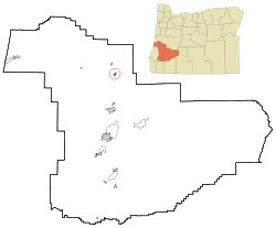 Location in Oregon | |
| Coordinates: 43°35′57″N 123°17′8″W | |
| Country | United States |
| State | Oregon |
| County | Douglas |
| Incorporated | February 27, 1901 |
| Government | |
| • Mayor | Ben Simons |
| Area | |
| • Total | 0.68 sq mi (1.76 km2) |
| • Land | 0.67 sq mi (1.73 km2) |
| • Water | 0.01 sq mi (0.02 km2) |
| Elevation | 360 ft (109.7 m) |
| Population | |
| • Total | 1,047 |
| • Estimate (2018)[3] | 1,078 |
| • Density | 1,611.36/sq mi (621.83/km2) |
| Time zone | UTC-8 (Pacific) |
| • Summer (DST) | UTC-7 (Pacific) |
| ZIP code | 97499 |
| Area code(s) | 541 |
| FIPS code | 41-84600[2] |
| GNIS feature ID | 1136932[4] |
| Website | www |
Geography
According to the United States Census Bureau, the city has a total area of 0.68 square miles (1.76 km2), of which, 0.67 square miles (1.74 km2) is land and 0.01 square miles (0.03 km2) is water.[6]
History
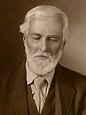
Settlers first came to the area that would become Yoncalla in a covered wagon in the fall of 1848.[7] Jesse Applegate arrived in 1849, and named the area after the Yoncalla-speaking Native Americans of the region.[8]
In 1920 the town received attention for electing a woman as mayor and an all-female city council.[7] The city elected 18-year old Ben Simons as new mayor during the 2018 midterm elections.
Demographics
| Historical population | |||
|---|---|---|---|
| Census | Pop. | %± | |
| 1910 | 233 | — | |
| 1920 | 232 | −0.4% | |
| 1930 | 252 | 8.6% | |
| 1940 | 277 | 9.9% | |
| 1950 | 626 | 126.0% | |
| 1960 | 698 | 11.5% | |
| 1970 | 675 | −3.3% | |
| 1980 | 805 | 19.3% | |
| 1990 | 919 | 14.2% | |
| 2000 | 1,052 | 14.5% | |
| 2010 | 1,047 | −0.5% | |
| Est. 2018 | 1,078 | [3] | 3.0% |
| U.S. Decennial Census[9] | |||
2010 census
As of the census of 2010, there were 1,047 people, 441 households, and 292 families living in the city. The population density was 1,562.7 inhabitants per square mile (603.4/km2). There were 476 housing units at an average density of 710.4 per square mile (274.3/km2). The racial makeup of the city was 92.3% White, 1.7% Native American, 0.5% Asian, 0.2% Pacific Islander, 1.7% from other races, and 3.6% from two or more races. Hispanic or Latino of any race were 4.6% of the population.[2]
There were 441 households of which 28.1% had children under the age of 18 living with them, 47.8% were married couples living together, 12.2% had a female householder with no husband present, 6.1% had a male householder with no wife present, and 33.8% were non-families. 27.2% of all households were made up of individuals and 14.3% had someone living alone who was 65 years of age or older. The average household size was 2.37 and the average family size was 2.82.[2]
The median age in the city was 46.8 years. 21.1% of residents were under the age of 18; 5.9% were between the ages of 18 and 24; 20.8% were from 25 to 44; 32.2% were from 45 to 64; and 20.1% were 65 years of age or older. The gender makeup of the city was 46.7% male and 53.3% female.[2]
2000 census
As of the census of 2000, there were 1,052 people, 409 households, and 287 families living in the city. The population density was 1,728.1 people per square mile (665.9/km²). There were 437 housing units at an average density of 717.8 per square mile (276.6/km²). The racial makeup of the city was 93.92% White, 0.48% Native American, 0.48% Asian, 0.57% Pacific Islander, 1.33% from other races, and 3.23% from two or more races. Hispanic or Latino of any race were 1.90% of the population.[2]
There were 409 households out of which 32.5% had children under the age of 18 living with them, 54.5% were married couples living together, 11.7% had a female householder with no husband present, and 29.8% were non-families. 23.5% of all households were made up of individuals and 11.2% had someone living alone who was 65 years of age or older. The average household size was 2.56 and the average family size was 3.00.[2]
In the city, the population was spread out with 26.5% under the age of 18, 7.7% from 18 to 24, 26.0% from 25 to 44, 23.6% from 45 to 64, and 16.3% who were 65 years of age or older. The median age was 38 years. For every 100 females, there were 96.3 males. For every 100 females age 18 and over, there were 93.7 males.[2]
The median income for a household in the city was $26,625, and the median income for a family was $31,250. Males had a median income of $26,806 versus $19,412 for females. The per capita income for the city was $13,756. About 13.3% of families and 18.3% of the population were below the poverty line, including 25.4% of those under age 18 and 17.3% of those age 65 or over.[2]
Notable people
- Jesse Applegate, pioneer who died in Yoncalla in 1888
- Rex Applegate, military officer and author
- Lily Carter, porn actress
- Rocky Gale, baseball player, catcher for San Diego Padres
- Hal Turpin, baseball player, member of Pacific Coast League Hall of Fame
References
- "2018 U.S. Gazetteer Files". United States Census Bureau. Retrieved Feb 12, 2020.
- "U.S. Census website". United States Census Bureau. Retrieved 2012-12-21.
- "Population and Housing Unit Estimates". Retrieved June 4, 2019.
- "US Board on Geographic Names". United States Geological Survey. 2007-10-25. Retrieved 2008-01-31.
- "Profile of General Population and Housing Characteristics: 2010 Demographic Profile Data (DP-1): Yoncalla city, Oregon". United States Census Bureau. Retrieved February 10, 2012.
- "US Gazetteer files 2010". United States Census Bureau. Archived from the original on February 20, 2011. Retrieved 2012-12-21.
- Torgovnick May, Kate (9 October 2016). "'We Can't Do Much Worse Than the Men'". The Atlantic. Retrieved 24 June 2018.
- "Notable Oregonians: Jesse Applegate - Pioneer". Oregon Secretary of State. Retrieved 26 June 2018.
- "Census of Population and Housing". Census.gov. Retrieved June 4, 2015.
External links
| Wikimedia Commons has media related to Yoncalla, Oregon. |
Municipalities and communities of Douglas County, Oregon, United States | ||
|---|---|---|
| Cities | 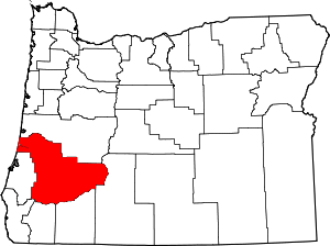 Douglas County map | |
| CDPs | ||
| Unincorporated communities | ||
| Indian reservations | ||
| Footnotes | ‡This populated place also has portions in an adjacent county or counties | |
| Authority control |
|
|---|