Yibna Bridge
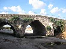
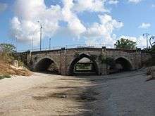
The Yibna Bridge is a Mamluk arch bridge near Yibna, which crosses the river Nahal Sorek (formerly known as Nahr Rubin, or Wadi al-Tahuna). It was previously used by Route 410 to Rehovot, and was known as the Jumping Bridge due to a bump in the middle of the bridge which caused cars to jump if speeding.[1] It is now a part of a recreation ground, next to a new bridge carrying the Route 410.
Yibna Bridge | |
|---|---|
 | |
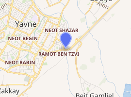
| Coordinates | 31°54′N 34°48′E |
| Crosses | Nahal Sorek |
| Locale | Yibna, Israel |
| Official name | Yibna Bridge |
| Characteristics | |
| Design | Arch |
| Total length | 48 metres |
| Width | 11.5 metres |
| History | |
| Opened | 1273–74 CE |
| |
History
The bridge was one in a series of bridges built by Sultan Baybars in Egypt and Palestine. It was first studied in modern times by Clermont-Ganneau, who noted that an Arabic chronicle had referred to the construction by Baybars in 672 AH of two bridges build of a significant nature "in the neighbourhood of Ramleh". The chief purpose of these bridges was to ease communication for his armies between Egypt and northern Syria.[2] The second of these two bridges is thought to be the Jisr Jindas.[2]
According to Clermont-Ganneau, the bridge was built in 671–672 AH (1273–1274).[3] The Archaeology of Society in the Holy Land cites the completion date as 1273.[4]
Max van Berchem, who examined it in the late 19th century, found that the bridge contained large amount of reused Crusader masonry, some of which carried mason´s marks.[5]
Description
The bridge is 48 metres (157 ft) long, and 11.5 metres (38 ft) wide.[6] It comprises three arches, two central piers with triangular upstream-facing cutwaters and downstream-facing buttresses with sloping cills.[7]
It is very similar in design to the more well-known Jisr Jindas, apart from the width of the piers.[7] The bridge has a more than 2:1 arch-span to pier-width ratio versus approximately 1:1 at Jisr Jindas.[7]
The bridge does not contain any decoration or inscriptions, similar to that found on Jisr Jindas. However, according to Andrew Petersen there is "a possible inscription or signature" on a stone at the south end.[7]
See also
References
- Jacobs, Daniel; Shirley Eber; Francesca Silvani (1998). Israel and the Palestinian Territories. Rough Guides. p. 12. ISBN 978-1-85828-248-0.
- Clermont-Ganneau, 1896, ARP II, pp. 110–117
- Clermont-Ganneau, 1896, ARP II, p. 174; Reinecke, 1992, II, 38 No. 170. Both cited in Petersen, 2001, p. 318
- Levy, 1995, p. 517
- Clermont-Ganneau, 1896, ARP II, p. 182 Also cited in Petersen, 2001, p. 318
- Petersen, 2001, p. 318
- Petersen, 2010, p. 297
Bibliography
- Clermont-Ganneau, C.S. (1896). [ARP] Archaeological Researches in Palestine 1873–1874, translated from the French by J. McFarlane. 2. London: Palestine Exploration Fund.
- Levy, T.E. (1995). Archaeology of Society in the Holy Land. A&C Black. ISBN 0718513886.
- Meinecke, M. (1992). Die mamlukishe Architecktur in Agypten und Syrien. 2. Gluckstadt.
- Petersen, Andrew (2001). A Gazetteer of Buildings in Muslim Palestine: Volume I (British Academy Monographs in Archaeology). Oxford University Press. ISBN 9780197270110.
- Petersen, A. (2010): Bridges in Medieval Palestine, in U. Vermeulen & K. Dhulster (eds.), History of Egypt & Syria in the Fatimid, Ayyubid & Mamluk Eras V, V. Peeters, Leuven
External links
- Survey of Western Palestine, Map 13: IAA, Wikimedia commons