Yau Tong
Yau Tong (Chinese: 油塘; Jyutping: jau4 tong4) is an area of Hong Kong, located in the southeastern end of Kowloon, between Lei Yue Mun and Lam Tin, at the east shore of Victoria Harbour, west of Tseung Kwan O. Administratively, it is part of Kwun Tong District, the most densely populated district in Hong Kong.

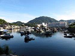
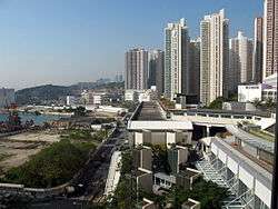
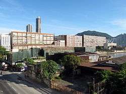

The northern part of Yau Tong is mainly residential, consisting of public housing, while the sea-facing location in the south is mainly used for industrial development. The southern area has been planned by the government as a private residential area, but there are still sporadic industrial buildings.
Yau Tong is served by the MTR station Yau Tong station. This station is on the eastern end of the Kwun Tong line and the Tseung Kwan O line, and therefore serves as an interchange point for travelling to and from Kowloon and Hong Kong Island.
Etymology
The name "Yau Tong" literally means "oil pond" in Cantonese. It was once known as 游塘, a homophone, which simply meant "pond". The English transliteration was first recorded in 1924 on a map on Devil's Peak by the government's military department.
In the Hong Kong Annual Report of 1963, two different names were used on two separate maps. The two names were "Ma Yau Tong" and "Yau Tong"; Ma Yau Tong was written on the reclamation bay, while Yau Tong was used on the zoning boundary. However, the text in the book only mentions Yau Tong, saying that the local area is only used for ship repairing and shipbuilding purposes. Because of its near-shore water storage, the government sold land to wood mills. These are special cases of political planning at that time.
The origin of "Ma Yau Tong" is disputed. One possible origin is "馬游塘“, meaning "horse pond", named after a village of the same name on Lam Tin Mountain; However, the two places are not close.
It is more likely that the name comes from the location's association with the petroleum industry. In 1947, Asia Petroleum purchased 200,000 square feet of land near the tea green to build an oil depot[1].
History
Yau Tong was largely undeveloped before 1940, and was considered a rural or suburban area. In the 1950s, an oil depot was built in Cha Kwo Ling, north of Yau Tong. In the 1960s, Yau Tong was zoned as a public housing estate along the Lei Yue Mun Road by the Hong Kong government. In 1964, a number of public housing estates such as Yau Tong Estate and Ko Chiu Road Estate were built. There was an industrial zone along the coast.
Although Yau Tong is located in Kwun Tong District, it was considered a remote area. When the MTR Kwun Tong line was opened in 1979, a plan to have a station in Yau Tong was not initially implemented. This contributed to the image of Yau Tong as a remote location.
The Eastern Harbour Crossing was opened in 1989, while Yau Tong station itself opened in 4 August 2002, along with the Tseung Kwan O line in which it is included on the same date. The increase of transport and rail links improved the connectivity of Yau Tong with Kowloon, Hong Kong Island, and the rest of Hong Kong.
With the completion of large-scale housing estates and other residences, the area became more integrated with Kowloon and was no longer seen as remote. The increase in population has led to the establishment of several primary and secondary schools in the area, including Fukien Secondary School Affiliated School and Saint Antonius Primary School.
Shopping
Yau Tong has several shopping centres. Lei Yue Mun Plaza was opened in 2001 on Lei Yue Mun Road. It is located near the MTR station. Subsequently, two more shopping centres have opened. Yau Lai Shopping Mall (油麗商場) is connected to Exit B of Yau Tong station and mainly serves residents of Yau Lai Estate.
Domain opening in 2012, is connected to Exit A of Yau Tong station, and is the largest one owned by Hong Kong Housing Authority. It serves about 80,000 people in Yau Tong Estate, Yau Lai Estate, Yau Chui Court, Yau Mei Court and Lei Yue Mun Estate.
Future development
The Town Planning Board intends to phase out industrial operations and optimize the waterfront for public enjoyment.[2] Existing factory buildings in Yau Tong Bay have been demolished successively since 2011.
Residences
Private estates
- Canaryside (鯉灣天下)
- Spectacle (嘉賢居)
- Ocean One
- Peninsula East
- One East Coast (海傲灣)
- Maya (曦臺)
Home Ownership Scheme
- Yau Tong Centre
- Ko Chun Court
- Yau Chui Court
Public housing estates
- Yau Tong Estate
- Yau Mei Court
- Lei Yue Mun Estate
- Yau Lai Estate
- Ko Yee Estate
- Ko Cheung Court
Features
Section 3 of The Wilson Trail begins at Yau Tong near Devil's Peak. It is possible to access the fort on the Peak on foot from the Wilson Trail.[3] The Tseung Kwan O Chinese Permanent Cemetery is reachable from Yau Tong.
Schools
- C.C.C Kei Faat Primary School Yau Tong (中華基督教會基法小學)
- Evangelize China Fellowship Holy Word School
- Fukien Secondary School Affiliated School (福建中學附屬學校)
- Ho Nam Kam College
- Hong Kong Taoist Association Chan Lui Chung Tak Memorial School
- Po Chiu Catholic Secondary School
- St. Antonius Girls' College
- Saint Antonius Primary School
- SKH Yautong Kei Hin Primary School
Transportation
Main road network
- Lei Yue Mun Road
- Cha Kwo Ling Road
- Ko Chiu Road
- Eastern Harbour Tunnel
Public transport
Yau Tong is served by Yau Tong Station on the MTR Kwun Tong Line and Tseung Kwan O Line, various Kowloon Motor Bus buses as well as red and green mini-buses.
Nearby districts
References
- "香港掌故[造地編]{三之三}". 大紀元時報 香港|獨立敢言的良心媒體 (in Chinese). Retrieved 2020-04-29.
- "都會規劃小組委員會二零零八年三月七日上午九時舉行 的第369次會議記錄" (PDF).
- Lai, Lawrence; Ho, Daniel; Leung, Hing Fung (2002). "Survey of the Devil's Peak redoubt and Gough Battery" (PDF). Journal of the Royal Asiatic Society Hong Kong Branch. Hong Kong. 42: 101–137 (see p.102). ISSN 1991-7295.
| Wikimedia Commons has media related to Yau Tong. |