Yatton Keynell
Yatton Keynell (pronounced "kennel") is a village and civil parish in Wiltshire, England. The village is on the B4039 road near Castle Combe, about 4 miles (6 km) northwest of Chippenham, and about the same distance to the east of the county border with South Gloucestershire.
| Yatton Keynell | |
|---|---|
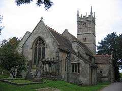 Church of St Margaret | |
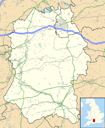 Yatton Keynell Location within Wiltshire | |
| Population | 825 (in 2011)[1] |
| OS grid reference | ST867764 |
| Unitary authority | |
| Ceremonial county | |
| Region | |
| Country | England |
| Sovereign state | United Kingdom |
| Post town | CHIPPENHAM |
| Postcode district | SN14 |
| Dialling code | 01249 |
| Police | Wiltshire |
| Fire | Dorset and Wiltshire |
| Ambulance | South Western |
| UK Parliament | |
| Website | Village |
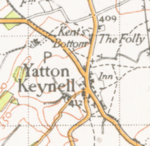
The parish includes the hamlets of Broomfield, Giddeahall, Long Dean, Tiddleywink and West Yatton. The Bybrook River forms part of the western parish boundary.
The economy of the parish was historically agricultural although it is now more of a residential area for surrounding towns; its population in the first census of 1801 was 353 and by 2001 reached 745, rising further to 825 at the 2011 census.[1] Yatton Keynell village is surrounded by a green belt and is largely a conservation area, which explains why unlike other settlements it has not expanded very much over its history.[2]
History
The village was mentioned in the Domesday Book as "Getone". Its name moved through several variations of this and the "Keynell" appears to have been added some time in the 13th century after Henry Caynell, who had a holding in 1242. At about this time, the family gave a tract of land to Stanley Abbey, and the village itself became a grange of the abbey.[2]
The Manor House is dated 1659 and is Grade II* listed.[3]
The village pub, "The Bell", takes its name from being opposite the church and dates back to the 17th century. In 1764, deeds show its name as "The Old Inn" and consisting of outhouses, stables, a brew house, garden and orchard, remains of which are still visible.[2] The adjacent road, now the B4039 to Castle Combe and beyond, was a toll road and there was a tollbooth close by as recently as 1871.[2]
A farmhouse, called Park Farmhouse, on Grittleton Road is dated to 1778 but was once known as "Small Pox Farm" and was possibly once an isolation house.[2]
An unusual milestone in the roadside wall of the rectory garden shows its distance to Hyde Park Corner, London, as 97 miles, and to Sodbury as 11 miles; the milestone is Grade II listed.[4]
The nearby hamlet of Tiddleywink made national news in 2003 following a campaign by the locals to get it officially recognised on maps.[5]
Church and chapel
Sir William Keynell built the village church in 1250 as thanks for his safe return from The Crusades; as a result, it bears the unusual dedication to St Margaret of Antioch. Its tower is 15th-century but the building was mostly restored in 1868 to a design by G E Street.[6] The church is Grade I listed.[7]
Ebenezer Baptist Chapel was built in 1835[8] and became a Congregational church in the 1870s.[9]
Facilities
The primary school in the village, By Brook Valley CE Primary School, is attended by children from surrounding villages.[10]
There is a village hall, a doctors' surgery and a shop with a post office.
Notable people
- John Aubrey, antiquary and writer, known for his descriptions of Avebury and Stonehenge, attended the church school.
- Sir Charles Snell owned land in Yatton Keynell and sold it to invest in the ship Angel Gabriel for the expedition by Raleigh to Guiana in 1595. The family owned the Manor House in West Yatton Lane from the late 17th century.[2]
Elected representatives
The village is represented in parliament by James Gray and in Wiltshire Council by Jane Scott, both Conservatives.
References
- "Yatton Keynell census information". Wiltshire Community History. Wiltshire Council. Retrieved 14 August 2015.
- "Yatton Keynell". Wiltshire Community History. Wiltshire Council. Retrieved 14 August 2015.
- Historic England. "The Manor House, Yatton Keynell (1300423)". National Heritage List for England. Retrieved 14 August 2015.
- Historic England. "Milestone in roadside wall of the rectory garden (1023026)". National Heritage List for England. Retrieved 14 August 2015.
- "Tiddleywink on the map". BBC News. 19 February 2003. Retrieved 24 August 2019.
- "Church of St. Margaret of Antioch, Yatton Keynell". Wiltshire Community History. Wiltshire Council. Retrieved 14 August 2015.
- Historic England. "Church of St Margaret of Antioch, Yatton Keynell (1356103)". National Heritage List for England. Retrieved 14 August 2015.
- "Ebenezer Baptist Chapel, Yatton Keynell". Wiltshire Community History. Wiltshire Council. Retrieved 14 August 2015.
- "Congregational Chapel, Yatton Keynell". Wiltshire Community History. Wiltshire Council. Retrieved 14 August 2015.
- "By Brook Valley C of E Primary School". Retrieved 14 August 2015.