Yanceyville, North Carolina
Yanceyville is a town in and the county seat of Caswell County, North Carolina, United States.[6] The population was 2,039 at the 2010 census.[7]
Yanceyville, North Carolina | |
|---|---|
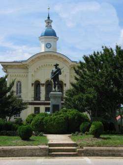 Caswell County Courthouse in Yanceyville | |
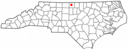 Location of Yanceyville, North Carolina | |
| Coordinates: 36°24′25″N 79°20′30″W | |
| Country | United States |
| State | North Carolina |
| County | Caswell |
| Government | |
| • Type | Council-manager |
| • Mayor | Alvin Foster [1](D) |
| • Town Manager | Brian Collie [2] |
| • North Carolina Representative | Graig R. Meyer (D) |
| Area | |
| • Total | 5.6 sq mi (14.4 km2) |
| • Land | 5.5 sq mi (14.3 km2) |
| • Water | 0.04 sq mi (0.1 km2) |
| Elevation | 617 ft (188 m) |
| Population (2010) | |
| • Total | 2,039 |
| • Estimate (2018)[3] | 1,994 |
| • Density | 370/sq mi (140/km2) |
| Time zone | UTC-5 (Eastern (EST)) |
| • Summer (DST) | UTC-4 (EDT) |
| ZIP code | 27379 |
| Area code(s) | 336 |
| FIPS code | 37-76000[4] |
| GNIS feature ID | 0997688[5] |
| Website | www |
History
It has been the county seat since 1792 (although the settlement was originally called Caswell Court House until 1833). The original Caswell County Courthouse has been renovated and provides offices for county departments. The new courthouse is located a few blocks north.
There remains uncertainty as to the person for whom Yanceyville is named. Some say it is named for James Yancey (1768–1829). Others claim it is named for his younger brother, Bartlett Yancey, Jr.(1785–1828).[8] A few believe the name honored the entire Yancey family, long prominent in the area.
In addition to the Caswell County Courthouse, the Graves House, William Henry and Sarah Holderness House, John Johnston House, Poteat House, Bartlett Yancey House, Yanceyville Historic District, and Melrose/Williamson House are listed on the National Register of Historic Places.[9][10]
Geography
Yanceyville is located at the center of Caswell County, at 36°24′25″N 79°20′30″W (36.407037, −79.341545).[11] U.S. Route 158 passes through the town, leading east 22 miles (35 km) to Roxboro and west 22 miles (35 km) to Reidsville. North Carolina Highway 86 joins US 158 in a short bypass just north of the center of town and leads 29 miles (47 km) southeast to Hillsborough and 13 miles (21 km) north to Danville, Virginia. North Carolina Highway 62 passes through the eastern side of Yanceyville, leading northeast 12 miles (19 km) to Milton and south 25 miles (40 km) to Burlington.
According to the United States Census Bureau, Yanceyville has a total area of 5.6 square miles (14.4 km2), of which 5.5 square miles (14.3 km2) is land and 0.04 square miles (0.1 km2), or 0.57%, is water.[7]
Yanceyville is considered to be a part of the Piedmont Triad.
Climate
The most pleasant months of the year for Yanceyville are May, September, and October. In Yanceyville, there are 7 months with high temperatures in the range of 70–85°. In 2018, July was the hottest month with an average high temperature of 89.1°. January is typically the coldest month in Yanceyville. The most humid months are July, August, and June.[12]
| Climate data for Yanceyviile | |||||||||||||
|---|---|---|---|---|---|---|---|---|---|---|---|---|---|
| Month | Jan | Feb | Mar | Apr | May | Jun | Jul | Aug | Sep | Oct | Nov | Dec | Year |
| Average high °F (°C) | 47.8 (8.8) |
51.6 (10.9) |
61.1 (16.2) |
70.3 (21.3) |
78.2 (25.7) |
87 (31) |
89.1 (31.7) |
87.4 (30.8) |
81 (27) |
70.6 (21.4) |
61.3 (16.3) |
50.3 (10.2) |
69.6 (20.9) |
| Average low °F (°C) | 28.2 (−2.1) |
30.3 (−0.9) |
37.8 (3.2) |
45.8 (7.7) |
55.1 (12.8) |
63.8 (17.7) |
68 (20) |
66.8 (19.3) |
58.7 (14.8) |
47.1 (8.4) |
38.5 (3.6) |
30.1 (−1.1) |
47.5 (8.6) |
| Average precipitation inches (mm) | 3.35 (85) |
3.3 (84) |
4.45 (113) |
4.07 (103) |
3.78 (96) |
3.52 (89) |
4.36 (111) |
5.8 (150) |
4.62 (117) |
3.45 (88) |
3.81 (97) |
3.49 (89) |
48. (1,200) |
| Average snowfall inches (cm) | 4 (10) |
1.1 (2.8) |
0.6 (1.5) |
0.0 (0.0) |
0 (0) |
0 (0) |
0 (0) |
0 (0) |
0 (0) |
0 (0) |
0 (0) |
1.6 (4.1) |
7.3 (19) |
| Source: xmACIS2 (Monthly Climate Normals)[13] | |||||||||||||
Government
Mayor and Town Council
- Alvin Foster, Mayor
- Odessa D. Gwynn, Mayor Pro-Tem
- Margie Badgett-Lampkin, Council Member
- Brian Massey, Council Member
- Keith Tatum, Council Member[14]
Demographics
| Historical population | |||
|---|---|---|---|
| Census | Pop. | %± | |
| 1910 | 338 | — | |
| 1950 | 1,391 | — | |
| 1960 | 1,113 | −20.0% | |
| 1970 | 1,274 | 14.5% | |
| 1990 | 1,973 | — | |
| 2000 | 2,091 | 6.0% | |
| 2010 | 2,039 | −2.5% | |
| Est. 2018 | 1,994 | [3] | −2.2% |
| U.S. Decennial Census[15] | |||
As of the census[4] of 2000, there were 2,091 people, 658 households, and 400 families residing in the town. The population density was 450.9 people per square mile (174.0/km²). There were 748 housing units at an average density of 161.3 per square mile (62.2/km²). The racial makeup of the town was 44.29% White, 53.99% African American, 0.33% Native American, 0.14% Asian, 0.33% from other races, and 0.91% from two or more races. Hispanic or Latino of any race were 1.00% of the population.
There were 658 households out of which 29.3% had children under the age of 18 living with them, 33.0% were married couples living together, 24.3% had a female householder with no husband present, and 39.2% were non-families. 36.8% of all households were made up of individuals and 19.0% had someone living alone who was 65 years of age or older. The average household size was 2.21 and the average family size was 2.88.
In the town, the population was spread out with 19.6% under the age of 18, 8.4% from 18 to 24, 32.9% from 25 to 44, 20.8% from 45 to 64, and 18.3% who were 65 years of age or older. The median age was 37 years. For every 100 females, there were 126.1 males. For every 100 females age 18 and over, there were 138.6 males.
The median income for a household in the town was $20,353, and the median income for a family was $26,417. Males had a median income of $24,632 versus $20,398 for females. The per capita income for the town was $16,956. About 23.3% of families and 27.7% of the population were below the poverty line, including 41.7% of those under age 18 and 24.1% of those age 65 or over.
In 2010, Yanceyville had the thirteenth-lowest median household income of all places in the United States with a population over 1,000.[16]
Activities
Between its amphitheater and town square, Yanceyville annually hosts the "Bright Leaf Hoedown". The "Hoedown" is a one-day outdoor festival held in late September featuring local food vendors, live entertainment, crafts and non-profit organizations, usually drawing more than 5,000 guests.
Yanceyville hosts the Caswell County Parks and Recreation Department, which features a variety of sports and activities, especially for children, and the Caswell County Civic Center, a full-size, professionally equipped stage, 912-seat auditorium, meeting and banquet facilities for up to 500, lobby art gallery and accessories which has concerts, plays and social functions.[17] The town also has the county's senior center with recreational and fitness facilities built in 2009.[18]
Media
Print media
Newspapers and periodicals that serve the Yanceyville and surrounding area include:
- The Caswell Messenger
- Danville Register & Bee
- The Herald-Sun
- The News & Record, part of the newspaper group owned by Berkshire Hathaway Corporation.[19]
- The Triad Business Journal, part of the American City Business Journals chain of business weeklies owned by Advance Publications, is based in Greensboro and covers business across the Piedmont Triad metropolitan region.
Other nearby stations
Television
Yanceyville is part of the Greensboro-High Point-Winston Salem designated market area, the 46th largest broadcast television market in the United States.[20]
Notable people
- Samuel Bason (1894–1986), late Yanceyville banker and businessman; member of the North Carolina State Senate, 1948–56
- Neal Watlington (1922–2019), Major League Baseball player
- Donna Edwards (born 1958), former U.S. representative
- Carl Willis (born 1960), former Major League Baseball Player and current pitching coach of the Cleveland Indians
- Samuel Simeon Fels (1860–1950), American businessman and philanthropist
- John H. Kerr (1873–1958), American jurist and politician
- John Kerr Jr. (congress) (1811–1879), congressional representative and jurist
- John Kerr (Virginia Congressman) (1782–1842), member of the U.S. House of Representatives
- William Louis Poteat (1856–1938), professor of biology and president of Wake Forest University, public intellectual, early advocate of Darwinian evolution
- Bartlett Yancey, Jr. (1785–1828), Democrat-Republican U.S. Congressman
- John W. Stephens (1834–1870), state senator from North Carolina, agent for the Freedmen's Bureau
- A. Oveta Fuller (born 1955), associate professor of microbiology at University of Michigan Medical School
- Jacob E. Long (1880–1955),15th Lieutenant Governor of North Carolina from 1925 to 1929 serving under Governor Angus W. McLean
- Ida Isabella Poteat (1858–1940), American artist and instructor
- The Badgett Sisters, American folk and gospel group,[21] recipients of the 1990 North Carolina Heritage Award. The trio began singing together in 1933 and consisted of sisters Celester, Connie, and Cleonia Badgett.[22]
- Calvin Graves (1804–1877), American politician, member of the North Carolina Assembly and North Carolina State Senate
- Maud Gatewood (1934-2004), American painter
See also
- Piedmont Triad
- Research Triangle Park, the largest research park in the United States located 49.7 miles southeast of Yanceyville
- Virginia International Raceway, a nearby multi-purpose road course offering auto and motorcycle racing
References
- "Mayor Alvin Foster". yanceyville.gov. Retrieved February 22, 2020.
- "Administrative Officials". yanceyville.gov. Retrieved February 22, 2020.
- "Population and Housing Unit Estimates". Retrieved December 24, 2019.
- "U.S. Census website". United States Census Bureau. Retrieved 2008-01-31.
- "US Board on Geographic Names". United States Geological Survey. 2007-10-25. Retrieved 2008-01-31.
- "Find a County". National Association of Counties. Retrieved 2011-06-07.
- "Geographic Identifiers: 2010 Demographic Profile Data (G001): Yanceyville town, North Carolina". U.S. Census Bureau, American Factfinder. Archived from the original on February 12, 2020. Retrieved December 26, 2014.
- "Bartlett Yancey (1785–1828)". RootsWeb.com. Retrieved January 4, 2013.
- "National Register Information System". National Register of Historic Places. National Park Service. July 9, 2010.
- M. Ruth Little (July 2014). "William Henry and Sarah Holderness House" (pdf). National Register of Historic Places – Nomination and Inventory. North Carolina State Historic Preservation Office. Retrieved 2015-07-01.
- "US Gazetteer files: 2010, 2000, and 1990". United States Census Bureau. 2011-02-12. Retrieved 2011-04-23.
- "Yanceyville, NC Monthly Weather". Weather.com. Retrieved January 10, 2020.
- "NOAA 1981–2010 Climate Normals". NOAA Regional Climate Centers. Retrieved 2018-01-19.
- "Meet Our Mayor and Council". Yanceyville.gov. Retrieved January 10, 2020.
- "Census of Population and Housing". Census.gov. Retrieved June 4, 2015.
- "US Census". Archived from the original on 12 February 2020. Retrieved 18 January 2014.
- "Civic Center". County of Caswell, North Carolina. Retrieved January 9, 2013.
- "Senior Center". County of Caswell, North Carolina. Retrieved January 9, 2013.
- "About us". News & Record. Retrieved January 11, 2020.
- "Nielsen DMA Boundaries". ArcGIS. Retrieved January 26, 2020.
- LLC, Zencos Consulting. "Welcome to the Arts in North Carolina!". search.ncarts.org. Retrieved 2016-04-06.
- "American Folk Music and Folklore Recordings: A Selected List 1990 (American Folklife Center, Library of Congress)". www.loc.gov. Retrieved 2016-04-06.
External links
- Town of Yanceyville official website
- Caswell County Historical Association
- Caswell County Photograph Collection
- Caswell County Cemetery Census
Municipalities and communities of Caswell County, North Carolina, United States | ||
|---|---|---|
| Towns |  | |
| Unincorporated communities | ||
| Authority control |
|
|---|