Wrynose Pass
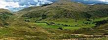
The Wrynose Pass is a mountain pass in the Lake District National Park in Cumbria, England between the Duddon Valley and Little Langdale.

Etymology
The unusual name of the pass is taken from that of the adjacent Wrynose hill, also called Wrynose Fell. The name was recorded in 12th-century documents as "Wrenhalse" and in the 16th century as "Wrenosse Hill". It is thought, based on a suggestion by Eilert Ekwall, to mean "stallion's ridge", being formed on the Old Norse words (v)reini ("stallion", probably here used as a byname for an individual), and hala. [1] It is one of a number of place names of Scandinavian origin in the area. Although most academic sources characterise "Vreini" in this context as a personal name, it has also been explained as suggesting "the horse power needed to climb it".[2] Other suggested origins are from Old Norse ravn hals, "pass of the raven",[3] and wreye nes, the "twisted headland". [4] Over the years, the name has been altered to the form "Wrynose" through folk etymology, though it is still locally pronounced "Wreynuss", much like its older form.[5]
Road
There is a single-track motor road over the pass with gradients up to 1 in 4. The pass reaches an altitude of 393m or 1,281 feet. The road continues over Hardknott Pass, whose 1 in 3 gradient is the steepest road in England, and goes on to Eskdale. The modern road overlays a Roman road for some of the route, with the Roman track visible alongside in other stretches.[6]
The pass separates the Furness Fells from the Bowfell-Crinkle Crags massif.
Shire Stones
At the top of the Wrynose Pass is the Three Shire Stone, marking the meeting point of the historic counties of Cumberland, Lancashire and Westmorland. Prior to the early 19th century, three "county stones" existed in the same spot.[7]
Farm
At the bottom of Wrynose is Fell Foot Farm, a 17th-century, Grade II listed, National Trust property.
References
- Mills, The place-names of Lancashire, Batsford, 1976, p.153
- Cooper, The Tarns of Lakeland, Warne, 1960, p. 201
- Cooper, 1960, p.201
- Smith, The Place Names of Westmorland, CUP, 1967, p.205
- Brabant, The English Lakes, Methuen, 1902, p.354
- Hindle, Roads, tracks and their interpretation, Batsford, 1993, p.44
- Green, The Tourist's New Guide: Containing a Description of the Lakes, Mountains, and Scenery, in Cumberland, Westmorland, and Lancashire, with Some Account of Their Bordering Towns and Villages. Being the Result of Observations Made During a Residence of Eighteen Years in Ambleside and Keswick, V. 2, R.Lough & Co, 1819, p.261
External links
- Map sources for Wrynose Pass