Willington Worthenbury
Willington Worthenbury (Welsh: Willington Wrddymbre) is a local government community, the lowest tier of local government, part of Wrexham County Borough and situated near the England–Wales border.
Willington Worthenbury
| |
|---|---|
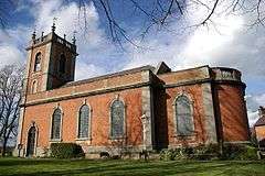 St. Deiniol's Church, Worthenbury | |
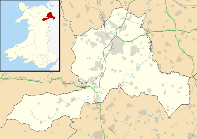 Willington Worthenbury Location within Wrexham | |
| Population | 827 (2011) |
| OS grid reference | SJ420461 |
| Community |
|
| Principal area | |
| Country | Wales |
| Sovereign state | United Kingdom |
| Post town | WREXHAM |
| Postcode district | LL13 |
| Dialling code | 01948 |
| Police | North Wales |
| Fire | North Wales |
| Ambulance | Welsh |
| UK Parliament | |
| Senedd Cymru – Welsh Parliament |
|
It has an area of 2,146 hectares and a population of 730 (2001 census), increasing to 827 at the 2011 census.[1] It contains the villages of Worthenbury and Tallarn Green.
It is located on the eastern side of the River Dee in the English Maelor area which was formerly part of the historic county of Flintshire. It has the lowest proportion of Welsh language speakers of all the communities in Wrexham county borough, with 88.81% having no knowledge of Welsh according to the 2001 census.
Settlement at Worthenbury may have begun as early as the tenth century. The name Worthenbury may stem from the Saxon name for a stronghold 'burgh', indicating that a fortification may have been situated there. There has been a parish church in the village since at least 1388. The current building was built in 1739; it is dedicated to Saint Deiniol and has many Georgian features.
South of the village lay Emral Hall, home to the influential Puleston family until 1936 when it was demolished.
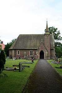
Tallarn Green also has a small church, completed in 1873 and dedicated to Mary Magdalene. The famous poet R. S. Thomas was curate here in the 1940s. The churchyard contains the war grave of a Manchester Regiment soldier of World War I.[2] The word "green" in the name of the village indicates an area of grassy common land.
References
- "Community population 2011". Retrieved 17 November 2015.
- CWGC Casualty record.
- Clwyd-Powys Archaeological Trust. Maelor Saesneg: The Settlement Landscape. Accessed 5 June 2008.
- Davies, John; Jenkins, Nigel; Baines, Menna & Lynch, Peredur I. (2008) The Welsh Academy Encyclopaedia of Wales, University of Wales Press, Cardiff.
- Roberts, Vic (2004) Worthenbury, Genuki. Accessed 5 June 2008.
- Wrexham County Borough Council. St Mary Magdalene Church. Accessed 5 June 2008.
| Wikimedia Commons has media related to Willington Worthenbury. |
| Principal settlements |  | |
|---|---|---|
| Communities |
| |
| Other villages and areas |
| |
| Castles | ||
| Buildings and structures | ||
| Rivers | ||
| Geographical features |
| |
| Topics | ||