Windy Gyle
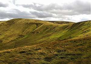
Windy Gyle is a hill in the Cheviot Hills range, on the border between England and Scotland.[4] It lies on the border ridge, and like the other hills in the area is rounded and grass-covered. Although maps show the border passing right through the summit, the summit cairn lies a few metres north of the fence that marks the border. The cairn at the summit of this hill is named Russell's Cairn and has a small depression suitable for shielding about 15 people from the wind.
| Windy Gyle | |
|---|---|
 | |
| Highest point | |
| Elevation | 619 m (2,031 ft) [1] |
| Prominence | 113 m (371 ft) [2] |
| Listing | Hu,Tu,Sim, D, Hew, N,GT,DN,BL,Bg,Y,Cm[3] |
| Coordinates | 55.43138°N 2.23068°W |
| Geography | |
| Location | Scottish Borders, Northumberland, England/Scotland |
| Parent range | Cheviot Hills |
| OS grid | NT 85538 15210 |
| Topo map | OS Landranger 80 |
The Pennine Way crosses the summit, thus providing one possible route of ascent. Windy Gyle may also be climbed from the Coquet valley to the south (England), or from Cocklawfoot to the north (Scotland).[5] There are a number or routes from both sides, and circular walks are possible.
There are good views from the summit north towards the Scottish Borders, Eildon Hills and Edinburgh.
See also
References
- https://www.hill-bagging.co.uk/mountaindetails.php?qu=S&rf=2308
- https://www.hill-bagging.co.uk/mountaindetails.php?qu=S&rf=2308
- http://www.hills-database.co.uk/database_notes.html#classification
- Ordnance Survey: Landranger map sheet 80 Cheviot Hills & Kielder Water (Map). Ordnance Survey. 2012. ISBN 9780319229668.
- O'Brien, Matthew. "The Cheviots - Windy Gyle". www.mypennines.co.uk. Retrieved 25 March 2016.