Wilbarger County Airport
Wilbarger County Airport (IATA: WIB, FAA LID: F05) is a county-owned, public-use airport in Wilbarger County, Texas, United States. It is located four nautical miles (5 mi, 7 km) north of the central business district of Vernon, Texas.[1] This airport is included in the National Plan of Integrated Airport Systems for 2011–2015, which categorized it as a general aviation facility.[2]
Wilbarger County Airport | |||||||||||||||
|---|---|---|---|---|---|---|---|---|---|---|---|---|---|---|---|
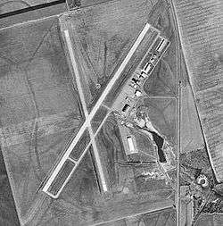 USGS 1994 orthophoto | |||||||||||||||
| Summary | |||||||||||||||
| Airport type | Public | ||||||||||||||
| Owner | Wilbarger County | ||||||||||||||
| Serves | Vernon, Texas | ||||||||||||||
| Elevation AMSL | 1,265 ft / 386 m | ||||||||||||||
| Coordinates | 34°13′32″N 099°17′02″W | ||||||||||||||
| Map | |||||||||||||||
 WIB Location of airport in Texas | |||||||||||||||
| Runways | |||||||||||||||
| |||||||||||||||
| Statistics (2008) | |||||||||||||||
| |||||||||||||||
History
Activated on September 23, 1942 as Vernon Airport. Conducted basic flying training until inactivated March 31, 1945. Primary use was basic flying training of flight cadets. Flying training was performed with Fairchild PT-19s as the primary trainer. Also had several PT-17 Stearmans and a few P-40 Warhawks assigned. Also was an auxiliary to Frederick Army Airfield, Oklahoma.
Transferred to Army Corps of Engineers on May 5, 1945. The airfield was turned over to civil control in February 1947 though the War Assets Administration.
At some point a large hangar was relocated from the nearby Victory Field onto the airport. It served the dual purpose of transient hangar and Terminal until 1974 when a new terminal building was constructed. The hangar is still used for transient aircraft storage.
Facilities and aircraft
Wilbarger County Airport covers an area of 600 acres (243 ha) at an elevation of 1,265 feet (386 m) above mean sea level. It has two asphalt paved runways: 2/20 is 5,099 by 100 feet (1,554 x 30 m) and 16/34 is 4,304 by 80 feet (1,312 x 24 m).[1]
For the 12-month period ending July 10, 2008, the airport had 9,100 aircraft operations, an average of 24 per day: 99% general aviation and 1% military. At that time there were 20 aircraft based at this airport: 75% single-engine, 20% multi-engine, and 5% ultralight.[1]
References
- FAA Airport Master Record for F05 (Form 5010 PDF). Federal Aviation Administration. Effective April 5, 2012.
- "2011–2015 NPIAS Report, Appendix A" (PDF, 2.03 MB). National Plan of Integrated Airport Systems. Federal Aviation Administration. October 4, 2010.

- Shaw, Frederick J. (2004), Locating Air Force Base Sites History’s Legacy, Air Force History and Museums Program, United States Air Force, Washington DC, 2004.
- Manning, Thomas A. (2005), History of Air Education and Training Command, 1942–2002. Office of History and Research, Headquarters, AETC, Randolph AFB, Texas ASIN: B000NYX3PC
External links
- Aerial image as of December 1994 from USGS The National Map
- FAA Terminal Procedures for F05, effective April 23, 2020
- Resources for this airport:
- FAA airport information for F05
- AirNav airport information for F05
- FlightAware airport information and live flight tracker
- SkyVector aeronautical chart for F05
| Flying Training |
|  | ||||
|---|---|---|---|---|---|---|
| Technical Training |
| |||||