Whixley
Whixley is a village and civil parish in the Harrogate district of North Yorkshire, England. It is near the A1(M) motorway and 10 miles (16 km) west of York. The ancient village of Whixley lies on Rudgate, the old Roman road along which the Roman “Hispania” Legion would have marched to nearby Isurium (Aldborough).[2][3]
| Whixley | |
|---|---|
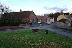 Whixley Village Hall | |
 Whixley Location within North Yorkshire | |
| Population | 824 (2011 Census)[1] |
| OS grid reference | SE443580 |
| District |
|
| Shire county | |
| Region | |
| Country | England |
| Sovereign state | United Kingdom |
| Post town | YORK |
| Postcode district | YO26 |
| Police | North Yorkshire |
| Fire | North Yorkshire |
| Ambulance | Yorkshire |
To the Normans it was Cucheslaga (recorded as Cucheslage in the Domesday Book)[4] but by the 14th century it was called Quixley after the Lord of the Manor.[5]
For many years Whixley was famous for cherries which were originally cultivated by the friars from the Priory of Knaresborough, and in later times were sold in London at Covent Garden. A great day of celebration was the annual Whixley Cherry Feast held on the first Sunday in August, The word Feast meant “festival” rather than the scoffing of huge amounts of the fruit.
Many of the houses in Whixley are a reminder of these times with Cherry House, Cherry Cottage, Cherry Tree Farm and many others.[6]
In the 17th century the Tancred family replaced the Quixleys and became Lords of the Manor, living at Whixley Hall. The last of the line was Christopher Tancred, who died in 1754, whose portrait hangs in Christ’s College, Cambridge.[7] A stone plaque on the Park Wall commemorates Christopher first having a paling fence around the Park in 1710 and the Park wall being finished in 1744, the Park to be forever stocked with 40 deer. Christopher was quite a character and there are many stories about him. His sarcophagus can be seen in the Church of the Ascension.
The Tancred estate was bought by the West Riding County Council in 1920[8] and, amid much controversy, four good farms were split up into 50 acre smallholdings to provide a living for men returning from military service in the First World War. The living of the four evicted farmers does not seem to have been given much consideration.
Today, under North Yorkshire County Council, most of these small farm houses have been sold and the land is being absorbed into larger land-ownerships, as it was 100 years ago.
In 1905 a hospital was opened on the hill-top south of Whixley. It was known as the Inebriates Reformatory but it seems to have rapidly become a dumping ground for orphans, waifs and strays for whom society could find no other place and eventually it became a mental hospital. Apart from being displaced, many of the “patients” had little wrong with them and were allowed out to help on farms at harvest time. They were known locally as the “Nibs”, short for Inebriates. Many of them lie in unmarked and forgotten graves in the churchyard. The hospital closed in 1993 and the site now forms the attractive residential development of Whixley Gate.[9]
The Church of the Ascension has looked over Whixley for over 1,000 years. Recorded in the Domesday Book of 1086,[10] the Church was burned and destroyed by marauding “Reivers” from the Scottish borders in the 13th and 14th centuries.[11] The present church was rebuilt in the 14th century and is grade II* listed.[12] Only the font and one window remain of the earlier Norman church building.[13]
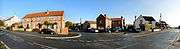 Panoramic shot of High Street, Village Shop and Anchor Inn
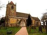 Whixley's Parish Church of the Ascension
References
- UK Census (2011). "Local Area Report – Whixley Parish (1170217102)". Nomis. Office for National Statistics. Retrieved 6 December 2018.
- Historic England. "Rudgate (1009681)". PastScape. Retrieved 6 December 2018.
- "280 Hazlewood to Whixley, The Rudgate". roadsofromanbritain.org. Retrieved 6 December 2018.
- "Whixley | Domesday Book". opendomesday.org. Retrieved 7 December 2018.
- Ekwall, Eilert (1960). The concise Oxford dictionary of English place-names (4 ed.). Oxford: Oxford University Press. p. 515. ISBN 0-19-869103-3.
- WCAA 2007, p. 5.
- Carr, William (23 September 2004). "Tancred, Christopher (1689–1754), benefactor". Oxford Dictionary of National Biography (online ed.). Oxford University Press. doi:10.1093/ref:odnb/26957. (Subscription or UK public library membership required.)
- WCAA 2007, p. 12.
- Berry, Chris (5 September 2011). "Profile on..." The Yorkshire Post. Retrieved 6 December 2018.
- Maxwell, I S (2008). "1; Yorkshire - The West Riding". In Darby, H C; Maxwell, I S (eds.). The Domesday geography of northern England (2 ed.). Cambridge: Cambridge University Press. pp. 18–19. ISBN 9780521047739.
- "Genuki: WHIXLEY, Yorkshire (West Riding)". www.genuki.org.uk. Retrieved 7 December 2018.
- Historic England. "Church of the Ascension (Grade II*) (1189906)". National Heritage List for England. Retrieved 7 December 2018.
- Pevsner, Nikolaus (2001). Ratcliffe, Enid (ed.). Yorkshire : the West Riding (2 ed.). London: Penguin Books. p. 552. ISBN 0-14-071017-5.
Sources
- Whixley Conservation Area Appraisal (PDF) (Report). Harrogate Borough Council. August 2007.