Westerdale, Highland
Westerdale (Scottish Gaelic: An Dail Shuas) is a scattered crofting village which lies on the River Thurso, located 5 miles (8 km) directly south of Halkirk, in Caithness, Highland, Scotland.[1] The B870 road passes through the village.[2]
Westerdale
| |
|---|---|
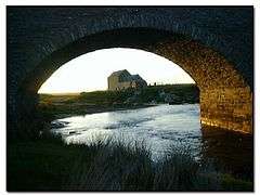 Dale Mill at Westerdale, seen through Westerdale Bridge | |
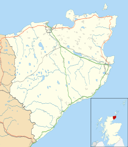 Westerdale Location within the Caithness area | |
| OS grid reference | ND128519 |
| Council area | |
| Country | Scotland |
| Sovereign state | United Kingdom |
| Post town | Halkirk |
| Postcode district | KW12 6 |
| Police | Scotland |
| Fire | Scottish |
| Ambulance | Scottish |
| UK Parliament | |
| Scottish Parliament | |
The 14th century Dirlot Castle is located 3 miles (5 km) south of the village, and was the stronghold of the Sutherlands,[3] Cheynes, Gunns and Mackays throughout its history.[4]
The River Thurso flows past the village.
References
- Microsoft; Nokia (3 January 2018). "Westerdale, Highland" (Map). Bing Maps. Microsoft. Retrieved 3 January 2018.
- "Google Maps". Google Maps. Retrieved 4 December 2019.
- Campbell, H.F. caithness and sutherland. CUP Archive. p. 65. GGKEY:KG538JF8R4E. Retrieved 3 January 2018.
- Gunn, Alastair (2014). Key issues for a Clan Gunn history. Lulu.com. p. 41. ISBN 978-1-291-73503-1. Retrieved 3 January 2018.
| Wikimedia Commons has media related to Westerdale, Highland. |
This article is issued from Wikipedia. The text is licensed under Creative Commons - Attribution - Sharealike. Additional terms may apply for the media files.