Weil (river)
The Weil is 46.6 km long river in Hesse, Germany. It is a left tributary to the Lahn river and the town of Weilburg is located next to its mouth. The river flows exclusively through the Taunus mountain range with its source being located between the Kleiner Feldberg and Großer Feldberg mountains. It flows through Schmitten, Weilrod and Weilmünster. A hiking trail as well as a biking trail follow the course of the river.
| Weil | |
|---|---|
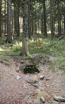 Source of the Weil. | |
| Location | |
| Country | Germany |
| Physical characteristics | |
| Source | |
| ⁃ location | Taunus |
| ⁃ elevation | 740 m (2,430 ft) |
| Mouth | |
⁃ location | Lahn |
⁃ coordinates | 50°28′26″N 8°15′50″E |
| Length | 46.6 km (29.0 mi) [1] |
| Basin size | 248 km2 (96 sq mi) [1] |
| Basin features | |
| Progression | Lahn→ Rhine→ North Sea |
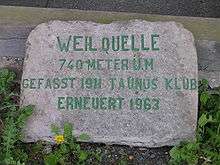
Source of the Weil 1963 by Taunusklub
References
- Kümmerly+Frey: The New International Atlas. Rand McNally (1980)
This article is issued from Wikipedia. The text is licensed under Creative Commons - Attribution - Sharealike. Additional terms may apply for the media files.