Weißach (Bregenzer Ach)
The Weißach is a 33.5-kilometre-long (20.8 mi), right-hand, eastern tributary of the Bregenzer Ach in the German and Austrian Alps. It flows into the Bregenzer Ach near Doren.
| Weißach | |
|---|---|
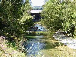 The Weißach near the Gschwendmühl Bridge near the state border | |
| Location | |
| Country | Germany and Austria |
| Reference no. | DE: 2144, AT: 811144 |
| Physical characteristics | |
| Source | |
| • location | On the Dreherberg (1,430 m above NN) |
| • coordinates | 47°32′03″N 10°09′37″E |
| • elevation | ca. 1,360 m above sea level (NN) |
| Mouth | |
• location | Between Langenegg and Doren into the Bregenzer Ach |
• coordinates | 47°28′30″N 9°51′16″E |
• elevation | 465 m (AA) |
| Length | 33.5 km (20.8 mi) [1] |
| Basin size | 216 km2 (83 sq mi) [1] |
| Basin features | |
| Progression | Bregenzer Ach→ Lake Constance→ Rhine→ North Sea |
| Tributaries | |
| • left | Bolgenach |
| • right | Eibelebach |
References
- Complete table of the Bavarian Waterbody Register by the Bavarian State Office for the Environment (xls, 10.3 MB)
This article is issued from Wikipedia. The text is licensed under Creative Commons - Attribution - Sharealike. Additional terms may apply for the media files.