Waterview, New Zealand
Waterview is a suburb of Auckland, New Zealand, located along the western side of Auckland's isthmus. Its boundaries are Oakley Creek in the east, Heron Park in the south, the Waitemata Harbour (and Motu Manawa (Pollen Island) Marine Reserve) in the west, and the Northwestern Motorway and the Oakley Creek inlet in the north.[1][2]
Waterview | |
|---|---|
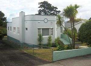 Waterview contains a variety of house styles, including a small number of Art Deco bungalows. | |
 Waterview | |
| Coordinates: 36.88°S 174.70°E | |
| Country | New Zealand |
| Local authority | Auckland Council |
| Population (2006) | |
| • Total | 3,378 |
| (Waitemata Harbour) | Point Chevalier | Point Chevalier |
| (Waitemata Harbour) |
|
Mount Albert |
| Rosebank | Avondale | Mount Albert |
Waterview is primarily a residential area, with its residents commuting to work. There are few shops: a dairy, laundromat, bakery, and a community-owned cafe.[3] Community facilities are available at Point Chevalier or Avondale, 20–30 minutes walk away.[1][2]
History
The Waterview area, especially along the coast and inlet areas, has a relatively high incidence of archeologically significant areas, from old settlement remnants (both Maori and early European settler), to a comparatively well-retained site of an old mill/tannery and quarry (Star Mill/Garret Bros Tannery) which is scheduled as a Category I Historic Place, and which once used the stream waters to drive a waterwheel.[1][2]
The population of Waterview has grown:
- 1996 census - 2898
- 2001 census - 3066
- 2006 census - 3378
- 2013 census - 3330[4]
Transport
A major issue that faced Waterview was the construction of SH20 from Hillsborough through to the Northwestern Motorway. The route through Waterview was highly contentious until (and to a degree after) a fast-tracked Board of Inquiry process consented a route in mid-2011, which placed a new motorway tunnel portal and motorway interchange at the north end of the suburb, causing the removal of numerous homes in the area.[5]
Public transport facilities from Waterview allow access to a range of destinations in Auckland City, and a shared walking and cycling path is proposed to link Waterview with Mt Albert and several other suburbs along the State Highway 16 cycle route.[6]
Education
Waterview Primary School has a student roll of about 150, and a Decile 2 rating.[7]
There is no secondary school in the suburb; nearby state secondary schools include Avondale College, Western Springs College and Mount Albert Grammar School.
References
- Waterview Connection - Assessment of Environmental Effects: Part C. New Zealand Transport Agency. August 2010. pp. 8.14–8.17.
- "My Neighbourhood: Margi Watson's Waterview". Localist. November 2011. Retrieved 22 December 2011.
- The Waterview Coffee Project
- 2013 Quickstats about Waterview
- Dearnaley, Mathew (4 September 2010). "Waterview project on fast track". The New Zealand Herald. Retrieved 4 October 2010.
- "Open Days for Waterview Shared Path". Retrieved 30 April 2015.
- Eames, David (4 July 2009). "Waterview protesters meet Joyce head-on". The New Zealand Herald. Retrieved 2 December 2011.
External links
- Photographs of Waterview held in Auckland Libraries' heritage collections.