Wariri
Wariri (Aymara wari vicuña,[2] -(i)ri a suffix, Hispanicized spelling Huarire, also Huairire) is a mountain in the Andes of southern Peru, about 4,800 metres (15,748 ft) high. It is located in the Tacna Region, Tarata Province, Susapaya District. Wariri lies between the lake Wilaquta in the north and Ñiq'i Quta ("mud lake") in the south.[1]
| Wariri | |
|---|---|
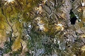 The lake Wilaquta (on the right) and Wariri south of it as seen from above (NASA Landsat7 image) | |
| Highest point | |
| Elevation | 4,800 m (15,700 ft) [1] |
| Coordinates | 17°10′55″S 70°01′25″W |
| Geography | |
 Wariri Peru | |
| Location | Peru, Tacna Region, Tarata Province |
| Parent range | Andes |
See also
References
- escale.minedu.gob.pe - UGEL map of the Tarata Province (Tacna Region)
- Radio San Gabriel, "Instituto Radiofonico de Promoción Aymara" (IRPA) 1993, Republicado por Instituto de las Lenguas y Literaturas Andinas-Amazónicas (ILLLA-A) 2011, Transcripción del Vocabulario de la Lengua Aymara, P. Ludovico Bertonio 1612 (Spanish-Aymara-Aymara-Spanish dictionary)
This article is issued from Wikipedia. The text is licensed under Creative Commons - Attribution - Sharealike. Additional terms may apply for the media files.