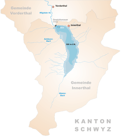
Wägitalersee
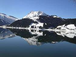
Wägitalersee is an artificial lake in Wägital, a valley in the canton of Schwyz, Switzerland. The lake is surrounded by the mountains Gross Aubrig, Fluebrig, Zindlenspitz, Brünnelistock and Bockmattli. The reservoir is located in the municipality of Innerthal.
| Wägitalersee | |
|---|---|
 | |
 Map | |
| Location | Schwyz |
| Coordinates | 47°5′22″N 8°55′16″E |
| Type | artificial lake |
| Primary inflows | Aberenbach, Schlierenbach |
| Primary outflows | Wägitaler Aa |
| Catchment area | 42.7 km2 (16.5 sq mi) |
| Basin countries | Switzerland |
| Surface area | 4.18 km2 (1.61 sq mi) |
| Max. depth | 65 m (213 ft) |
| Surface elevation | 900 m (3,000 ft) |
| Settlements | Innerthal |
The old village of Innerthal was flooded in 1924 when the dam Schräh was constructed. A new village was built on the current lake.
Economy
The primary economical purpose of the Wägitalersee is to serve as reservoir for pumped-storage hydroelectricity. The power plant and the reservoir dam became operational in 1924, thereby creating the Wägitalersee. The power plant is operated by NOK Wägital / AG Kraftwerk Wägital and produces approximately 120 million kWh of energy per year.[1]
Besides the above industrial purpose, the lake is very popular as a (nearby) recreational area for families, hikers, nature lovers and especially fishermen. The waterside is easily accessible on foot and also by car (in certain areas).
References
- "Axpo Schweiz". www.axpo.ch. Retrieved 19 June 2017.
External links
- Powerplant Operator: NOK Wägital / AG Kraftwerk Wägital
- Wägitalersee fishing and boat rental homepage
