Virginia State Route 271
State Route 271 (SR 271) is a primary state highway in the U.S. state of Virginia. Known as Pouncey Tract Road, the state highway runs 7.34 miles (11.81 km) from U.S. Route 250 (US 250) in Short Pump north to SR 620 and SR 622 in Rockville. A small section of it was first added to the state highway system as State Route 431 (SR 431) in 1930. By 1940, it had gained its current routing and designation.
| ||||
|---|---|---|---|---|
| Pouncey Tract Road | ||||
 | ||||
| Route information | ||||
| Maintained by VDOT | ||||
| Length | 7.34 mi[1] (11.81 km) | |||
| Existed | 1940–present | |||
| Major junctions | ||||
| South end | ||||
| North end | ||||
| Location | ||||
| Counties | Henrico, Goochland, Hanover | |||
| Highway system | ||||
| ||||

Route description
_at_Nuckols_Road_in_Wyndham%2C_Henrico_County%2C_Virginia.jpg)
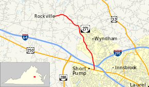
SR 271 begins at an intersection with US 250 (Broad Street) in the suburban community of Short Pump in western Henrico County. The road continues south as Pump Road. The state highway heads north as a four-lane divided highway to the east of Short Pump Town Center and crosses over Interstate 64 (I-64) just west of its western interchange with I-295. SR 271 reduces to two lanes north of the overpass and passes along the western edge of the suburban community of Wyndham. The road temporarily becomes a four-lane divided highway again by turning left at its perpendicular intersection with Nuckols Road. SR 271 leaves the suburban area as a two-lane road that cuts through the northeastern corner of Goochland County near the headwaters of the Chickahominy River to the east before entering Hanover County. The state highway continues west to its northern terminus at the intersection of SR 620 and SR 622 in the village of Rockville. SR 622 heads south as Rockville Road and north as Walnut Hill Drive; SR 620 heads west as Dogwood Trail Road.[1][2]
History
In 1930, a section of what would later become SR 271 was commissioned as SR 431, running 1.5 miles (2.4 km) northwest from State Route 41 in Short Pump to a point near Rockville.[3] During 1932, it was extended a total of 5.88 miles (9.46 km) to SR 271's current terminus as part of a larger addition of 27.44 miles (44.2 km) of undesignated roads in Henrico, Goochland, and Hanover Counties combined to the state highway system.[4] In 1933, it was redesignated State Route 160 as part of that year's state highway renumbering.[5] It received the designation of SR 271 from what is now State Route 84 during the state highway renumbering of 1940, when the latter was renumbered to match with West Virginia Route 84.[6]
Major intersections
| County | Location | mi[1] | km | Destinations | Notes | |||
|---|---|---|---|---|---|---|---|---|
| Henrico | Short Pump | 0.00 | 0.00 | |||||
| Pump Road | ||||||||
| Goochland |
No major junctions | |||||||
| Hanover | Rockville | 7.34 | 11.81 | |||||
| 1.000 mi = 1.609 km; 1.000 km = 0.621 mi | ||||||||
References
- "2017 Traffic Data". Virginia Department of Transportation. 2017. Retrieved 2020-04-11.
- Henrico County (PDF)
- Goochland County (PDF)
- Hanover County (PDF)
- Google (2011-12-29). "Virginia State Route 271" (Map). Google Maps. Google. Retrieved 2011-12-29.
- State Highway Commission of Virginia (December 18, 1930). Minutes of Meeting (PDF) (Report). Lynchburg, VA: Commonwealth of Virginia. p. 12. Retrieved 2018-09-28.
- State Highway Commission of Virginia (July 27–29, 1932). Minutes of Meeting (PDF) (Report). Marion, Roanoke, and Richmond, VA: Commonwealth of Virginia. pp. 11, 18–19. Retrieved 2018-09-28.
- Virginia State Highway Map Showing the Primary Highway System and Connections (Map). Richmond, VA: Virginia Department of Highways. July 1933. Relevant section.
- State Highway Commission of Virginia (October 10, 1940). Minutes of Meeting (PDF) (Report). Richmond, VA: Commonwealth of Virginia. pp. 15, 16. Retrieved 2018-09-28.
External links
| Wikimedia Commons has media related to Virginia State Route 271. |
- Virginia Highways Project: VA 431
- Virginia Highways Project: VA 160
- Virginia Highways Project: VA 271
| < SR 430 | District 4 State Routes 1928–1933 |
SR 432 > |