Virginia State Route 185
State Route 185 (SR 185) is a primary state highway in the U.S. state of Virginia. Known as Stoney Creek Boulevard, the state highway runs 1.00 mile (1.61 km) from SR 675 and SR 686 near Edinburg east to U.S. Route 11 (US 11) in Edinburg. SR 185 serves as a connector between Edinburg and Interstate 81 (I-81) in central Shenandoah County.
| ||||
|---|---|---|---|---|
| Stoney Creek Boulevard | ||||
 | ||||
| Route information | ||||
| Maintained by VDOT | ||||
| Length | 1.00 mi[1] (1.61 km) | |||
| Existed | 1964–present | |||
| Major junctions | ||||
| West end | ||||
| East end | ||||
| Location | ||||
| Counties | Shenandoah | |||
| Highway system | ||||
| ||||

Route description
_just_east_of_Interstate_81_and_just_west_of_Edinburg_in_Shenandoah_County%2C_Virginia.jpg)
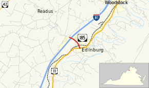
SR 185 begins at a three-way intersection at the southern end of SR 686 (South Ox Road) just west of Edinburg. The road continues west as SR 675 (Stoney Creek Road); that secondary highway has a signed concurrency with SR 185, although the secondary highway is not officially part of the primary highway. SR 185 heads southeast through a diamond interchange with I-81 and enters the town of Edinburg running parallel to Stony Creek to the south. The state highway has a grade crossing of Norfolk Southern Railway's B-Line before reaching its eastern terminus at US 11 (Main Street) at the west end of downtown Edinburg.[1][2]
Major intersections
The entire route is in Shenandoah County.
| Location | mi[1] | km | Destinations | Notes | |
|---|---|---|---|---|---|
| | 0.00 | 0.00 | |||
| | 0.08 | 0.13 | Exit 279 (I-81) | ||
| Edinburg | 1.00 | 1.61 | |||
| 1.000 mi = 1.609 km; 1.000 km = 0.621 mi | |||||
References
- "2010 Traffic Data". Virginia Department of Transportation. 2010. Retrieved 2011-11-25.
- Shenandoah County (PDF)
- Google (2011-11-25). "Virginia State Route 185" (Map). Google Maps. Google. Retrieved 2011-11-25.
External links
| Wikimedia Commons has media related to Virginia State Route 185. |