Vinland
Vinland, Vineland[2][3] or Winland[4] (Old Norse: Vínland) is the area of coastal North America explored by Norse Vikings, where Leif Erikson first landed around AD 1000, approximately five centuries prior to the voyages of Christopher Columbus and John Cabot.[5] Vinland was the name given to North America as far as it was explored by the Norse in the Vinland Sagas, presumably including both Newfoundland and the Gulf of Saint Lawrence as far as northeastern New Brunswick (where the eponymous grapevines are found). As many of the features and details of the sagas match present day knowledge of transatlantic travel and North America they are considered to be a reliable historical account. According to the historian Gisli Sigurdsson, 'The sagas are still our best proof that such voyages to the North American continent took place. Coincidence or wishful thinking simply cannot have produced descriptions of topography, natural resources and native lifestyles unknown to people in Europe that can be corroborated in North America.'[6]
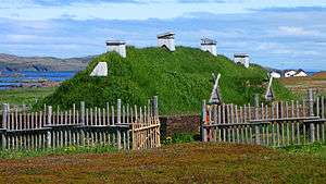
In 1960, archaeological evidence of the only known Norse site[7][8] in North America (outside Greenland) was found at L'Anse aux Meadows on the northern tip of the island of Newfoundland. Before the discovery of archaeological evidence, Vinland was known only from the sagas and medieval historiography. The 1960 discovery further proved the pre-Columbian Norse exploration of mainland North America.[7] L'Anse aux Meadows has been hypothesized to be the camp Straumfjörð mentioned in the Saga of Erik the Red.[9][10]
Name
Vinland was the name given to part of North America by the Icelandic Norseman Leif Eríksson, about AD 1000. It was also spelled Winland,[4] as early as Adam of Bremen's Descriptio insularum Aquilonis ("Description of the Northern Islands", ch. 39, in the 4th part of Gesta Hammaburgensis ecclesiae pontificum), written circa 1075. Adam's main source regarding Winland appears to have been king Svend Estridson, who had knowledge of the "northern islands". The etymology of the Old Norse root, vin- is disputed; while it has usually been assumed to be "wine", some scholars give credence to the homophone vin, meaning "pasture" or "meadow". Adam of Bremen implies that the name contains Old Norse vín (cognate with Latin vinum) "wine" (rendered as Old Saxon or Old High German wīn): "Moreover, he has also reported one island discovered by many in that ocean, which is called Winland, for the reason that grapevines grow there by themselves, producing the best wine." [11] This etymology is retained in the 13th-century Grœnlendinga saga, which provides a circumstantial account of the discovery of Vinland and its being named from the vínber, i.e. "wineberry", a term for grapes or currants (black or red), found there.[12]
There is also a long-standing Scandinavian tradition of fermenting berries into wine. The discovery of butternuts at the site implies that the Norse explored Vinland further to the south, at least as far as St. Lawrence River and parts of New Brunswick, the northern limit for both butternut and wild grapes (Vitis riparia).[9][10]
Another proposal for the name's etymology, was introduced by Sven Söderberg in 1898 (first published in 1910).[13] This suggestion involves interpreting the Old Norse name not as vín-land with the first vowel spoken as /iː/, but as vin-land, spoken as /ɪ/; a short vowel. Old Norse vin (from Proto-Norse winju) has a meaning of "meadow, pasture".[14] This interpretation of Vinland as "pasture-land" rather than "vine-land" was accepted by Valter Jansson in his classic 1951 dissertation on the vin-names of Scandinavia, by way of which it entered popular knowledge in the later 20th century. It was rejected by Einar Haugen (1977), who argued that the vin element had changed its meaning from "pasture" to "farm" long before the Old Norse period. Names in vin were given in the Proto Norse period, and they are absent from places colonized in the Viking Age. Haugen's basis for rejection has since been challenged.[15]
There is a runestone which may have contained a record of the Old Norse name slightly predating Adam of Bremen's Winland. The Hønen Runestone was discovered in Norderhov, Norway, shortly before 1817, but it was subsequently lost. Its assessment depends on a sketch made by antiquarian L. D. Klüwer (1823), now also lost but in turn copied by Wilhelm Frimann Koren Christie (1838). The Younger Futhark inscription was dated to c. 1010–1050. The stone had been erected in memory of a Norwegian, possibly a descendant of Sigurd Syr. Sophus Bugge (1902) read part of the inscription as:
ᚢᛁᚿ᛫(ᛚ)ᛆ(ᛐ)ᛁᚭ᛫ᛁᛌᛆ
uin (l)a(t)ią isa
Vínlandi á ísa
"from Vinland over ice".
This is highly uncertain; the same sequence is read by Magnus Olsen (1951) as:
ᚢᛁᚿ᛫ᚴᛆ(ᛚᛐ)ᚭ᛫ᛁᛌᛆ
uin ka(lt)ą isa
vindkalda á ísa
"over the wind-cold ice".[16]
The Vinland Sagas
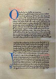
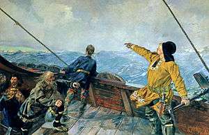
The main sources of information about the Norse voyages to Vinland are two Icelandic sagas, the Saga of Eric the Red and the Saga of the Greenlanders, which are known collectively as the Vinland Sagas. These stories were preserved by oral tradition until they were written down some 250 years after the events they describe. The existence of two versions of the story shows some of the challenges of using traditional sources for history, because they share a large number of story elements but use them in different ways. A possible example is the reference to two different men named Bjarni who are blown off course. A brief summary of the plots of the two sagas, given at the end of this article, shows other examples.
The sagas report that a considerable number of Vikings were in parties that visited Vinland. Thorfinn Karlsefni's crew consisted of 140 or 160 people according to the Saga of Eric the Red, 60 according to the Saga of the Greenlanders. Still according to the latter, Leif Ericson led a company of 35, Thorvald Eiriksson a company of 30, and Helgi and Finnbogi had 30 crew members.[17]
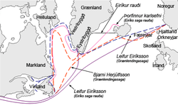
According to the Saga of Erik the Red, Þorfinnr "Karlsefni" Þórðarson and a company of 160 men, going south from Greenland traversed an open stretch of sea, found Helluland, another stretch of sea, Markland, another stretch of sea, the headland of Kjalarnes, the Wonderstrands, Straumfjörð and at last a place called Hóp, a bountiful place where no snow fell during winter. However, after several years away from Greenland, they chose to turn back to their homes when they realized that they would otherwise face an indefinite conflict with the natives.
This saga references the place-name Vinland in four ways. First, it is identified as the land found by Leif Ericson. Karlsefni and his men subsequently find "vín-ber" near the Wonderstrands. Later, the tale locates Vinland to the south of Markland, with the headland of Kjalarnes at its northern extreme. However, it also mentions that while at Straumfjord, some of the explorers wished to go in search for Vinland west of Kjalarnes.
Saga of the Greenlanders

In Grænlendinga saga or the 'Saga of the Greenlanders', Bjarni Herjólfsson accidentally discovers the new land when traveling from Norway to visit his father in the second year of Eric the Red's Greenland settlement (about 986 CE). When he does manage to reach Greenland, making land at Herjolfsness, site of his father's farm, he remains there for the rest of his father's life and does not return to Norway until about 1000 CE. There, he tells his overlord (the Earl, also named Eric) about the new land and is criticized for his long delay in reporting. On his return to Greenland he tells the story and inspires Leif Ericsson to organize an expedition, which retraces in reverse the route Bjarni had followed, past a land of flat stones (Helluland) and a land of forests (Markland). After sailing another two days across open sea, the expedition finds a headland with an island just offshore; nearby is a pool accessible to ships at high tide in an area where the sea is shallow with sandbanks. Here the explorers land and establish a base which can plausibly be matched to L'Anse aux Meadows, except that the winter is described as mild, not freezing. One day an old family servant, Tyrker, goes missing and is found mumbling to himself; he eventually explains that he has found grapes. In spring, Leif returns to Greenland with a shipload of timber towing a boatload of grapes. On the way home, he spots another ship aground on rocks, rescues the crew and later salvages the cargo. A second expedition, one ship of about 40 men, led by Leif's brother Thorvald, sets out in the autumn after Leif's return and stays over three winters at the new base (Leifsbúðir (-budir), meaning Leif's temporary shelters), exploring the west coast of the new land in the first summer, and the east coast in the second, running aground and losing the ship's keel on a headland they christen Keel Point (Kjalarnes). Further south, at a point where Thorvald would like to establish a settlement, the Greenlanders encounter some of the local inhabitants (Skrælings) and kill them, following which they are attacked by a large force in hide boats, and Thorvald dies from an arrow-wound. After the exploration party returns to base, the Greenlanders decide to return home the following spring.
Thorstein, Leif's brother, marries Gudrid, widow of the captain rescued by Leif, then leads a third expedition to bring home Thorvald's body, but is driven off course and spends the whole summer wandering the Atlantic. Spending the winter as a guest at a farm on Greenland with Gudrid, Thorstein dies of sickness, reviving just long enough to make a prophecy about her future as a Christian. The next winter, Gudrid marries a visiting Icelander named Thorfinn Karlsefni, who agrees to undertake a major expedition to Vinland, taking livestock. On arrival, they soon find a beached whale which sustains them until spring. In the summer, they are visited by some of the local inhabitants who are scared by the Greenlanders' bull but happy to trade goods for milk and other products. In autumn, Gudrid gives birth to a son, Snorri. Shortly after this, one of the local people tries to take a weapon and is killed; the explorers are then attacked in force, but manage to survive with only minor casualties by retreating to a well-chosen defensive position a short distance from their base. One of the local people picks up an iron axe, tries it, and throws it away.
The explorers return to Greenland in summer with a cargo of grapes and hides. Shortly afterwards, a ship captained by two Icelanders arrives in Greenland, and Freydis, daughter of Eric the Red, persuades them to join her in an expedition to Vinland. When they arrive to Vinland, the brothers store their stuff in Leif Eiriksson's houses, which angers Freydis and she banishes them. Then she visits them during the winter and asks for their ship claiming that she wants to go back to Greenland, which the brothers happily agree. However Freydis goes back and tells her husband the exact opposite, which leads to the killing, at Freydis' order, of all the Icelanders, including five women, as they lie sleeping. In spring the Greenlanders return home with a good cargo, but Leif finds the truth about the Icelanders. That is the last Vinland expedition recorded in the saga.
Saga of Erik the Red
In the other version of the story, Eiríks saga rauða or the Saga of Erik the Red, Leif Ericsson accidentally discovers the new land when traveling from Norway back to Greenland after a visit to his overlord, King Olaf Tryggvason, who commissions him to spread Christianity in the colony. Returning to Greenland with samples of grapes, wheat and timber, he rescues the survivors from a wrecked ship and gains a reputation for good luck; his religious mission is a swift success. The next spring, Thorstein, Leif's brother, leads an expedition to the new land but is driven off course and spends the whole summer wandering the Atlantic. On his return, he meets and marries Gudrid, one of the survivors from a ship which has made land at Herjolfsnes after a difficult voyage from Iceland. Spending the winter as a guest at a farm on Greenland with Gudrid, Thorstein dies of sickness, reviving just long enough to make a prophecy about her future as a far-traveling Christian. The next winter, Gudrid marries a visiting Icelander named Thorfinn Karlsefni, who, with his business partner Snorri Thorbrandsson, agrees to undertake a major expedition to the new land, taking livestock. Also contributing ships for this expedition are another pair of visiting Icelanders, Bjarni Grimolfsson and Thorhall Gamlason, and Leif's brother and sister Thorvald and Freydis, with her husband Thorvard. Sailing past landscapes of flat stones (Helluland) and forests (Markland) they round a cape where they see the keel of a boat (Kjalarnes), then continue past some extraordinary long beaches (Furthustrandir) before landing and sending out two runners to explore inland. After three days, the pair return with samples of grapes and wheat. After sailing a little farther, the expedition lands at an inlet next to an area of strong currents (Straumfjörð), with an island just offshore (Straumsey) and makes camp. The winter months are harsh, and food is in short supply. One day an old family servant, Thorhall the Hunter (who has not become Christian), goes missing and is found mumbling to himself; shortly afterwards, a beached whale is found which Thorhall claims has been provided in answer to his praise of the pagan gods. The explorers find that eating it makes them ill, so they pray to the Christian God, and shortly afterwards the weather improves.
When spring comes, Thorhall Gamlason, the Icelander, wants to sail north round Kjalarnes to seek Vinland, while Thorfinn Karlsefni prefers to sail southward down the east coast. Thorhall takes only nine men, and his vessel is swept out into the ocean by contrary winds; he and his crew never return. Thorfinn and Snorri, with Freydis (plus possibly Bjarni), sail down the east coast with 40 men or more and establish a camp on the shore of a seaside lake, protected by barrier islands and connected to the open ocean by a river which is navigable by ships only at high tide. The settlement was known as Hop, and the land abounds with grapes and wheat. The teller of this saga is uncertain whether the explorers remain here over the next winter (said to be very mild) or for only a few weeks of summer. One morning they see nine hide boats; the local people (Skraelings) examine the Norse ships and depart in peace. Later a much larger flotilla of boats arrives, and trade commences (Karlsefni forbids the sale of weapons). One day, the local traders are frightened by the sudden arrival of the Greenlanders' bull, and they stay away for three weeks. They then attack in force, but the explorers manage to survive with only minor casualties by retreating inland to a defensive position a short distance from their camp. Pregnancy slows Freydis down, so she picks up the sword of a fallen companion and brandishes it against her bare breast, scaring the attackers into withdrawal. One of the local people picks up an iron axe, tries it, and throws it away. The explorers subsequently abandon the southern camp and sail back to Straumsfjord, killing five natives they encounter on the way, lying asleep in hide sacks.
Karlsefni, accompanied by Thorvald Eriksson and others, sails around Kjalarnes and then south, keeping land on their left side, hoping to find Thorhall. After sailing for a long time, while moored on the south side of a west-flowing river, they are shot at by a one-footed man, and Thorvald dies from an arrow-wound. Once they reach Markland, the men encounter five natives, of whom they kidnap two boys, baptizing them and teaching them their own language.[19] The explorers return to Straumsfjord, but disagreements during the following winter lead to the abandonment of the venture. On the way home, the ship of Bjarni the Icelander is swept into the Sea of Worms (Madkasjo) by contrary winds. The marine worms destroy the hull, and only those who escape in the ship's worm-proofed boat survive. This is the last Vinland expedition recorded in the saga.[20]
Medieval geographers
The oldest commonly acknowledged surviving written record of Vinland appears in Descriptio insularum Aquilonis, by Adam of Bremen, a German (Saxon) geographer and historian, written in about 1075. To write it he visited the Danish king Svend Estridsen, who had knowledge of the northern lands and told him of the "islands" discovered by Norse sailors far out in the Atlantic, of which Vinland was the most remote. The exact phrasing of this, the first mention of Vinland in known written sources, is as follows:[21]
He also told me that in this part of the Ocean many have discovered an island, which is called Vinland because there are grapevines growing wild, which produce the best of wines. From trustworthy Danes rather than from fantastic tales, I also have heard that there is an abundance of cereal which is self-sown. Beyond this island, he (King Sven of Denmark) says, are no more inhabitable islands in the Ocean. Everything farther out is covered by immense masses of ice and perennial fog. Martianus tells of this:’ One day of sailing beyond Thule the sea is solid.’ This the widely travelled King Harold of Norway found to be true. With his ships he recently investigated the extent of the northern Ocean but finally had to turn back when the extreme limit of the world disappeared in fog before his eyes. He barely escaped the gaping ravine of the abyss.
Adam became confused between Helluland and Halagland, the northernmost part of medieval Norway, where the "midnight sun" is visible. He also spelled Vinland in Latin the same as Wendland, the Slavic province closest to Denmark.[22] In addition, Adam contradicts himself by stating that Vinland is in a location of a polar sea with "intolerable ice" and "immense fog," while also stating that the location provided the ultimate climate for the best wine to come from Greenland.[23]
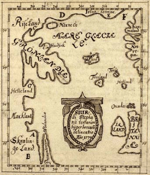
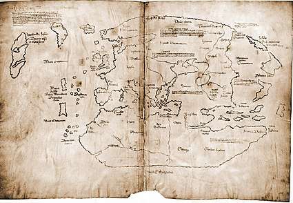
The earliest map of Vinland was drawn by Sigurd Stefansson, a schoolmaster at Skalholt, Iceland, around 1570, which placed Vinland somewhere that can be Chesapeake Bay, St. Lawrence, or Cape Cod Bay. [24]
In the early 14th Century, a geography encyclopedia called Geographica Universalis was compiled at Malmesbury Abbey in England, which was in turn used as a source for one of the most widely circulated medieval English educational works, Polychronicon by Ranulf Higden, a few years later. Both these works, with Adam of Bremen as a possible source, were confused about the location of what they called Wintland—the Malmesbury monk had it on the ocean east of Norway, while Higden put it west of Denmark but failed to explain the distance. Copies of Polychronicon commonly included a world map on which Wintland was marked in the Atlantic Ocean near Iceland, but again much closer to the Scandinavian mainland than in reality. The name was explained in both texts as referring to the savage inhabitants' ability to tie the wind up in knotted cords, which they sold to sailors who could then undo a knot whenever they needed a good wind. Neither mentioned grapes, and the Malmesbury work specifically states that little grows there but grass and trees, which reflects the saga descriptions of the area round the main Norse expedition base.[25]
More geographically correct were Icelandic texts from about the same time, which presented a clear picture of the northern countries as experienced by Norse explorers: north of Iceland a vast, barren plain (which we now know to be the Polar ice-cap) extended from Biarmeland (northern Russia) east of the White Sea, to Greenland, then further west and south were, in succession, Helluland, Markland and Vinland. The Icelanders had no knowledge of how far south Vinland extended, and they speculated that it might reach as far as Africa.[26]
The "Historia Norwegiae" (History of Norway) compiled around 1200 does not refer directly to Vinland and tries to reconcile information from Greenland with mainland European sources; in this text Greenland's territory extends so that it is "almost touching the African islands, where the waters of ocean flood in".[27]
Later Norse voyages
Icelandic chronicles record another attempt to visit Vinland from Greenland, over a century after the saga voyages. In 1121, Icelandic bishop Eric Gnupsson, who had been based on Greenland since 1112, "went to seek Vinland". Nothing more is reported of him, and three years later another bishop, Arnald, was sent to Greenland. No written records, other than inscribed stones, have survived in Greenland, so the next reference to a voyage also comes from Icelandic chronicles. In 1347, a ship arrived in Iceland, after being blown off course on its way home from Markland to Greenland with a load of timber. The implication is that the Greenlanders had continued to use Markland as a source of timber over several centuries.[28]
Controversy over the location of Vinland
The definition of Vinland is somewhat elusive. According to a 1969 article by Douglas McManis in the Annals of the Association of American Geographers,[29]
The study of the early Norse voyages to North America is a field of research characterized by controversy and conflicting, often irreconcilable, opinions and conclusions. These circumstances result from the fact that details of the voyages exist only in two Icelandic sagas which contradict each other on basic issues and internally are vague and contain nonhistorical passages.
This leads him to conclude that "there is not a Vinland, there are many Vinlands". According to a 1970 reply by Matti Kaups in the same journal,[30]
Certainly there is a symbolic Vinland as described and located in the Groenlandinga saga; what seems to be a variant of this Vinland is narrated in Erik the Red's Saga. There are, on the other hand, numerous more recent derivative Vinlands, each of which actually is but a suppositional spatial entity. (...) (e.g. Rafn's Vinland, Steensby's Vinland, Ingstad's Vinland, and so forth).
In geographical terms, Vinland is sometimes used to refer generally to all areas in North America beyond Greenland that were explored by the Norse. In the sagas, however, Vinland is sometimes indicated to not include the territories of Helluland and Markland, which appear to also be located in North America beyond Greenland. Moreover, some sagas establish vague links between Vinland and an island or territory that some sources refer to as Hvítramannaland.[31]
Another possibility is to not understand the name of Vinland as fixed to one defined location, but as merely referring to every location where vínber could be found, i.e. to understand it as a common noun, vinland, rather than as a toponym, Vinland. The Old Norse and Icelandic languages were, and are, very flexible in forming compound words.
Sixteenth century Icelanders realized that the "New World" which European geographers were calling "America" was the land described in their Vinland Sagas. The Skálholt Map, drawn in 1570 or 1590 but surviving only through later copies, shows Promontorium Winlandiae ("promontory/cape/foreland of Vinland") as a narrow cape with its northern tip at the same latitude as southern Ireland. (The scales of degrees in the map margins are inaccurate.) This effective identification of northern Newfoundland with the northern tip of Vinland was taken up by later Scandinavian scholars such as bishop Hans Resen.
Although it is generally agreed, based on the saga descriptions, that Helluland includes Baffin Island, and Markland represents at least the southern part of the modern Labrador, there has been considerable controversy over the location of the actual Norse landings and settlement. Comparison of the sagas, as summarized below, shows that they give similar descriptions and names to different places. One of the few reasonably consistent pieces of information is that exploration voyages from the main base sailed down both the east and west coasts of the land; this was one of the factors which helped archaeologists locate the site at L'Anse aux Meadows, at the tip of Newfoundland's long northern peninsula.
Erik Wahlgren examines the question in his book 'The Vikings and America', and points out clearly that L'Anse aux Meadows cannot be the location of Vínland, as the location described in the sagas has both salmon in the rivers and the 'vínber' (meaning specifically 'grape', that according to Wahlgren the explorers were familiar with and would have thus recognized), growing freely. Charting the overlap of the limits of wild vine and wild salmon habitats, Wahlgren indicates a location near New York.
Other clues appear to place the main settlement farther south, such as the mention of a winter with no snow and the reports in both sagas of grapes being found. A very specific indication in the Greenlanders' Saga of the latitude of the base has also been subject to misinterpretation. This passage states that in the shortest days of midwinter, the sun was still above the horizon at "dagmal" and "eykt", two specific times in the Norse day. Carl Christian Rafn, in the first detailed study of the Norse exploration of the New World, "Antiquitates Americanae" (1837), interpreted these times as equivalent to 7:30am and 4.30pm, which would put the base a long way south of Newfoundland. According to the 1880 Sephton translation of the saga, Rafn and other Danish scholars placed Kjalarnes at Cape Cod, Straumfjörð at Buzzards Bay, Massachusetts, and Straumsey at Martha's Vineyard.[32]
However, an Icelandic law text gives a very specific explanation of "eykt", with reference to Norse navigation techniques. The eight major divisions of the compass were subdivided into three hours each, to make a total of 24, and "eykt" was the end of the second hour of the south-west division, which in modern terms would be 3:30pm. "Dagmal", the "day-meal" which is specifically distinguished from the earlier "rismal" (breakfast), would thus be about 8:30am.[33] The sun is indeed just above the horizon at these times on the shortest days of the year in northern Newfoundland - but not much farther north.
A 2012 article by Jónas Kristjánsson et al. in the scientific journal Acta Archeologica, which assumes that the headland of Kjalarnes referred to in the Saga of Erik the Red is at L'Anse aux Meadows, suggests that Straumfjörð refers to Sop's Arm, Newfoundland, as no other fjord in Newfoundland was found to have an island at its mouth.[18]
L'Anse aux Meadows
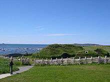
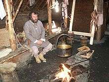
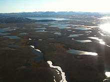
Newfoundland marine insurance agent and historian William A. Munn (1864–1939), after studying literary sources in Europe, suggested in his 1914 book Location of Helluland, Markland & Vinland from the Icelandic Sagas that the Vinland explorers "went ashore at Lancey [sic] Meadows, as it is called to-day".[34] In 1960 the remains of a small Norse encampment[7] were discovered by Helge and Anne Stine Ingstad at that exact spot, L'Anse aux Meadows in northern Newfoundland, and excavated during the 1960s and 1970s. It is most likely this was the main settlement of the sagas, a "gateway" for the Norse Greenlanders to the rich lands farther south. Many wooden objects were found at L'Anse aux Meadows, and radiocarbon dating confirms the site's occupation as being confined to a short period around 1000 CE. In addition, a number of small pieces of jasper, known to have been used in the Norse world as fire-strikers, were found in and around the different buildings. When these were analyzed and compared with samples from jasper sources around the north Atlantic area, it was found that two buildings contained only Icelandic jasper pieces, while another contained some from Greenland; also a single piece from the east coast of Newfoundland was found. These finds appear to confirm the saga claim that some of the Vinland exploration ships came from Iceland and that they ventured down the east coast of the new land.[35]
Based on such interpretations and archaeological evidence, it is now generally accepted that L'Anse aux Meadows was the main base of the Norse explorers,[36] but the southernmost limit of the Norse exploration remains a subject of intense speculation. Samuel Eliot Morison (1971) suggested the southern part of Newfoundland; Erik Wahlgren (1986) Miramichi Bay in New Brunswick; and Icelandic climate specialist Pall Bergthorsson (1997) proposed New York City.[37] The insistence in all the main historical sources that grapes were found in Vinland suggests that the explorers ventured at least to the south side of the St. Lawrence River, as Jacques Cartier did 500 years later, finding both wild vines and nut trees.[38]
Three butternuts were a further important find at L'Anse aux Meadows: another species which grows only as far north as the St. Lawrence.[9][39]
These travels explain as well how the vinviðir (wine wood) the Norse were cutting down in the sagas is actually referring to the vines of Vitis riparia, a species of wild grape that grows on trees. As the Norse were searching for lumber, a material that was needed in Greenland, they found trees covered with Vitis riparia south of L'Anse aux Meadows and called them vinviðir.[10]
L'Anse Aux Meadows was a small and short-lived encampment;[7] perhaps it was primarily used as timber-gathering forays and boat repair, rather than permanent settlements like Greenland.[40]
Life in Vinland
The main resources that the people of Vinland relied on were wheat, berries, wine and fish. However, the wheat in the Vinlandic context is sandwort and not traditional wheat, and the grapes mentioned are native North American grapes, because the European grape (vitis vinifera) and wheat (triticum) existing in the New World before the Viking arrival in the tenth century is highly unlikely.[41] Both the sagas reference a river and a lake that had an abundance of fish. The sagas specifically mention salmon, and note how the salmon that was encountered was larger than any salmon they had seen before. Before arriving to Vinland, the Norsemen imported their lumber from Norway while in Greenland and had occasional birch trees for firewood. Therefore, the timber they acquired in North America increased their supply of wood.[42]
Other possible Norse finds
An authentic late-11th-century Norwegian silver penny, with a hole for stringing on a necklace, was found in Maine. Its discovery by an amateur archaeologist in 1957 is controversial; questions have been raised whether it was planted as a hoax.[43] Numerous artifacts attributed to the Norse have been found in Canada, particularly on Baffin Island and in northern Labrador.[44][45]
Other claimed Norse artifacts in the area south of the St. Lawrence include a number of stones inscribed with runic letters. The Kensington Runestone was found in Minnesota, but is generally considered a hoax. The authenticity of the Spirit Pond runestones, recovered in Phippsburg, Maine, is also questioned. Other examples are the Heavener Runestone, the Shawnee Runestone, and the Vérendrye Runestone. The age and origin of these stones is debated, and so far none has been firmly dated or associated with clear evidence of a medieval Norse presence.[46] In general, script in the runic alphabet does not in itself guarantee a Viking age or medieval connection, as Dalecarlian runes have been suggested to have been used until the 20th century.
Point Rosee, on the southwest coast of Newfoundland, was thought to be the location of a possible Norse settlement. The site was discovered through satellite imagery in 2014 by Sarah Parcak.[47][48] In their November 8, 2017, report, which was submitted to the Provincial Archaeology Office in St. John's, Newfoundland,[49] Sarah Parcak and Gregory "Greg" Mumford wrote that they "found no evidence whatsoever for either a Norse presence or human activity at Point Rosee prior to the historic period"[50] and that "None of the team members, including the Norse specialists, deemed this area as having any traces of human activity."[51]
See also
- Antillia
- Great Ireland (Hvítramannaland)
- Norse colonization of the Americas
- Point Rosee
- Pre-Columbian trans-oceanic contact theories
- Vinland map
- Vinland the Good
- Vitis labrusca
Notes
- "L'Anse aux Meadows National Historic Site". UNESCO. UNESCO. Retrieved 21 June 2020.
- Laurence Marcellus Larson in Canute the Great: 995 (circ.)-1035 and the Rise of Danish Imperialism During the Viking Age, New York: Putnam, 1912 p. 17
- Elizabeth Janeway in The Vikings, New York, Random House, 1951 throughout
- Danver, Steven L. (2010). Popular Controversies in World History: Investigating History's Intriguing Questions. 4. ABC-CLIO. p. 2. ISBN 978-1-59884-078-0.
- William C. Wonders (2003). Canada's Changing North. McGill-Queen's Press - MQUP. pp. 28–29. ISBN 978-0-7735-7132-7.
- Sigurdsson, Gisli (2008). The Vinland Sagas. London: Penguin. p. xv. ISBN 978-0-140-44776-7. Retrieved 21 June 2020.
- "L'Anse aux Meadows". L'Anse aux Meadows National Historic Site of Canada. Parks Canada. 2018. Retrieved 2018-12-21.
Here [L'Anse aux Meadows] Norse expeditions sailed from Greenland, building a small encampment of timber-and-sod buildings …
- Ingstad, Helge; Ingstad, Anne Stine (2001). The Viking Discovery of America: The Excavation of a Norse Settlement in L'Anse aux Meadows, Newfoundland. Checkmark Books. ISBN 0-8160-4716-2.
- "Is L'Anse aux Meadows Vinland?". L'Anse aux Meadows National Historic Site of Canada. Parks Canada. 2003. Archived from the original on 2007-05-22. Retrieved 2010-04-20.
- Significance of the discovery of butternut shells at L'Anse aux Meadows: Birgitta Wallace, "The Norse in Newfoundland: L'Anse aux Meadows and Vinland", The New Early Modern Newfoundland: Part 2 (2003), Vol. 19, No. 1. "Many scholars have dismissed L’Anse aux Meadows as peripheral in the Vinland story (Kristjánsson 2005:39). I myself held that view for a long time. I am now contending that L’Anse aux Meadows is in fact the key to unlocking the Vinland sagas. Two factors crystallized this idea in my mind. One was my subsequent research into early French exploitation outposts in Acadia (Wallace 1999) and the nature of migration (Anthony 1990) [...] The second signal was the identification of butternut remains in the Norse stratum at L’Anse aux Meadows. Here was the smoking gun that linked the limited environment of northern Newfoundland with a lush environment in the Gulf of St. Lawrence, where wild grapes did indeed exist. The mythical Vinland had a basis in archaeological fact." Birgitta Wallace, "L’Anse aux Meadows, Leif Eriksson’s Home in Vinland", Norse Greenland: Selected Papers from the Hvalsey Conference 2008 Journal of the North Atlantic, 2009, 114-125.
- Praeterea unam adhuc insulam recitavit a multis in eo repertam occeano, quae dicitur Winland, eo quod ibi vites sponte nascantur, vinum optimum ferentes. Some manuscripts have the gloss id est terra vini. M. Adam Bremensis Lib. IV, Cap. XXXVIIII, ed. B. Schmeidler 1917, p. 275 Archived 2015-07-10 at the Wayback Machine.
- c.f. the alternative English name for blueberry is whinberry or winberry. Henley, Jon. Bilberries: the true taste of northern England The Guardian, 9 June 2008.
- "Professor Sven Söderberg om Vinland", Sydsvenska Dagbladet Snällposten, Nr. 295, 30 October 1910. "On a philological basis it can hardly be determined whether the first member is to be interpreted as "vine", as most have done, or as "pasture, meadow"." Sverre Marstrander, "Arkeologiske funn bekrefter sagaens Vinlandsberetninger", Forskningsnytt, XIX:3 (1974), 2-11.
- It remains a common place-name element in Scandinavia, e.g. in Bjørgvin and Granvin, also "possibly in a kenning for Sjaelland, viney, where we have no means of knowing exactly what it implies" (Haugen 1977). A cognate name also existed in Old English (Anglo-Saxon), in the name of the village Woolland in Dorset, England: this was written "Winlande" in the 1086 Domesday Book, and it is interpreted as "meadow land" or "pasture land".
- "Was Vinland in Newfoundland", Proceedings of the Eighth Viking Congress, Arhus. 24–31 August 1977, ed. Hans Bekker-Nielsen, Peter Foote, Olaf Olsen. Odense University Press. 1981.. See also Kirsten A. Seaver, Maps, Myths and Men. The story of the Vinland Map, Stanford University Press, p. 41.
- P. B. Taylor, "The Hønen runes: A survey", Neophilologus Volume 60, Issue 1 (January 1976), pp 1-7. See also: Text and translation of the copy Archived 2015-01-28 at the Wayback Machine Geirodden.com; C. Cavaleri (2008), "The Vínland Sagas as Propaganda for the Christian Church: Freydís and Gudríd as Paradigms for Eve and the Virgin Mary" Master's thesis, University of Oslo.
- Vinland and Ultima Thule. John Th. Honti. Modern Language Notes Vol. 54, No. 3 (Mar., 1939), pp. 159-172 Jstor.org
- Jónas Kristjánsson et al. (2012) Falling into Vínland. Acta Archeologica 83, pp. 145-177
- Jane Smiley, “The Sagas of the Greenlanders and The Saga of Eirik the Red” in The Sagas of the Icelanders (New York: Penguin, 2005), 672.
- based on translations by Keneva Kunz, with table of story element comparisons, in "The Sagas of Icelanders", London, Allen Lane (2000) ISBN 0-7139-9356-1
- "Where is Vinland?". www.canadianmysteries.ca.
- Adam of Bremen, Descriptio insularum Aquilonis chapters 37-38 (in Latin)
- Helge Ingstad and Anne Stine Ingstad, “Adam of Bremen: About the discovery of Vinland conflicting evidence,” in The Viking Discovery of America: The Excavation of a Norse Settlement in L’Anse Aux Meadows, Newfoundland (New York: Checkmark Books, 2001)105.
- Merrill, William Stetson. “The Vinland Problem through Four Centuries.” The Catholic Historical Review 21, no. 1 (April 1935):26.JSTOR.
- Livingston, Michael (March 2004). "More Vinland maps and texts". Journal of Medieval History. 30 (1): 25–44. doi:10.1016/j.jmedhist.2003.12.001.
- translations in: B.F. de Costa, Pre-Columbian Discovery of America by the Northmen Archived 2008-07-05 at the Wayback Machine, Albany NY, Munsell, 1890
- "Historia Norwegiae" (PDF).
- chronicle entries translated in A.M. Reeves et al. The Norse Discovery of America (1906) via saacred-texts.com
- McManis D. 1969. The Traditions of Vinland. Annals of the Association of American Geographers 59(4) DOI:10.1111/j.1467-8306.1969.tb01812.x
- Kaups M, Some Observations on Vinland, Annals of the Association of American Geographers, Volume 60, Issue 3, pages 603–609, September 1970. DOI: 10.1111/j.1467-8306.1970.tb00746.x
- Jørgensen, Dolly (2009-01-12). "A review of the book Isolated Islands in Medieval Nature, Culture and Mind". The Medieval Review. Archived from the original on 2013-07-30.
- "The Project Gutenberg eBook of Eirik The Red's Saga:, by The Rev. J. Sephton". www.gutenberg.org.
- R. Cleasby & G. Vigfusson An Icelandic-English Dictionary (1874) via the Germanic Lexicon Project
- Munn, William A. (1914). Location of Helluland, Markland, and Vinland from the Icelandic Sagas. St. John's, Newfoundland: Gazette Print. p. 11. Retrieved 18 April 2020.
- Where is Vinland: L'Anse aux Meadows at canadianmysteries.ca
- Regal, Brian (November–December 2019). "Everything Means Something in Viking". Skeptical Inquirer. Vol. 43 no. 6. Center for Inquiry. pp. 44–47.
- Gisli Sigurdsson, "The Quest for Vinland in Saga Scholarship", in William Fitzhugh & Elizabeth Ward (Eds.) Vikings: the North Atlantic Saga, Washington DC, Smithsonian Institution (2000) ISBN 1-56098-995-5
- Cartier, Jacques (1863). Voyage de J. Cartier au Canada.
- COSEWIC report on Juglans cinerea (butternut) in Canada
- Frakes, Jerold C., “Vikings, Vínland and the Discourse of Eurocentrism.” The Journal of English and Germanic Philology 100, no. 2 (April, 2001):197
- Frakes, Jerold C., “Vikings, Vínland and the Discourse of Eurocentrism.” The Journal of English and Germanic Philology 100, no. 2 (April, 2001): 175
- Hoidal, Oddvar K., “Norsemen and the North American Forests.” Journal of Forest History 24, no.4 (October, 1980): 201.
- Edmund S. Carpenter, "Norse Penny", New York (2003); See also the critical book review of Bruce Bourque’s "Twelve Thousand Years: American Indians in Maine", published in "American Anthropologist" 104 (2): 670-72, and Prins, Harald E.L., and McBride, Bunny, "Asticou's Island Domain: Wabanaki Peoples at Mount Desert Island 1500-2000." (National Park Service) nps.gov
- Pringle, Heather (19 Oct 2012). "Evidence of Viking Outpost Found in Canada". National Geographic News. National Geographic Society. Retrieved 2013-01-28.
- "Strangers, Partners, Neighbors? Helluland Archaeology Project: Recent Finds". Canadian Museum of History. Retrieved December 19, 2018.
- William W. Fitzhugh & Elizabeth I. Ward (Eds), "Vikings: The North Atlantic Saga", Washington DC, Smithsonian Books (2000) ISBN 1-56098-995-5
- Kean, Gary (April 2, 2016). "Update: Archaeologist thinks Codroy Valley may have once been visited by Vikings". The Western Star. Archived from the original on 2016-04-16. Retrieved 2019-01-07.
- Strauss, Mark (March 31, 2016). "Discovery Could Rewrite History of Vikings in New World". National Geographic.
- Parcak, Sarah; Mumford, Gregory (November 8, 2017). "Point Rosee, Codroy Valley, NL (ClBu-07) 2016 Test Excavations under Archaeological Investigation Permit #16.26" (PDF). geraldpennyassociates.com, 42 pages. Archived from the original (PDF) on June 20, 2018. Retrieved June 19, 2018.
[The 2015 and 2016 excavations] found no evidence whatsoever for either a Norse presence or human activity at Point Rosee prior to the historic period. […] None of the team members, including the Norse specialists, deemed this area [Point Rosee] as having any traces of human activity.
- McKenzie-Sutter, Holly (May 31, 2018). "No Viking presence in southern Newfoundland after all, American researcher finds". The Canadian Press. Archived from the original on 2018-06-18. Retrieved June 18, 2018.
An archaeological report presented to the provincial government says there are no signs of a Norse presence in the Point Rosee area in the Codroy Valley. The report on the archaeological work carried out in the area in 2015 and 2016 failed to turn up any signs of Norse occupation, with "no clear evidence" of human occupation before 1800.
- Bird, Lindsay (May 30, 2018). "Archeological quest for Codroy Valley Vikings comes up short - Report filed with province states no Norse activity found at dig site". CBC. Retrieved June 18, 2018.
An archeological team searching for a Norse settlement at Point Rosee in the Codroy Valley has come away empty-handed, according to a project report submitted to the province. […] Parcak and Mumford led digs at Point Rosee during the summers of 2015 and 2016, along the way attracting media attention from PBS to the New York Times […]
References
- Jones, Gwyn (1986). The Norse Atlantic Saga: Being the Norse Voyages of Discovery and Settlement to Iceland, Greenland, and North America. Oxford University Press. ISBN 0-19-285160-8.
- Sverrir Jakobsson, "Vínland and Wishful Thinking: Medieval and Modern Fantasies," Canadian Journal of History (2012) 47#3 pp 493–514.
External links
| Wikimedia Commons has media related to Vinland. |
- . Encyclopædia Britannica. 28 (11th ed.). 1911.
- Parks Canada - L'Anse aux Meadows National Historic Site of Canada
- Vikings: The north Atlantic saga; Searching for archeological evidence of Vikings in Labrador and Newfoundland - from The Smithsonian Institution's National Museum of Natural History
- The Vinland Mystery - a National Film Board of Canada documentary
- "Where is Vinland?", Great Unsolved Mysteries in Canadian History website
- Skálholt Map - in the Royal Library, Copenhagen, Denmark
- Full text of Eirik the Red's Saga