Vilaflor, Santa Cruz de Tenerife
Vilaflor is a municipality and a village in the south-central part of the island of Tenerife, one of the Canary Islands, and part of the Santa Cruz de Tenerife (province), Spain. Vilaflor, with an altitude of 1,400 m, is the highest village of Tenerife, situated south the Teide volcano. It is located 7 km north of San Miguel de Abona and 51 km southwest of the island's capital Santa Cruz de Tenerife. The population is 1,645 (2018)[3] and the area is 56.26 km².[1]
Vilaflor | |
|---|---|
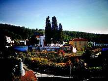
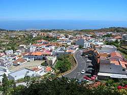 Vilaflor from above | |
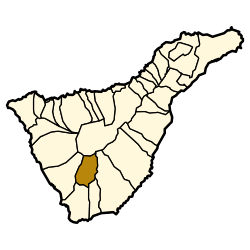 Municipal location in Tenerife | |
 Vilaflor Location in Province of Santa Cruz de Tenerife  Vilaflor Vilaflor (Canary Islands)  Vilaflor Vilaflor (Spain, Canary Islands) | |
| Coordinates: 28°9′30″N 16°38′10″W | |
| Country | |
| Autonomous Region | Canary Islands |
| Province | Santa Cruz de Tenerife |
| Island | Tenerife |
| Area | |
| • Total | 56.26 km2 (21.72 sq mi) |
| Population (2018)[2] | |
| • Total | 1,645 |
| • Density | 29/km2 (76/sq mi) |
| Time zone | UTC+0 (GMT) |
| Climate | Csb |
| Website | www.vilaflordechasna.es |
Sights
- Paisaje Lunar, a geological curiosity created by erosion
- El Piño Gordo pine tree.
- the mineral springs of Fuente Alta, which can be found at 1400 meters above sea level in a protected nature reserve. The bottled water company Fuentealta derives from this mineral spring.
- Sanctuary of the Santo Hermano Pedro, a church built in honor of Saint Peter of Saint Joseph Betancur (Santo Hermano Pedro).
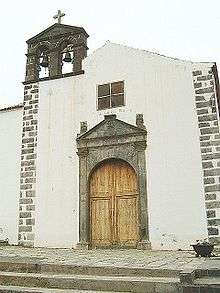
Church of San Pedro
History
Vilaflor
The town of Vilaflor de Chasna was founded in the sixteenth century. Saint Peter of Saint Joseph Betancur was born in Vilaflor in 1626.
Climate
| Climate data for Vilaflor 1378m (Temperatures:1983-1995; Precipitation:1945-1997) | |||||||||||||
|---|---|---|---|---|---|---|---|---|---|---|---|---|---|
| Month | Jan | Feb | Mar | Apr | May | Jun | Jul | Aug | Sep | Oct | Nov | Dec | Year |
| Average high °C (°F) | 13.5 (56.3) |
14.4 (57.9) |
16.0 (60.8) |
16.1 (61.0) |
18.3 (64.9) |
21.2 (70.2) |
27.4 (81.3) |
27.9 (82.2) |
23.5 (74.3) |
18.7 (65.7) |
16.0 (60.8) |
14.5 (58.1) |
19.0 (66.2) |
| Daily mean °C (°F) | 9.4 (48.9) |
10.2 (50.4) |
11.7 (53.1) |
11.9 (53.4) |
13.8 (56.8) |
16.7 (62.1) |
22.7 (72.9) |
23.0 (73.4) |
19.2 (66.6) |
14.4 (57.9) |
11.4 (52.5) |
10.0 (50.0) |
14.7 (58.5) |
| Average low °C (°F) | 5.4 (41.7) |
6.0 (42.8) |
7.3 (45.1) |
7.2 (45.0) |
9.5 (49.1) |
12.2 (54.0) |
18.0 (64.4) |
18.5 (65.3) |
14.8 (58.6) |
10.4 (50.7) |
8.2 (46.8) |
7.0 (44.6) |
10.2 (50.4) |
| Average precipitation mm (inches) | 49.4 (1.94) |
51.2 (2.02) |
34.1 (1.34) |
24.4 (0.96) |
2.7 (0.11) |
0.4 (0.02) |
0.0 (0.0) |
0.8 (0.03) |
7.5 (0.30) |
33.8 (1.33) |
70.6 (2.78) |
56.2 (2.21) |
366.1 (14.41) |
| Average rainy days | 5.0 | 5.0 | 5.0 | 4.0 | 3.0 | 2.0 | 1.0 | 1.0 | 3.0 | 5.0 | 6.0 | 6.0 | 46 |
| Mean daily sunshine hours | 6.0 | 7.0 | 7.0 | 8.0 | 9.0 | 9.0 | 10.0 | 9.0 | 8.0 | 7.0 | 6.0 | 6.0 | 7.7 |
| Percent possible sunshine | 55 | 64 | 58 | 62 | 64 | 64 | 71 | 69 | 67 | 64 | 55 | 60 | 63 |
| Source 1: Gobierno de Canarias [4] | |||||||||||||
| Source 2: Weather Atlas (rainy days and sunshine data)[5] | |||||||||||||
| Climate data for Vilaflor | |||||||||||||
|---|---|---|---|---|---|---|---|---|---|---|---|---|---|
| Month | Jan | Feb | Mar | Apr | May | Jun | Jul | Aug | Sep | Oct | Nov | Dec | Year |
| Mean daily daylight hours | 11.0 | 11.0 | 12.0 | 13.0 | 14.0 | 14.0 | 14.0 | 13.0 | 12.0 | 11.0 | 11.0 | 10.0 | 12.2 |
| Average Ultraviolet index | 4 | 6 | 8 | 9 | 10 | 11 | 11 | 11 | 9 | 7 | 5 | 4 | 7.9 |
| Source: Weather Atlas[5] | |||||||||||||
Historical population
| Year | Population |
|---|---|
| 2003 | 1,798 |
| 2013 | 1,804 |
References
- Instituto Canario de Estadística, area
- Municipal Register of Spain 2018. National Statistics Institute.
- Instituto Canario de Estadística Archived April 19, 2014, at the Wayback Machine, population
- "Documento informativo del Plan Especial del paisaje protegido de Ifonche" (PDF). Archived from the original (PDF) on 2016-03-04.
- "Vilaflor, Spain - Climate data". Weather Atlas. Retrieved 16 March 2017.
External links
- Official website


Places adjacent to Vilaflor, Santa Cruz de Tenerife | |
|---|---|
Municipalities in the province of Santa Cruz de Tenerife | ||
|---|---|---|
| Tenerife |
| |
| La Palma |
| |
| La Gomera |
| |
| El Hierro |
| |
This article is issued from Wikipedia. The text is licensed under Creative Commons - Attribution - Sharealike. Additional terms may apply for the media files.