Venango Path
Venango Path was a Native American trail between the Forks of the Ohio (present day Pittsburgh) and Presque Isle, Pennsylvania, United States of America.[1] The trail was named after the Native American village of Venango where French Creek flows into the Allegheny River. The village is now the site of the small city of Franklin, Pennsylvania.
Washington's mission to Fort Le Boeuf
George Washington and Christopher Gist travelled along the trail during December 1753 to deliver a message to the French near Venango village. Due to inclement weather, Washington and Gist left the trail at the Forks of the Ohio, and found shelter in the Indian village of Logstown (near present-day Ambridge, Pennsylvania).[2] Washington and his men left the village a few days later and proceeded northeast through what is now Cranberry to Murdering Town along the Connoquenessing Creek.[3]
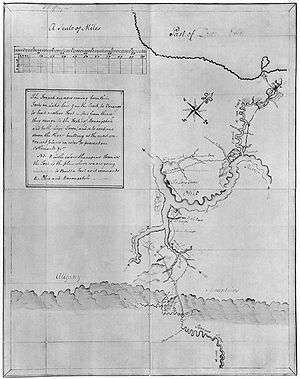
On their return from Fort Le Boeuf, Washington and Gist left the Venango Path at Murdering Town which was located at or near present-day Evans City, and Harmony, Pennsylvania on what Gist termed the "southeast fork of Beaver creek"[4] (present-day Connoquenessing Creek).[5] A Native at the village agreed to guide them down a different trail to the Forks. After marching several miles to the northeast of the original path, the Native turned on Washington and Gist, and fired a shot from his gun.[6][7] The men escaped harm, but Gist wanted the captured Native executed.[6][8] However, Washington ordered his attempted assassin released.[6][9] After the attempted assassination, the two men traveled "across country" through the forest with the use of a compass to "the head of Piney creek."[6] From there, they travelled down-stream to the Allegheny River. After spending the night on a small island (Herr's Island, later renamed Washington's Landing), they moved a short distance down the river, just above the Native village of Shannopin's Town.[10] From there, they continued their trek back to Williamsburg, Virginia which they arrived at on January 16, 1754.
French and Indian War
During the early French and Indian War years, when the French occupied western Pennsylvania, the trail became a military road connecting a series of French Forts from Lake Erie to Pittsburgh. These forts included Fort Presque Isle located on Lake Erie, Fort Le Boeuf (present day Waterford), Fort Machault at Venango (present day Franklin) and Fort Duquesne at present day Pittsburgh.
When the British drove the French from Western Pennsylvania (1758) the French burned and abandoned all four forts. The British promptly rebuilt all four again during 1759, changing the name Fort Machault to Fort Venango, and Fort Duquesne to Fort Pitt. Thus the British continued to use the Venango Path as a military road.
During Pontiac's War four years later (1763), hostile Natives burned Forts Presque Isle, Le Boeuf and Venango. After the Battle of Bushy Run, where a British army defeated several hostile tribes, the Natives relocated into Ohio and westward. The Venango Path was thereafter no longer used as a Native American trail. After hostilities ceased in western Pennsylvania, there was no further major military use of the trail.
Notes
- The French and Indian War in Pennsylvania 1753-1763, pp. 5.
- The French and Indian War in Pennsylvania 1753-1763, pp. 6.
- Journals of Washington and Gist, pp. 50.
- Journals of Washington and Gist, pp. 35.
- Journals of Washington and Gist, pp. 53.
- Journals of Washington and Gist, pp. 36.
- Michael and Jana Novak, pp. 50.
- Michael and Jana Novak, pp. 50-51.
- Michael and Jana Novak, pp. 51.
- Journals of Washington and Gist, pp. 37.
References
- The French and Indian War in Pennsylvania 1753-1763, Commonwealth of Pennsylvania., 1996, ISBN 0-89271-057-8.
- The Journals of George Washington and Christopher Gist: Mission to Fort Le Boeuf 1753-1754, Slippery Rock University, 2003.
- Novak, Michael, and Jana Novak, Washington's God, Basic Books, 2006, ISBN 0-465-05126-X.