VanLeer, Tennessee
Vanleer is a town in Dickson County, Tennessee. The population was 310 at the 2000 census and 395 at the 2010 census. The town is named for Anthony Wayne Van Leer, onetime operator of the iron works in nearby Cumberland Furnace and member of the historical iron family from Pennsylvania.
Vanleer, Tennessee | |
|---|---|
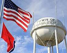 Flag | |
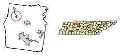 Location of Vanleer in Dickson County, Tennessee. | |
| Coordinates: 36°14′15″N 87°26′41″W | |
| Country | United States |
| State | Tennessee |
| County | Dickson |
| Incorporated | 1915[1] |
| Named for | Anthony Van Leer, early settler[1] |
| Area | |
| • Total | 0.70 sq mi (1.82 km2) |
| • Land | 0.70 sq mi (1.82 km2) |
| • Water | 0.00 sq mi (0.00 km2) |
| Elevation | 843 ft (257 m) |
| Population (2010) | |
| • Total | 395 |
| • Estimate (2018)[3] | 415 |
| • Density | 591.17/sq mi (228.24/km2) |
| Time zone | UTC-6 (Central (CST)) |
| • Summer (DST) | UTC-5 (CDT) |
| ZIP code | 37181 |
| Area code(s) | 615 |
| FIPS code | 47-76860[4] |
| GNIS feature ID | 1304296[5] |
Geography
Vanleer is located at 36°14′15″N 87°26′41″W (36.237444, -87.444807).[6]
According to the United States Census Bureau, the town has a total area of 0.6 square miles (1.6 km2), all land.
Demographics
| Historical population | |||
|---|---|---|---|
| Census | Pop. | %± | |
| 1920 | 180 | — | |
| 1930 | 243 | 35.0% | |
| 1940 | 206 | −15.2% | |
| 1950 | 243 | 18.0% | |
| 1960 | 234 | −3.7% | |
| 1970 | 320 | 36.8% | |
| 1980 | 401 | 25.3% | |
| 1990 | 369 | −8.0% | |
| 2000 | 310 | −16.0% | |
| 2010 | 395 | 27.4% | |
| Est. 2018 | 415 | [3] | 5.1% |
| Sources:[7][8] | |||
As of the census[4] of 2000, there were 310 people, 124 households, and 90 families residing in the town. The population density was 500.9 people per square mile (193.1/km²). There were 141 housing units at an average density of 227.8 per square mile (87.8/km²). The racial makeup of the town was 94.52% White, 0.65% African American, and 4.84% from two or more races.
There were 124 households out of which 28.2% had children under the age of 18 living with them, 56.5% were married couples living together, 12.1% had a female householder with no husband present, and 27.4% were non-families. 25.8% of all households were made up of individuals and 12.9% had someone living alone who was 65 years of age or older. The average household size was 2.50 and the average family size was 2.88.
In the town, the population was spread out with 21.0% under the age of 18, 7.7% from 18 to 24, 27.1% from 25 to 44, 24.8% from 45 to 64, and 19.4% who were 65 years of age or older. The median age was 40 years. For every 100 females, there were 95.0 males. For every 100 females age 18 and over, there were 99.2 males.
The median income for a household in the town was $26,607, and the median income for a family was $30,500. Males had a median income of $25,938 versus $26,250 for females. The per capita income for the town was $20,572. About 28.7% of families and 26.3% of the population were below the poverty line, including 39.2% of those under age 18 and 33.3% of those age 65 or over.
Education
- Vanleer Elementary School, a public school operated by the Dickson County Public Schools, grades 1 – 5
- A former public high school (through grade 10) operated into the 1950s
Notable people
- Paul Hinson, baseball player
- Mary Magdalena Lewis Tate, Pentecostal minister
- Kala Pleasant, actress (appeared on WWE SmackDown in 2016)
- Luke Perry, actor (made popular in Beverly Hills, 90210)[9]
Notable landmarks
- Faith Baptist Church, the site of the original Vanleer Elementary School.
- Leatherwood Mud Drags, recreational
- Morgans Market, catfish dinners every Friday and Saturday night
- Ruskin Cave, host of Camp Renaissance, sponsored by Dickson County's Jackson Foundation
- Dollar General, Vanleer's only operational store as of 2016
References
- "A Brief History of Vanleer," Dickson County Historical and Genealogical Society website, originally published in Heritage Book of Dickson County, 1803-2006. Retrieved: 28 February 2013.
- "2018 U.S. Gazetteer Files". United States Census Bureau. Retrieved February 23, 2020.
- "Population and Housing Unit Estimates". United States Census Bureau. June 27, 2019. Retrieved June 4, 2019.
- "U.S. Census website". United States Census Bureau. Retrieved 2008-01-31.
- "US Board on Geographic Names". United States Geological Survey. 2007-10-25. Retrieved 2008-01-31.
- "US Gazetteer files: 2010, 2000, and 1990". United States Census Bureau. 2011-02-12. Retrieved 2011-04-23.
- "Census of Population and Housing: Decennial Censuses". United States Census Bureau. Retrieved 2012-03-04.
- "Incorporated Places and Minor Civil Divisions Datasets: Subcounty Resident Population Estimates: April 1, 2010 to July 1, 2012". Population Estimates. U.S. Census Bureau. Archived from the original on 17 June 2013. Retrieved 11 December 2013.
- Barnes, Dustin. "Luke Perry buried near Tennessee home, according to death certificate". The Tennessean. Retrieved 14 March 2019.
Municipalities and communities of Dickson County, Tennessee, United States | ||
|---|---|---|
| City | ||
| Towns |
| |
| Unincorporated communities | ||