Ust-Olenyok
Ust-Olenyok (Russian: Усть-Оленёк; Yakut: Уус Өлөөн) is a rural locality (a selo), the only inhabited locality, and the administrative center of Ystannakhsky Rural Okrug of Bulunsky District in the Sakha Republic, Russia, located 365 kilometers (227 mi) from Tiksi, the administrative center of the district.[1] Its population as of the 2010 Census was 27,[2] down from 52 recorded during the 2002 Census.[1]
Ust-Olenyok Усть-Оленек | |
|---|---|
Location of Ust-Olenyok 
| |
 Ust-Olenyok Location of Ust-Olenyok  Ust-Olenyok Ust-Olenyok (Sakha Republic) | |
| Coordinates: 72°59′N 119°49′E | |
| Country | Russia |
| Federal subject | Sakha Republic[1] |
| Administrative district | Bulunsky District[1] |
| Rural okrug | Ystannakhsky Rural Okrug[1] |
| Population | |
| • Total | 27 |
| • Capital of | Ystannakhsky Rural Okrug[1] |
| • Municipal district | Bulunsky Municipal District[3] |
| • Rural settlement | Tyumetinsky Rural Settlement[3] |
| Time zone | UTC+9 (MSK+6 |
| Postal code(s)[5] | 678415 |
| OKTMO ID | 98612445111 |
History
The first settlement was a wintering hut built in 1633 near the modern village. It served as the administrative center of the desolate area and it was used by Arctic expeditions in different occasions in history.[6]
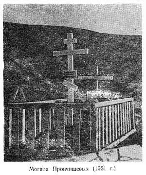 1921 picture of the grave of Vasili and Tatiana Pronchishchev in Ust-Olenyok. The tomb was moved after the bodies were exhumed in 1999. |
Climate
Ust-Olenyok has a tundra climate (ET).
| Climate data for Ust-Olenyok | |||||||||||||
|---|---|---|---|---|---|---|---|---|---|---|---|---|---|
| Month | Jan | Feb | Mar | Apr | May | Jun | Jul | Aug | Sep | Oct | Nov | Dec | Year |
| Record high °C (°F) | −12.8 (9.0) |
−10.4 (13.3) |
8.0 (46.4) |
15.0 (59.0) |
12.0 (53.6) |
27.2 (81.0) |
31.1 (88.0) |
26.2 (79.2) |
25.0 (77.0) |
14.5 (58.1) |
1.0 (33.8) |
−6.3 (20.7) |
31.1 (88.0) |
| Average high °C (°F) | −30.6 (−23.1) |
−29.6 (−21.3) |
−24.6 (−12.3) |
−16.2 (2.8) |
−5.4 (22.3) |
5.5 (41.9) |
12.3 (54.1) |
10.0 (50.0) |
2.7 (36.9) |
−10.3 (13.5) |
−23.3 (−9.9) |
−28.0 (−18.4) |
−12.6 (9.3) |
| Daily mean °C (°F) | −33.4 (−28.1) |
−32.4 (−26.3) |
−28.1 (−18.6) |
−20.2 (−4.4) |
−8.3 (17.1) |
2.5 (36.5) |
8.4 (47.1) |
6.7 (44.1) |
0.5 (32.9) |
−13.0 (8.6) |
−26.4 (−15.5) |
−30.9 (−23.6) |
−15.7 (3.7) |
| Average low °C (°F) | −36.8 (−34.2) |
−35.9 (−32.6) |
−32.2 (−26.0) |
−25.3 (−13.5) |
−12.5 (9.5) |
−0.9 (30.4) |
4.1 (39.4) |
3.4 (38.1) |
−2.0 (28.4) |
−16.3 (2.7) |
−29.7 (−21.5) |
−34.3 (−29.7) |
−19.4 (−2.9) |
| Record low °C (°F) | −50.0 (−58.0) |
−52.0 (−61.6) |
−46.1 (−51.0) |
−40.3 (−40.5) |
−28.9 (−20.0) |
−25.0 (−13.0) |
−2.2 (28.0) |
−6.1 (21.0) |
−12.2 (10.0) |
−40.0 (−40.0) |
−46.2 (−51.2) |
−49.1 (−56.4) |
−52.0 (−61.6) |
| Average precipitation mm (inches) | 7.2 (0.28) |
7.7 (0.30) |
12.6 (0.50) |
14.2 (0.56) |
14.3 (0.56) |
26.3 (1.04) |
21.2 (0.83) |
36.5 (1.44) |
22.1 (0.87) |
34.1 (1.34) |
16.5 (0.65) |
10.7 (0.42) |
223.4 (8.80) |
| Source: [7] | |||||||||||||
References
Notes
- Registry of the Administrative-Territorial Divisions of the Sakha Republic
- Sakha Republic Territorial Branch of the Federal State Statistics Service. Results of the 2010 All-Russian Census. Численность населения по районам, городским и сельским населённым пунктам (Population Counts by Districts, Urban and Rural Inhabited Localities) (in Russian)
- Law #173-Z 353-III
- "Об исчислении времени". Официальный интернет-портал правовой информации (in Russian). June 3, 2011. Retrieved January 19, 2019.
- Почта России. Информационно-вычислительный центр ОАСУ РПО. (Russian Post). Поиск объектов почтовой связи (Postal Objects Search) (in Russian)
- Olenyok wintering hut, a historical monument of Eastern Siberia . Bulletin of Tomsk State University. No. 3 (23), 2013
- "Weather Averages for Ust-Olenyok (1955-1991)". climatebase.ru. Retrieved December 18, 2014.
Sources
- Official website of the Sakha Republic. Registry of the Administrative-Territorial Divisions of the Sakha Republic. Bulunsky District. (in Russian)
- Государственное Собрание (Ил Тумэн) Республики Саха (Якутия). Закон №173-З №353-III от 30 ноября 2004 г. «Об установлении границ и о наделении статусом городского и сельского поселений муниципальных образований Республики Саха (Якутия)», в ред. Закона №1058-З №1007-IV от 25 апреля 2012 г. «О внесении изменений в Закон Республики Саха (Якутия) "Об установлении границ и о наделении статусом городского и сельского поселений муниципальных образований Республики Саха (Якутия)"». Вступил в силу со дня официального опубликования. Опубликован: "Якутия", №245, 31 декабря 2004 г. (State Assembly (Il Tumen) of the Sakha (Yakutia) Republic. Law #173-Z No. 353-III of November 30, 2004 On Establishing the Borders and on Granting the Urban and Rural Settlement Status to the Municipal Formations of the Sakha (Yakutia) Republic, as amended by the Law #1058-Z No. 1007-IV of April 25, 2012 On Amending the Law of the Sakha (Yakutia) Republic "On Establishing the Borders and on Granting the Urban and Rural Settlement Status to the Municipal Formations of the Sakha (Yakutia) Republic". Effective as of the day of the official publication.).
This article is issued from Wikipedia. The text is licensed under Creative Commons - Attribution - Sharealike. Additional terms may apply for the media files.