Upper Mississippi water resource region
The Upper Mississippi water resource region is one of 21 major geographic areas, or regions, in the first level of classification used by the United States Geological Survey to divide and sub-divide the United States into successively smaller hydrologic units. These geographic areas contain either the drainage area of a major river, or the combined drainage areas of a series of rivers.[1][2]
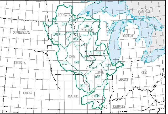
The Upper Mississippi region, which is listed with a 2-digit hydrologic unit code (HUC) of 07, has an approximate size of 189,968 square miles (492,010 square kilometers), and consists of 14 subregions, which are listed with the 4-digit HUCs 0701 through 0711.
This region includes the drainage of the Mississippi River Basin above the confluence with the Ohio River, excluding the Missouri River Basin. Includes parts of Illinois, Indiana, Iowa, Michigan, Minnesota, Missouri, South Dakota, and Wisconsin.[3]
List of water resource subregions
| Subregion HUC[4] | Subregion Name[4] | Subregion Description[3] | Subregion Location[4] | Subregion Size (mi2)[4] | Subregion Map |
|---|---|---|---|---|---|
| 0701 | Mississippi Headwaters Subregion | The Mississippi River Basin above the confluence with the St. Croix River Basin, excluding the Minnesota River Basin. | Located in Minnesota. | 20,200 sq mi (52,000 km2) |  HUC0701 |
| 0702 | Minnesota Subregion | The Minnesota River Basin. | Located in Iowa, Minnesota, and South Dakota. | 16,800 sq mi (44,000 km2) |  HUC0702 |
| 0703 | St. Croix Subregion | The St. Croix River Basin. | Located in Minnesota and Wisconsin. | 7,750 sq mi (20,100 km2) |  HUC0703 |
| 0704 | Upper Mississippi–Black–Root Subregion | The Mississippi River Basin below the confluence with the St. Croix River Basin to and including the Root River Basin west of the Mississippi River and the La Crosse River Basin east of the Mississippi River, excluding the Chippewa River Basin. | Located in Iowa, Minnesota, and Wisconsin. | 10,700 sq mi (28,000 km2) |  HUC0704 |
| 0705 | Chippewa Subregion | The Chippewa River Basin. | Located in Michigan and Wisconsin. | 9,570 sq mi (24,800 km2) |  HUC0705 |
| 0706 | Upper Mississippi–Maquoketa–Plum Subregion | The Mississippi River Basin below the Root River Basin west of the Mississippi River and the La Crosse River Basin east of the Mississippi River to Lock and Dam 13, excluding the Wisconsin River Basin. | Located in Illinois, Iowa, Minnesota, and Wisconsin. | 8,610 sq mi (22,300 km2) |  HUC0706 |
| 0707 | Wisconsin Subregion | The Wisconsin River Basin. | Located in Michigan and Wisconsin. | 11,900 sq mi (31,000 km2) |  HUC0707 |
| 0708 | Upper Mississippi–Iowa–Skunk–Wapsipinicon Subregion | Mississippi River Basin below Lock and Dam 13 to the confluence with the Des Moines River Basin, excluding the Rock River Basin. | Located in Illinois, Iowa, and Michigan. | 22,800 sq mi (59,000 km2) |  HUC0708 |
| 0709 | Rock Subregion | The Rock River Basin. | Located in Illinois and Wisconsin. | 10,900 sq mi (28,000 km2) |  HUC0709 |
| 0710 | Des Moines Subregion | The Des Moines River Basin. | Located in Iowa, Minnesota, and Missouri. | 14,400 sq mi (37,000 km2) |  HUC0710 |
| 0711 | Upper Mississippi–Salt Subregion | The Mississippi River Basin below the confluence with the Des Moines River Basin to the confluence with the Missouri River Basin, excluding the Illinois River Basin. | Located in Illinois, Iowa, and Missouri. | 9,970 sq mi (25,800 km2) |  HUC0711 |
| 0712 | Upper Illinois Subregion | The Illinois River Basin above the confluence of and including the Fox River Basin. | Located in Illinois, Indiana, Michigan, and Wisconsin. | 10,900 sq mi (28,000 km2) |  HUC0712 |
| 0713 | Lower Illinois Subregion | The Illinois River Basin below the confluence of the Fox River Basin. | Located in Illinois. | 17,700 sq mi (46,000 km2) |  HUC0713 |
| 0714 | Upper Mississippi–Kaskaskia–Meramec Subregion | The Mississippi River Basin below the confluence with and excluding the Missouri River Basin to the confluence with the Ohio River. | Located in Illinois and Missouri. | 11,200 sq mi (29,000 km2) |  HUC0714 |
See also
- List of rivers in the United States
- Water resource region
References
- "Science in Your Watershed - Locate Your Watershed". USGS. Retrieved 2016-10-12.

- "Hydrologic Unit Maps". USGS. Retrieved 2016-10-12.
- "Boundary Descriptions and Names of Regions, Subregions, Accounting Units and Cataloging Units". USGS. Retrieved 2016-10-12.
- McManamay RA, Bevelhimer MS, Kao SC, Yaxing W, Martinez-Gonzalez M, Samu N (2013). "National Hydropower Asset Assessment Environmental Attribution". USGS-Oak Ridge National Laboratory. Retrieved 2016-10-12.