Unakoti
The kokborok name of Unakoti is Subrai Khung as claimed by Jamatia Hoda; Unakoti hill literally means one less a koti in Bengali, hosts an ancient Shaivite place of worship with huge rock reliefs celebrating Shiva. It is the prime tourist spot of Unakoti District, Tripura in the Kailashahar Subdivision in the North-eastern Indian state of Tripura.[1] It is Shiva pilgrimage and dates back to 7th – 9th centuries if not earlier. In those time the Pala dynasty ruled over the Bengal. Tripura region was a part of mainland in Bengal under Samatat. Historians said (Nihar Ranjan Ray, Rakhaldas Bondopadhaya) the kingdom of Tripura was also a center of East Bengal and Samatat. The Tripura kingdom started to rule over the region in the 14-th century.
| Unakoti | |
|---|---|
 The rock wall | |
| Religion | |
| Affiliation | Hinduism |
| District | Unakoti |
| Location | |
| Location | Kailasahar |
| State | Tripura |
| Country | India |
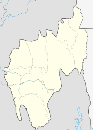 Location in Tripura  Unakoti (India) | |
| Geographic coordinates | 24°19′N 92°4′E |
| Architecture | |
| Completed | 600–700 CE |
Iconography
 Shiva with the waters of Ganga flowing from his locks.
 Close up of the sculpture of Shiva.
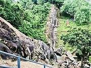 A wall of stone with reliefs.
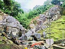
The images found at Unakoti are of two types: namely rock-carved figures and stone images. Among the rock-cut carvings, the central Shiva head and gigantic Ganesha figures deserve special mention. The central Shiva head known as Unakotiswara Kal Bhairava is about 30 feet high including an embroidered head-dress which itself is 10 feet high. On each side of the head-dress of the central Shiva, there are two full-size female figures - one of Durga standing on a lion and another female figure on the other side. In addition, three enormous images of Nandi Bull are found half-buried in the ground. There are various other stone as well as rock-cut images at Unakoti.
Festival
Every year a big fair popularly known as Ashokastami Mela is held in the month of April. The festival is visited by thousands of pilgrims. Another smaller festival takes place in January.
Location
Unakoti lies 178 km to the northeast from Agartala which has the closest airport, 8 km to the east from Kailashahar, district headquarters of Unakoti district, 148 km to the south-east from Silchar. The nearest railway station is 19.6 km away at Dharmanagar railway station on the Lumding–Sabroom section. From Dharmanagar railway station it takes about 30–40 minutes by car. Travelling from capital town Agartala has become much easier nowadays. The morning train from Agartala reaches Dharmanagar before 10 am. The afternoon train from Dharmanagar reaches Agartala by 8 PM.
Preservation
The site has suffered centuries of neglect causing degradation and loss of considerable scale to the rock art. Since its adoption by the ASI (Archaeological Survey of India) as a heritage site, the situation has slightly improved, though a lot of work including substantial excavation remains to be undertaken. The government of India has approached to UNESCO to declare it as a World Heritage Site.[2] The Centre has recently granted Rs 12 crore to the state for developing the area, 178 km from here, as a major tourist destination.[3]
References
- "TRIPURAINFOWAY: Tripura's Latest News, Views & IT Portal". www.tripurainfoway.com.
- "A Magic Number: Into the lost hill of Unakoti, Tripura". 27 March 2016.