Umgeni River
The Umgeni River or Mgeni River (Zulu: uMngeni), is a river in KwaZulu-Natal, South Africa. It rises in the "Dargle" in the KZN midlands, and its mouth is at Durban, some distance north of Durban's natural harbour. The name is taken to mean the river of entrance in Zulu, though other meanings have been proposed.[1][2]
| Umgeni River uMngeni (in Zulu) | |
|---|---|
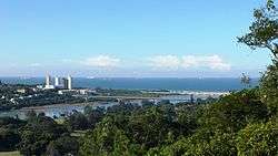 The Umgeni River's Blue Lagoon at Durban North | |
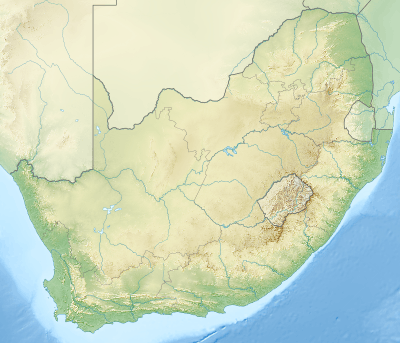 Location of the Umgeni River mouth | |
| Location | |
| Country | South Africa |
| Region | KwaZulu-Natal |
| Physical characteristics | |
| Source | Drakensberg |
| ⁃ elevation | 1,825 m (5,988 ft) |
| Mouth | Indian Ocean |
⁃ location | Durban, South Africa |
⁃ coordinates | 29°48′36″S 31°02′08″E |
⁃ elevation | 0 m (0 ft) |
| Length | 232 km (144 mi) |
| Basin size | 4,432 km2 (1,711 sq mi) |
| Basin features | |
| Tributaries | |
| ⁃ left | Msunduzi River |
The river is approximately 232 kilometres (144 mi) long with a catchment area of 4,432 square kilometres (1,711 sq mi). The Howick Falls are some famous waterfalls on the Mngeni.
Tributaries
A noteworthy tributary is the Msunduzi River, which joins it between Nagle and Inanda dams. Higher up its course, the Msunduzi (or 'Dusi' for short) passes through the KwaZulu-Natal capital Pietermaritzburg. A famous downriver race, the Dusi Canoe Marathon takes place between the capital and Durban, attracting thousands of canoeists for the three-day event held in January every year.
A small tributary that has an impact exceeding its size and length is the Lions River which joins the Umgeni about 4 kilometers upstream of Midmar Dam (near Lidgetton). Its significance lies in the fact that it is a part of a water transfer scheme between the Mooi River (Spring Grove Dam) and the Umgeni.
A smaller tributary close to its mouth is the 26-kilometre-long (16 mi) Palmiet River, which should not be confused with the Palmiet River in the Western Cape.[3]
Dams
Presently the Umgeni is part of the Mvoti to Umzimkulu Water Management Area.[4] There are four large dams in its catchment basin:
Ecology
The Scaly Yellowfish (Labeobarbus natalensis) is a fish found in the Umgeni River System as well as in the Umzimkhulu, Thukela, Umkhomazi and the Umfolozi. It is a common endemic species in KwaZulu-Natal Province and it lives in different habitats between the Drakensberg foothills and the coastal lowlands.[5][6]
History
It is assumed that Vasco da Gama replenished his fleet's water supply at the Umgeni mouth on Christmas Day, 1497, and so named the region Natal, Portuguese for Christmas. The river then acquired the name "River of Natal".
130 years later the Umgeni was crossed by Nathaniel Isaacs on his way to visit Shaka.[1]
See also
- Umgeni River Bird Park
- List of rivers of South Africa
- List of reservoirs and dams in South Africa
References
- du Plessis, E.J. (1973). Suid-Afrikaanse berg- en riviername. Tafelberg-uitgewers, Cape Town. pp. 277, 278. ISBN 0-624-00273-X.
- Raper, P.E. (2004). South African Place Names. Jonathan Ball, Jhb & Cape Town. p. 245. ISBN 1-86842-190-2.
- Palmiet Nature Reserve Flooding
- Mvoti to Umzimkulu WMA 11
- "Technical Report on the State of Yellowfishes in South Africa 2007" (PDF). Archived from the original (PDF) on 2017-06-29. Retrieved 2012-03-29.
- Agunbiade, Foluso O.; Moodley, Brenda (2014-07-16). "Pharmaceuticals as emerging organic contaminants in Umgeni River water system, KwaZulu-Natal, South Africa". Environmental Monitoring and Assessment. 186 (11): 7273–7291. doi:10.1007/s10661-014-3926-z. ISSN 0167-6369.
- Peters, Janice (1973). Proceedings of the first International Conference on Ephomeroptera. Brill Archive. p. 90. ISBN 978-90-04-03590-4.
External links
