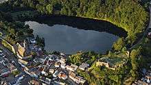
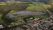
Ulmener Maar
The Ulmener Maar is a maar in the Eifel mountains of Germany in the immediate vicinity of the town of Ulmen in the state of Rhineland-Palatinate. The lake is up to 37 metres deep and is surrounded by an embankment of tuff with an average height of 20 metres, which was formed from the erupted material of the former volcano. By the southern edge of the embankment are the ruins of a knight's castle, Ulmen Castle dating to the 11th century.
| Ulmener Maar | |
|---|---|
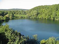 View looking north from the castle ruins of the upper ward | |
 Ulmener Maar | |
| Coordinates | 50°12′36″N 6°58′59″E |
| Primary inflows | Römerstollen (from Jungferweiher), Ulmener Bach (manmade, since 1875) |
| Primary outflows | no egress |
| Max. length | 0.51 km (0.32 mi) |
| Max. width | 0.25 km (0.16 mi) |
| Max. depth | 37 m (121 ft) |
| Shore length1 | 0.9 km (0.56 mi) |
| Surface elevation | 440 m (1,440 ft) |
| Settlements | Ulmen |
| 1 Shore length is not a well-defined measure. | |
See also
- List of lakes in Germany
- List of volcanoes in Germany
Literature
- Werner D’hein: Natur- und Kulturführer Vulkanlandeifel. Mit 26 Stationen der „Deutschen Vulkanstraße“. Gaasterland-Verlag, Düsseldorf, 2006, ISBN 3-935873-15-8.
References and footnotes
External links

- Bilder zum Ulmener Maar
| Authority control |
|
|---|
This article is issued from Wikipedia. The text is licensed under Creative Commons - Attribution - Sharealike. Additional terms may apply for the media files.