U.S. Route 52 in Ohio
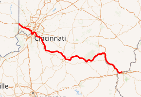
U.S. Route 52 (US 52) runs east–west across the southern part of the state of Ohio along the Ohio River, passing through or very near the cities and towns of Cincinnati, New Richmond, Point Pleasant, Moscow, Neville, Chilo, Rural, Utopia, Higginsport, Ripley, Aberdeen, Manchester, Wrightsville, Rome, Sandy Springs, Rockville, Friendship, Alexandria, Portsmouth, New Boston, Sciotoville, Sciotodale, Wheelersburg, Franklin Furnace, Hanging Rock, Ironton, Coal Grove, South Point, and Burlington.
| ||||
|---|---|---|---|---|
| Ohio River Scenic Byway | ||||
| ||||
| Route information | ||||
| Maintained by ODOT | ||||
| Length | 180.968 mi[1] (291.240 km) | |||
| Major junctions | ||||
| West end | ||||
| East end | ||||
| Location | ||||
| Counties | Hamilton, Clermont, Brown, Adams, Scioto, Lawrence | |||
| Highway system | ||||
| ||||

For its first 19 miles (31 km) or so, the highway is overlapped with Interstate 74 (I-74) and I-75 before it winds through downtown Cincinnati for several miles. The route is primarily two lanes between New Richmond and west of Portsmouth, where it becomes a four-lane partial access highway until it exits the state.
Major intersections
| County | Location | mi[1][2] | km | Exit | Destinations | Notes |
|---|---|---|---|---|---|---|
| Hamilton | Harrison Township | 0.000 | 0.000 | Continuation into Indiana | ||
| Harrison | 1.600 | 2.575 | 1 | New Haven Road – Harrison | ||
| 3.580 | 5.761 | 3 | Dry Fork Road | |||
| Whitewater Township | 5.850 | 9.415 | 5 | Western end of I-275 overlap; I-275 exit 25 | ||
| 7.760 | 12.489 | 7 | ||||
| Colerain Township | 9.330 | 15.015 | 9 | Eastern end of I-275 overlap; I-275 exit 28 | ||
| Green Township | 11.160 | 17.960 | 11 | Rybolt Road, Harrison Pike | ||
| 14.660 | 23.593 | 14 | North Bend Road – Cheviot | |||
| Cincinnati | 17.440 | 28.067 | Montana Avenue | Westbound exit and eastbound entrance | ||
| 18.400– 18.520 | 29.612– 29.805 | Western end of US 27 overlap; No direct access from I-74/US 52 west to Beekman Street south or from Beekman Street north to I-74/US 52 east, however, a legal U-turn allows both of these accesses to be achieved | ||||
| 19.470 | 31.334 | 4 | Eastern end of I-74 overlap; western end of I-75 overlap | |||
| 19.930– 20.401 | 32.074– 32.832 | 3 | Eastern end of I-75 overlap | |||
| 20.7 | 33.3 | Western end of US 127 overlap | ||||
| 23.3 | 37.5 | Central Parkway (US 42 north) | Western end of US 42 overlap eastbound | |||
| 23.4 | 37.7 | West Ninth Street (US 22 west / SR 3 west) | ||||
| 23.5 | 37.8 | Near western end of US 42 overlap westbound | ||||
| 23.7 | 38.1 | On ramps only | ||||
| 23.9 | 38.5 | Eastern end of US 42 / US 127 overlap | ||||
| 25.227 | 40.599 | East Pete Rose Way (US 27 south | Eastern end of US 27 overlap | |||
| 33.807– 34.207 | 54.407– 55.051 | 72 | Western end of I-275 overlap | |||
| Anderson Township | 35.367– 35.687 | 56.918– 57.433 | 71 | Eastern end of I-275 overlap | ||
| 35.937– 36.287 | 57.835– 58.398 | Kellogg Avenue west | Interchange | |||
| Clermont | Pierce Township | 41.657 | 67.040 | Western terminus of SR 749 | ||
| New Richmond | 45.607 | 73.397 | Southern terminus of SR 132 | |||
| Point Pleasant | 50.587 | 81.412 | Western terminus of SR 232 | |||
| Moscow | 53.137 | 85.516 | Western end of SR 743 overlap | |||
| Washington Township | 53.517 | 86.127 | Eastern end of SR 743 overlap | |||
| Chilo | 60.867 | 97.956 | ||||
| Rural | 63.657 | 102.446 | Southern terminus of SR 133 | |||
| Brown | Higginsport | 70.161 | 112.913 | Southern terminus of SR 505 | ||
| 70.634 | 113.674 | Southern terminus of SR 221 | ||||
| Ripley | 78.351 | 126.094 | Western end of US 62 / US 68 overlap | |||
| Aberdeen | 84.106– 84.111 | 135.355– 135.364 | Eastern end of US 68 overlap; temporary eastern end of US 62 overlap | |||
| 86.281 | 138.856 | Southern terminus of SR 41 | ||||
| 86.546 | 139.282 | Traditional eastern end of US 62 overlap; Simon Kenton Memorial Bridge temporarily closed for repairs | ||||
| Adams | Manchester | 97.293 | 156.578 | Southern terminus of SR 136 | ||
| Monroe Township | 102.500 | 164.958 | ||||
| Scioto | Friendship | 131.368 | 211.416 | Eastern terminus of SR 125 | ||
| Washington Township | 135.718– 136.038 | 218.417– 218.932 | Interchange; southern terminus of SR 239 | |||
| 136.508– 136.998 | 219.688– 220.477 | Interchange; western end of US 23 Truck overlap | ||||
| Portsmouth | 138.028– 138.128 | 222.135– 222.295 | Eastern end of US 23 Truck overlap; northern terminus of US 23 Truck; This is made up of separate one-way intersections | |||
| New Boston | 141.778 | 228.170 | Southern terminus of SR 139 | |||
| 141.778 | 228.170 | Begin expressway | ||||
| Sciotoville | 143.608 | 231.115 | Eastbound exit only; southern terminus of SR 335 | |||
| 143.938– 144.108 | 231.646– 231.919 | Westbound exit and entrance only | ||||
| 144.838 | 233.094 | Western terminus of SR 140; only SR 823 and Chillicothe signed eastbound | ||||
| Sciotodale | 145.098 | 233.513 | Southern terminus of SR 823; westbound exit and eastbound entrance | |||
| Wheelersburg | 146.718 | 236.120 | Center Street - Wheelersburg | Interchange | ||
| Porter Township | 149.458 | 240.529 | Western terminus of SR 522 | |||
| Green Township | 152.498 | 245.422 | Eastern terminus of SR 253 | |||
| 152.968 | 246.178 | Old US 25 / CR 1 | Eastbound exit and westbound entrance | |||
| Lawrence | Hamilton Township | 160.008 | 257.508 | |||
| Hanging Rock | 162.628 | 261.724 | Southern terminus of SR 650; western terminus of US 23 Bus | |||
| Ironton–Upper Township line | 165.288 | 266.005 | ||||
| 166.388 | 267.776 | Western terminus of SR 141 | ||||
| Coal Grove | 168.468 | 271.123 | Western terminus of SR 243; eastern terminus of US 52 Bus | |||
| 169.618– 169.648 | 272.974– 273.022 | Ashland KY (SR 652 south) | Partially at-grade; northern terminus of SR 652 | |||
| South Point | 175.448 | 282.356 | Solida Road - South Point | |||
| Union Township | 180.638– 180.668 | 290.709– 290.757 | Southern terminus of SR 7 | |||
| Ohio River | 180.968 | 291.240 | Continuation into West Virginia | |||
1.000 mi = 1.609 km; 1.000 km = 0.621 mi
| ||||||
References
- "DESTAPE". Ohio Department of Transportation. Retrieved June 13, 2020.
- Google (June 13, 2020). "U.S. Route 52 in Ohio" (Map). Google Maps. Google.
|access-date=requires|url=(help) No URL entered.
External links

| Previous state: Indiana |
Ohio | Next state: West Virginia |