Turner's Gap
Turner's Gap is a wind gap in the South Mountain Range of the Blue Ridge Mountains, located in Frederick County and Washington County, Maryland. The gap is traversed by U.S. Route 40 Alternate, the old National Pike. The Appalachian Trail also crosses the gap along the ridgeline.[1]
| Turner's Gap | |
|---|---|
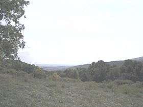 Looking east across the Middletown Valley at Catoctin Mountain from Turners Gap | |
| Elevation | 1,070 ft (326 m) |
| Traversed by | |
| Location | Maryland, United States |
| Range | Blue Ridge Mountains South Mountain |
| Coordinates | 39°29′05″N 77°37′13″W |
Geography
The gap is 200 feet (61 m) below the ridgline to the south, 400 feet (120 m) below the ridgline to the south and 400 feet (120 m) above the surrounding lowlands. To the east of the gap lies the Middletown Valley and to the west the Hagerstown Valley. Fox's Gap is 1 mile (1.6 km) to the south.
History
The Old South Mountain Inn and Dahlgren Chapel are located at Turners Gap.
Turner's Gap was the scene of heavy fighting during the Battle of South Mountain in September 1862 during the American Civil War. The area is listed on the National Register of Historic Places as part of the Turner's and Fox's Gaps Historic District.[2]
References
- "Turners Gap". Geographic Names Information System. United States Geological Survey. Retrieved 2018-10-23.
- "National Register Information System". National Register of Historic Places. National Park Service. April 15, 2008.