Tukey's Bridge
Tukey's Bridge is a bridge connecting the neighborhoods of Munjoy Hill and East Deering in Portland, Maine. It is part of Interstate 295, U.S. Route 1, and State Route 26.
Tukey's Bridge | |
|---|---|
 Tukey's Bridge from the west, above Back Bay. | |
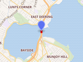
| Coordinates | 43°40′35″N 70°15′23″W |
| Carries | Eight auto lanes; |
| Crosses | Back Cove |
| Locale | Portland, Maine |
| History | |
| Opened | 1960 |
| |
History
Several bridges by the same name have existed connecting the areas.[1][2] The current bridge was completed in 1960 and named for Lemuel Tukey, a tavern owner and tax collector from the Back Cove area of Portland in the late 18th century.[3]
References
- History of Trains in Portland Archived 2011-06-11 at the Wayback Machine University of Southern Maine
- Back Cove Bridge : Tukey's Bridge Archived 2012-07-13 at Archive.today
- I 295 Interstate-guide.com
- "Tukey Bridge". Geographic Names Information System. United States Geological Survey. 30 September 1980. Retrieved 2010-11-03.
The City of Portland, Maine | |
|---|---|
| General | |
| Geography |
|
| Neighborhoods |
|
| Bridges, streets and squares | |
| Sports teams | |
| Metropolitan area |
|
| Education | |
| |
This article is issued from Wikipedia. The text is licensed under Creative Commons - Attribution - Sharealike. Additional terms may apply for the media files.