Truckee Tahoe Airport
Truckee Tahoe Airport[1] (IATA: TKF, ICAO: KTRK, FAA LID: TRK) is a public airport two miles east of Truckee, California.[2] The airport is in both Nevada County and Placer County. It is owned by Truckee Tahoe Airport District,[1] a bi-county special district. The FAA's National Plan of Integrated Airport Systems for 2009–2013 called it a general aviation airport.[3]
Truckee Tahoe Airport | |||||||||||||||
|---|---|---|---|---|---|---|---|---|---|---|---|---|---|---|---|
| Summary | |||||||||||||||
| Airport type | Public | ||||||||||||||
| Owner | Truckee Tahoe Airport District | ||||||||||||||
| Serves | Truckee, California | ||||||||||||||
| Elevation AMSL | 5,901 ft / 1,799 m | ||||||||||||||
| Coordinates | 39°19′12″N 120°08′22″W | ||||||||||||||
| Website | www.TruckeeTahoeAirport.com | ||||||||||||||
| Runways | |||||||||||||||
| |||||||||||||||
| Statistics (2004) | |||||||||||||||
| |||||||||||||||
Many U.S. airports use the same three-letter location identifier for the FAA and IATA, but Truckee Tahoe Airport is TRK to the FAA and TKF to IATA.[4] (IATA lists TRK as Juwata Airport in Tarakan, North Kalimantan, Indonesia.)[5]
Facilities
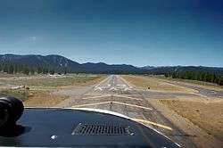
Truckee-Tahoe Airport covers 989 acres (400 ha) at an elevation of 5,900 ft (1,800 m). It has two asphalt runways: 11/29 is 7,000 by 100 ft (2,134 by 30 m) and 2/20 is 4,650 by 75 ft (1,417 by 23 m).[2]
A seasonal control tower opened June 1, 2017 and operated through September 15. The tower reopened in December of 2017 as a year round tower. The tower opens daily at 0700L. Closing times change depending on the season. Check current NOTAMs before departure. The Tower frequency 120.575 is the CTAF when the tower is closed. Ground is 118.3. AWOS is at 118.0, Unicom is 122.80.
In 2016 the District reported 32,524 aircraft operations.
In 2004 the airport had 35,000 aircraft operations, average 95 per day: 97% general aviation, 3% air taxi, and less than 1% military. 91 aircraft were then based at this airport: 80.2% single-engine, 13.2% multi-engine, 2.2% jet, 3.3% glider and 1.1% ultralight.[2]
Runway elevation is 5,900 ft (1,800 m), pattern altitude is 7,000 ft (2,100 m). Both runways are lighted. Density altitude can exceed 9,000 ft (2,700 m) in summer months. Downdrafts can occur on final to RWY 20. Glider pilots use left traffic RWY 20. Powered aircraft use right traffic RWY 20.
100LL and Jet A are available 7am - 7pm, and self serve 100LL is available 7am - 9pm. There are 210 paved tie-downs for transient parking, no landing fees and low overnight tie-down fees.
The airport is attended seven days a week, 7am - 9pm. Snow removal equipment is operated round-the-clock as needed. Pre-heating services and aircraft maintenance are offered by local FBOs. No de-icing services are available.
The airport had a 500-gallon underground heating oil tank removed in 1986. Small amounts of oil that had leaked were monitored and removed; six remaining above-ground tanks were functioning satisfactorily and are regularly tested.[6]
Instrument departures
IFR clearances can be requested from the Tower when in operation and when the tower is closed from Oakland Center on frequency 127.95 which can be reached from most of the field.
References
- Truckee Tahoe Airport, official site
- FAA Airport Master Record for TRK (Form 5010 PDF). Federal Aviation Administration. Effective 8 April 2010.
- National Plan of Integrated Airport Systems for 2009–2013: Appendix A: Part 1 (PDF, 1.33 MB). Federal Aviation Administration. Updated 15 October 2008.
- "Truckee, California - Truckee-Tahoe Airport (IATA: TKF, ICAO: KTRK, FAA: TRK)". Great Circle Mapper. Retrieved 24 May 2010.
- "Tarakan, Borneo, Indonesia - Juwata Airport (IATA: TRK, ICAO: WALR)". Great Circle Mapper. Retrieved 24 May 2010.
- Phase I Environmental Site Assessment, Truckee, California, Earth Metrics Inc., 1989
External links
- Truckee Tahoe Airport, official site
- Aerial image as of 26 August 1998 from USGS The National Map
- FAA Terminal Procedures for TRK, effective June 18, 2020
- Resources for this airport:
- FAA airport information for TRK
- AirNav airport information for KTRK
- ASN accident history for TKF
- FlightAware airport information and live flight tracker
- NOAA/NWS weather observations: current, past three days
- SkyVector aeronautical chart, Terminal Procedures