Trollhätte Canal
The Trollhätte Canal (Swedish: Trollhätte kanal) is a canal in Sweden. Trollhätte Canal connects the Göta river with the lake Vänern. The canal was opened in 1800.[1] Since 2004, the canal proclaimed a national monument.[2]
| Trollhätte Canal | |
|---|---|
 | |
| Location | Västra Götaland County |
| Country | Sweden |
| Specifications | |
| Maximum boat length | 88 m |
| Maximum boat beam | 13.20 |
| Maximum boat draft | 5.40 |
| Locks | 6 |
| Total rise | 44 |
| History | |
| Date of first use | 1800 |
| Geography | |
| Beginning coordinates | 58.387404°N 12.315920°E |
| Ending coordinates | 57.6827°N 11.8535°E |
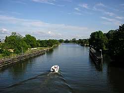
The Trollhätte Canal and the Göta Canal form a greater, 390 km waterway, connecting the Kattegatt (North Sea) and the Baltic Sea through the territory of Sweden. This waterway was dubbed as Sweden's Blue Ribbon (Swedish: Sveriges Blå Band).[3] Contrary to the popular belief it is not correct to consider this waterway is as a sort of the greater Göta Canal. The Trollhätte Canal and the Göta Canal are completely separate entities.[1][4]
Description
Trollhätte Canal[5] | |||||||||||||||||||||||||||||||||||||||||||||||||||||||||||||||||||||||||||||||||||||||||||||||||||||||||||||||||||||||||||||||||||||||||||||||||||||||||||||||||||||||||||||||||||||||||||||||||||||||||||
|---|---|---|---|---|---|---|---|---|---|---|---|---|---|---|---|---|---|---|---|---|---|---|---|---|---|---|---|---|---|---|---|---|---|---|---|---|---|---|---|---|---|---|---|---|---|---|---|---|---|---|---|---|---|---|---|---|---|---|---|---|---|---|---|---|---|---|---|---|---|---|---|---|---|---|---|---|---|---|---|---|---|---|---|---|---|---|---|---|---|---|---|---|---|---|---|---|---|---|---|---|---|---|---|---|---|---|---|---|---|---|---|---|---|---|---|---|---|---|---|---|---|---|---|---|---|---|---|---|---|---|---|---|---|---|---|---|---|---|---|---|---|---|---|---|---|---|---|---|---|---|---|---|---|---|---|---|---|---|---|---|---|---|---|---|---|---|---|---|---|---|---|---|---|---|---|---|---|---|---|---|---|---|---|---|---|---|---|---|---|---|---|---|---|---|---|---|---|---|---|---|---|---|---|
| |||||||||||||||||||||||||||||||||||||||||||||||||||||||||||||||||||||||||||||||||||||||||||||||||||||||||||||||||||||||||||||||||||||||||||||||||||||||||||||||||||||||||||||||||||||||||||||||||||||||||||
The Trollhätte Canal is 82 km long, albeit only 10 km of it is manmade, the rest of its watercourse it was laid out through the riverbed of the Göta Älv river.[6] The highest point of the Trollhätte Canal is at the Lake Vänern – 44.10 m a.s.l..
The canal has six locks (downstream towards Göteborg):[7]
- 1. Brinkebergskulle sluss (6 m) – Vänersborg
- 2. Tvåan (9 m) – Trollhättan upper
- 3-5. Slusstrappan (23 m) – Trollhättan lower, triple lock staircase
- 6. Ströms sluss (6 m) – Lilla Edet, 49 km from Göteborg
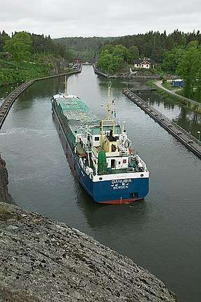
Cargo traffic
The canal is opened for cargo traffic nearly all year round except short periods in winter when it's locks are on maintenance or affected by ice.[1]
The canal is allowing ships up 4000 tonnes to pass it through. Albeit the statistics show that in the beginning of the 21st century the cargo traffic through the canal is in steady decline: in 2015 the volume of freight transferred through the canal is amounted to 1.5 million tonnes while in 1990 it was as large as 3.5 million tonnes. A relevant study suggests this decline exists due to a number of factors. One of them is competition from road and rail transportation, but another one is due to the constrains of the current infrastructure of the canal.[8]
The current locks of the canal were built in 1916. They are not large enough for modern days freighters, thus they do not have sufficient throughput capacity. Another moment is the age of the locks per se. They were built using technology and materials more than a hundred years ago. Despite regular maintenance they struggle to sustain the effects of water and ice. It is estimated that the locks could not be safely used after 2030.[8][9]
In this regard the Swedish transport authorities are planning for 2025-2026 to proceed with the renovation of the canal infrastructure which if to be finished in 2030-2032.[10]
References
- RCC Pilotage Foundation (2017). The Baltic Sea and Approaches. Imray,Laurie,Norie & Wilson Ltd. p. 167. ISBN 978-1846236891.
- "Trollhättans kanal och slussområde". Swedish National Heritage Board. 2020-01-16.
- "Historical and geographical facts on the Göta Canal". Linköpings University. Retrieved 23 January 2020.
- "Maximum size for boats". AB Göta kanalbolag. Retrieved 22 January 2020.
- "Översiktskarta Trollhättekanal" (PDF). Sjöfartsverket. Retrieved 2014-04-05.
- "With yacht on Trollhätte canal" (PDF). Sjöfartsverket. Retrieved 22 January 2020.
- "Passage Plan Trollhätte Canal" (PDF). Sjöfartsverket. Retrieved 22 January 2020.
- "Vänersjöfart - nya slussar i Trollhätte kanal" (PDF). Trafikverket. Retrieved 22 January 2020.
- "Vänersjöfart". Trafikverket. Retrieved 23 January 2020.
- "Vänersjöfart – nya slussar i Trollhätte kanal". Trafikverket. Retrieved 23 January 2020.
- "Vänersjöfart och slussar i Trollhätte kanalByggtekniska alternativ och samhällsekonomiska effekter" (PDF). Trafikverket. Retrieved 16 January 2020.
- "Maxfartyg i Trollhätte kanal". Sjöfartsverket. Retrieved 16 January 2020.