Traill Island
Traill Island (Danish: Traill Ø) is a large island in eastern Greenland. It is named after zoologist Thomas Stewart Traill. The island is a part of the Northeast Greenland National Park.
| Native name: Traill Ø | |
|---|---|
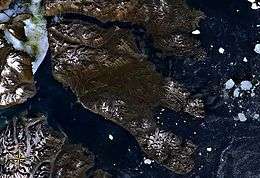 Traill Island seen from space. King Oscar Fjord to the south. | |
 Traill Island | |
| Geography | |
| Location | East-Greenland |
| Coordinates | 72°32′N 23°10′W |
| Area | 3,452 km2 (1,333 sq mi) |
| Highest elevation | 1,884 m (6,181 ft) |
| Highest point | unnamed[1] |
| Administration | |
| Zone | NE Greenland National Park |
| Demographics | |
| Population | 0 |
Geography
Traill Island is a coastal island located in the desolate region of Eastern Greenland on the eastern side of King Oscar Fjord, northeast of Davy Sound. Geographical Society Island lies to the north, separated by a narrow channel, the Vega Sound.
The southernmost point of the island is Cape Simpson. Dream Bay (Drømmebugten) is located 14 km (8.7 mi) WNW of the headland and larger Mountnorris Fjord to the northeast.[2]
The highest summit of the island, a 1,884 metres (6,181 feet) high unnamed peak of the Svinhufvud Range is one of the ultra-prominent summits of Greenland.
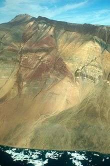 Giant-sized geological fault on the southern side of Traill Island |
References
- Traill High Point
- "Traill Ø". Mapcarta. Retrieved 19 August 2019.