Toyooka, Hyōgo
Toyooka (豊岡市, Toyooka-shi) is a city in the northern part of Hyōgo Prefecture, Japan. The city was founded on April 1, 1950.
Toyooka 豊岡市 | |
|---|---|
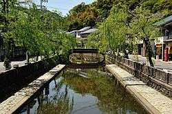  Kinosaki Onsen and Toyooka City Hall | |
 Flag  Chapter | |
 Location of Toyooka in Hyōgo Prefecture | |
 Toyooka Location in Japan | |
| Coordinates: 35°33′N 134°49′E | |
| Country | Japan |
| Region | Kansai |
| Prefecture | Hyōgo Prefecture |
| Government | |
| • Mayor | Muneharu Nakagai |
| Area | |
| • Total | 697.55 km2 (269.33 sq mi) |
| Population (June 1, 2019) | |
| • Total | 78,571 |
| • Density | 112.64/km2 (291.7/sq mi) |
| Symbols | |
| • Tree | Willow |
| • Flower | Tulip |
| • Bird | Oriental white stork |
| Time zone | UTC+9 (JST) |
| City hall address | 2-4 Chūōmachi, Toyooka-shi, Hyōgo-ken 668-8666 |
| Website | www |
As of 1 April 2015, the city has an estimated population of 81,797 with 29,999 households.[1] The total area of Toyooka city is 697.66 km2.
On April 1, 2005, the towns of Kinosaki, Hidaka and Takeno (all from Kinosaki District) and the towns of Izushi and Tantō (both from Izushi District) were merged into Toyooka.
Geography
Toyooka lies entirely within the San'in Kaigan Geopark.[2] One of Toyooka's famous geological features is a basalt cave called Genbudo. Genbudo was formed 1.6 million years ago from the eruption of an ancient volcano. In 1926, Professor Motonori Matuyama of Kyoto University first proposed the theory of geomagnetic polarity reversal at Genbudo after discovering it had a reverse magnetization.
The wetlands of Toyooka provide an important habitat for the oriental stork. After becoming extinct in the wild in the 1970s, Toyooka began a captive breeding program. After a quarter of a century of breeding efforts, the first oriental stork chick was born in 1989. In 2005 Toyooka released 5 captively bred storks, which bred successfully in the wild. As of June 2015 there are 72 wild oriental white storks in Toyooka.
The hot spring resort Kinosaki Onsen is located within Toyooka.
Climate
Although part of the Kansai region and Hyōgo Prefecture, Toyooka has a climate much more similar to the Hokuriku region of Chūbu and Tōhoku. Unlike Osaka or Kobe, which rarely see significant snowfall during the winter, Toyooka, exposed to the northerly winter winds driven by the Siberian High and Aleutian Low, receives 3.1 metres (122.0 in) of snowfall per year, though melt rates are high even during the winter and the maximum cover on the ground is typically only 0.35 metres (13.8 in) and has never exceeded 0.54 metres (21.3 in). Precipitation is much heavier than in central Kansai, though less heavy than in the Kii Peninsula or the Hokuriku region proper.
| Climate data for Toyooka, Hyōgo (1981~2010) | |||||||||||||
|---|---|---|---|---|---|---|---|---|---|---|---|---|---|
| Month | Jan | Feb | Mar | Apr | May | Jun | Jul | Aug | Sep | Oct | Nov | Dec | Year |
| Record high °C (°F) | 21.4 (70.5) |
23.0 (73.4) |
26.7 (80.1) |
32.2 (90.0) |
33.9 (93.0) |
37.2 (99.0) |
39.3 (102.7) |
38.6 (101.5) |
37.9 (100.2) |
32.4 (90.3) |
27.2 (81.0) |
23.1 (73.6) |
39.3 (102.7) |
| Average high °C (°F) | 7.1 (44.8) |
7.9 (46.2) |
12.2 (54.0) |
19.2 (66.6) |
23.8 (74.8) |
27.0 (80.6) |
30.7 (87.3) |
32.5 (90.5) |
27.4 (81.3) |
21.8 (71.2) |
16.1 (61.0) |
10.6 (51.1) |
19.7 (67.5) |
| Average low °C (°F) | 0.1 (32.2) |
−0.1 (31.8) |
2.1 (35.8) |
6.7 (44.1) |
12.1 (53.8) |
17.3 (63.1) |
21.8 (71.2) |
22.7 (72.9) |
18.6 (65.5) |
12.0 (53.6) |
6.7 (44.1) |
2.2 (36.0) |
10.2 (50.4) |
| Record low °C (°F) | −12.5 (9.5) |
−11.1 (12.0) |
−11 (12) |
−3.2 (26.2) |
0.7 (33.3) |
6.0 (42.8) |
13.0 (55.4) |
13.8 (56.8) |
7.9 (46.2) |
2.0 (35.6) |
−2.2 (28.0) |
−9.1 (15.6) |
−12.5 (9.5) |
| Average precipitation mm (inches) | 239.5 (9.43) |
196.2 (7.72) |
148.1 (5.83) |
99.6 (3.92) |
128.7 (5.07) |
155.9 (6.14) |
180.9 (7.12) |
127.0 (5.00) |
225.6 (8.88) |
161.0 (6.34) |
167.1 (6.58) |
197.8 (7.79) |
2,027.4 (79.82) |
| Average snowfall cm (inches) | 126 (50) |
113 (44) |
23 (9.1) |
0 (0) |
0 (0) |
0 (0) |
0 (0) |
0 (0) |
0 (0) |
0 (0) |
1 (0.4) |
44 (17) |
307 (120.5) |
| Average precipitation days (≥ 0.5 mm) | 22.8 | 19.2 | 17.7 | 12.1 | 12.0 | 12.5 | 13.9 | 10.8 | 14.3 | 13.6 | 16.3 | 20.0 | 185.2 |
| Average snowy days | 18.5 | 17.7 | 4.9 | 0.0 | 0.0 | 0.0 | 0.0 | 0.0 | 0.0 | 0.0 | 0.1 | 7.1 | 48.3 |
| Average relative humidity (%) | 83 | 80 | 75 | 70 | 72 | 76 | 78 | 75 | 80 | 81 | 81 | 81 | 78 |
| Mean monthly sunshine hours | 68.8 | 72.9 | 111.1 | 165.3 | 182.5 | 144.8 | 148.1 | 191.9 | 118.2 | 117.8 | 88.8 | 79.3 | 1,489.5 |
| Source 1: Japan Meteorological Agency[3] | |||||||||||||
| Source 2: Japan Meteorological Agency (records)[4] | |||||||||||||
Landmarks
- Kinosaki Onsen
- Izushi
- Takeno Beach
- Kannabe highlands
- Mount Kannabe
- Kinosaki Marine World
- Hyōgo Prefectural Stork Nature Park
- Nakashima Shrine
 Cherry blossoms in Kinosaki Onsen
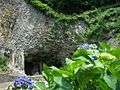 Genbudo cave
 Toyooka City Mascot Gensan
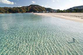 Takeno Beach
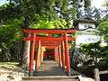 Izushi Castle Inari Shrine
 Toyooka City Oriental white stork
Transportation
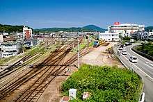
Railway
The Sanin Main Line provides a JR rail connection to Kyoto, and direct trains to Osaka are available via Fukuchiyama. Direct Express trains take about 2.5 hours from Osaka to Toyooka.
Highways
Airport
Tajima Airport serves Toyooka and its area and runs two direct flights a day to Osaka Itami Airport.
Sister cities


References
- Toyooka City Hall statistics 2015 Retrieved 12 June 2015
- "Information on the San'in Kaigan Geopark". San'in Kaigan Geopark Promotion Council. 2008. Retrieved 5 November 2014.
- 平年値(年・月ごとの値) (in Japanese). Japan Meteorological Agency. Retrieved 2011-11-25.
- 観測史上1~10位の値(年間を通じての値) (in Japanese). Japan Meteorological Agency. Retrieved 2011-11-25.
External links
| Wikimedia Commons has media related to Toyooka, Hyogo. |
- Toyooka and Kinosaki Onsen Official Website (in English)
Kobe (capital) | ||
| Wards of Kobe | ||
| Core cities |
| |
| Special cities | ||
| Cities | ||
| Districts | ||
| Authority control |
|
|---|