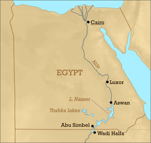
Toshka Lakes
Toshka Lakes (Arabic: بحيرات توشكى, Egyptian Arabic pronunciation: [boħeˈɾæːt ˈtoʃkæ]) is the name given to recently formed endorheic lakes in the Sahara Desert of Egypt.[1]
| Toshka Lakes | |
|---|---|
| Location | New Valley Governorate |
| Coordinates | 23.1°N 30.9°E |
| Type | Endorheic lake |
| Primary inflows | Nile-Lake Nasser via Sadat Canal |
| Basin countries | Egypt |
.jpg)
History
The Aswan High Dam, constructed in Egypt in 1964-1968, created Lake Nasser, with a maximum water level of 183 metres (600 ft) above sea level. In 1978 Egypt began building the Sadat Canal NW from Lake Nasser through Wadi Toshka to allow water levels higher than 178 metres (584 ft) to be drained off into a hollow at the south end of the Eocene limestone plateau. In the late 1990s, water began flowing through the Sadat Canal into the Western Desert. This feeder canal from Lake Nasser is concrete-lined, to reduce seepage losses.
Formation
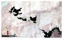
Astronauts began noticing the first, easternmost lake growing in November 1998. By late 1999, three additional lakes formed successively westward, and the westernmost lake started forming sometime between September 2000 and March 2001. These lakes are not yet named individually. In total, the Toshka Lakes cover approximately 1300 square kilometers (502 mi²). The levels of the lakes as of 2006 are lower than in 2001, and areas of wetlands and sand dunes have formed between the former and present shorelines. A minor lake downstream of the three larger lakes has completely dried out. The levels of the lakes vary between 175 metres (574 ft) for the one closest Lake Nasser to 144 metres (472 ft) for the one furthest downstream.
Geography
- The new lake system is endorheic, that is, the waters can never flow on to the sea. The Nile-sourced water creates the lakes and helps to recharge the underlying aquifer; but desert temperatures cause very high levels of evaporation. Although the new lakes already contain an impressive amount of fish, these high evaporation levels will make the waters become increasingly saline over time, reducing fish stocks and harming the newly established flora and fauna.
- The Toshka Hollow lies within the seismically active Nubian Swell. The Egyptian government is developing the surrounding region, also known as the "New Valley Project". The plan is to extend the waterway to the Kharga oasis.
- Use of Nile resources is governed by the Nile Basin Initiative; but the Toshka project does not breach the agreement as water is diverted from Lake Nasser only after heavy water flows upstream have raised lake levels above 178 metres (584 ft) (see above).
See also
- New Valley Project
- New Valley Governorate
- Lakes of Egypt
References
- El-Shabrawy, Gamal M; Henri J. Dumont (2009). The Toshka Lakes. In the Nile. Monographiae Biologicae. 89. pp. 157–162. doi:10.1007/978-1-4020-9726-3_8. ISBN 978-1-4020-9725-6.
Further reading
- Chipman, J. W; T. M. Lillesand (2007). "Satellite‐based assessment of the dynamics of new lakes in southern Egypt". International Journal of Remote Sensing. 28 (19): 4365–4379. doi:10.1080/01431160701241787.