Tonopah Airport
Tonopah Airport (IATA: TPH, ICAO: KTPH, FAA LID: TPH) is a county-owned, public-use airport located seven nautical miles (13 km) east of the central business district of Tonopah, in Nye County, Nevada, United States.[1]
Tonopah Airport | |||||||||||||||
|---|---|---|---|---|---|---|---|---|---|---|---|---|---|---|---|
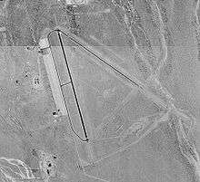 USGS aerial image, 1999 | |||||||||||||||
| Summary | |||||||||||||||
| Airport type | Public | ||||||||||||||
| Owner | Nye County | ||||||||||||||
| Serves | Tonopah, Nevada | ||||||||||||||
| Elevation AMSL | 5,430 ft / 1,655 m | ||||||||||||||
| Coordinates | 38°03′37″N 117°05′12″W | ||||||||||||||
| Runways | |||||||||||||||
| |||||||||||||||
| Statistics (2009) | |||||||||||||||
| |||||||||||||||
It incorporates the former Tonopah Army Airfield, a World War II installation where many units of the USAAF, such as the 357th Fighter Group, trained. The 357th (whose pilots included Chuck Yeager and Bud Anderson among others) later flew P-51 Mustang fighters against the German Luftwaffe, from their base at Leiston, on the south-eastern coast of Britain.
Facilities and aircraft
Tonopah Airport covers an area of 3,820 acres (1,550 ha) at an elevation of 5,430 feet (1,655 m) above mean sea level. It has two asphalt paved runways: 15/33 is 7,161 by 80 feet (2,183 x 24 m) and 11/29 is 6,196 by 50 feet (1,889 x 15 m).[1]
For the 12-month period ending November 30, 2009, the airport had 12,727 aircraft operations, an average of 34 per day: 74% general aviation, 25% air taxi, and 2% military. At that time six aircraft were based here: 5 single-engine and 1 helicopter.[1]
References
- FAA Airport Master Record for TPH (Form 5010 PDF). Federal Aviation Administration. Effective July 29, 2010.
External links
| Wikimedia Commons has media related to Tonopah Airport. |
- "Diagram of Tonopah Airport (TPH)" (PDF). Archived from the original (PDF) on 2016-03-04. from Nevada DOT
- FAA Airport Diagram (PDF), effective June 18, 2020
- FAA Terminal Procedures for TPH, effective June 18, 2020
- Resources for this airport:
- FAA airport information for TPH
- AirNav airport information for KTPH
- ASN accident history for TPH
- FlightAware airport information and live flight tracker
- NOAA/NWS weather observations: current, past three days
- SkyVector aeronautical chart, Terminal Procedures