Tioga Peak
Tioga Peak is technically outside of Yosemite National Park, a bit north-north-east of Tioga Pass. It is in the Inyo National Forest.[2]
| Tioga Peak | |
|---|---|
 Tioga Peak | |
| Highest point | |
| Elevation | 11,526 ft (3,513 m) NAVD 88[1] |
| Prominence | 1,006 ft (307 m) [1] |
| Coordinates | 37°56′58″N 119°14′47″W [1] |
| Geography | |
| Location | Mono County, California, California, U.S. |
| Parent range | Ritter Range |
| Climbing | |
| Easiest route | Scramble, class 2 "Tioga Peak". SummitPost.org. Retrieved 2008-10-31. |
The location of Tioga Peak
Tioga Peak is north of Tioga Pass, at the head of Lee Vining Canyon. Highway 120 goes direct past its south and east slopes. It is easily accessible, a class 1 to class 2 scramble, from Gardisky Lake. The summit is like a rolling dome. It has some of the best views of the Tioga Pass region.[2]
Both Mount Dana and Tioga Pass are visible, from the summit.[2]
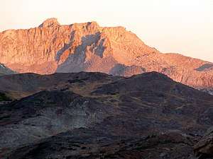
Tioga Peak is a rounded peak, made of metamorphic rock.[2]
References
- "Tioga Peak, California". Peakbagger.com. Retrieved 2019-02-06.
- Noondueler. "Tioga Peak". summitpost.org. Retrieved 11 February 2019.
External links and references
This article is issued from Wikipedia. The text is licensed under Creative Commons - Attribution - Sharealike. Additional terms may apply for the media files.