Three Bays Protected Area
Three Bays Protected Area (Aire Protégée de Ressources Naturelles Gérées des Trois Baies) is the second largest declared protected area in Haiti after the Port Salut/Aquin Protected Area (Aire Protégée de Ressources Naturelles Gérées de Port Salut/Aquin) and the first protected area in the country to be co-managed between the Agence Nationale des Aires Protégées (ANAP) of the Ministry of the Environment and the non-governmental/non-profit organization Fondation pour la Protection de la Biodiversité Marine (FoProBiM).
| Three Bays Protected Area | |
|---|---|
IUCN category IV (habitat/species management area) | |
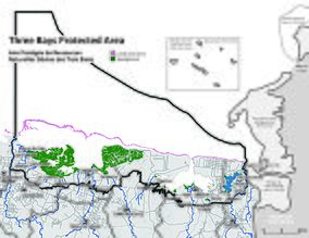 Three Bays Protected Area boundaries | |
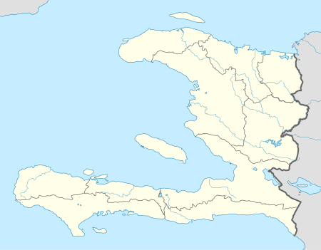 | |
| Location | Haiti |
| Nearest city | Cap-Haïtien |
| Coordinates | 19.8°N 72.0°W |
| Area | 75,406 ha (291.14 sq mi) |
| Established | 2014 |
| Governing body | co-managed by ANAP and FoProBiM |
The Three Bays Protected Area has a boundary perimeter of approximately 170 km (110 mi) encompassing over 75,000 ha (190,000 acres). The area contains some of the most extensive and healthiest fringing and barrier coral reefs, seagrass beds, and mangrove forests in the country, which provide critical coastal protection and ecosystem services for its seaside communities. The area is biologically productive but extremely overfished by many regional communities.
This IUCN Category IV — Habitat/Species Management Area was created by Presidential Decree on March 21 (2014)[1][2] to protect its unique marine complex of fringing and barrier coral reefs, seagrass beds, mangrove forests, deep offshore waters, and adjoining coastal plains known for their diverse aquatic and brackish water habitats and dry tropical forests. The region is also of historical importance having witnessed centuries of human history dating from pre-Columbian times and indigenous Taino occupations, to the arrival of Christopher Columbus and the sequence of world-altering events through Spanish and French colonization and the Haitian Revolution. The mountaintop fortress of the Citadelle Laferrière, a UNESCO World Heritage Site located approximately 10 miles (16 km) southwest, provides a birds-eye view of the Three Bays Protected Area.
The east–west boundary of the Three Bays Protected Area extends for over 40 km (25 mi) from Massacre River (bordering the Dominican Republic, where it is known as Dajabón River) to the Grande-Rivière-du-Nord to the west. The north–south boundary extends from the 12 mi (19 km) territorial sea limit inland to the 10-m topographic contour line. The western boundary is near Cap-Haïtien, Haiti's second largest city and capital of the Nord (Haitian department), served by Hugo Chávez International Airport and the Port international du Cap-Haïtien. The eastern boundary includes Fort Liberté, the capital of the Nord-Est (department), which is one of the oldest cities in the country and where Haiti's independence was proclaimed. The protected area is also directly adjacent to the 'Parque Nacional Manglares de Estero Balsa'[3] in the Dominican Republic, near the city of 'San Fernando de Monte Cristi', as well as national parks 'Parque Nacional Submarino de Monte Cristi',[4] Parque Nacional el Morro'.[5] marine refuge 'Cayos Sietes Hermanos'[6] and wildlife refuge 'Laguna Saladilla'.[7]
-_Creation_Aire_Protegee_des_Trois_Baies.pdf.jpg) Le Moniteur (21 Mars 2014)- Creation Aire Protegee des Trois Baies
Le Moniteur (21 Mars 2014)- Creation Aire Protegee des Trois Baies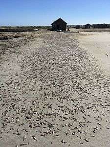 Sun-dried fish in Caracol, Nord-Est
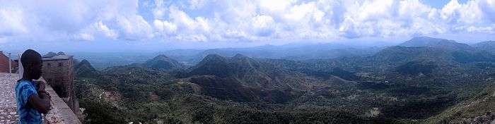 Three Bays Protected Area on the horizon (from Citadelle Laferrière)
References
- "New marine protected area in Haiti". IUCN. February 7, 2014.
- "MPAtlas » Submarino Monte Cristi". www.mpatlas.org.
- "MPAtlas » El Morro". www.mpatlas.org.
- "MPAtlas » Cayos Siete Hermanos". www.mpatlas.org.
Henwood W.D., Aucoin, S., and Turner M. (2017) The Protected Area of Managed Natural Resources of the Three Bays. Management Plan 2017–2027. Fondation pour la Protection de la Biodiversité Marine (FoProBiM), The Nature Conservancy (TNC) and The National Agency of Protected Areas (ANAP), Haiti. 155 p.