The Wrythe
The Wrythe is a district of Carshalton, South London, located in the London Borough of Sutton. The area is located 9.3 miles South of Charing Cross and is surrounded by the adjacent areas of Hackbridge and Croydon to the East, Morden and Mitcham to the North, Sutton to the west. the Area is commonly referred to as Wrythe Green which is present at the centre of the neighbourhood. It is thought that the name derives from a spring which is thought to be related to the River Wandle which runs through the East of the area from the Carshalton ponds. The Wrythe had a population of 10,163 in the 2011 Census.
Toponymy and human history
The Place-names of Surrey notes the Anglo-Saxon Proto-Germanic /raɪð/ describes two high-gradient streams in the county (see The Rythe). The name is onomatopoeic, see ripple. It is a short, important tributary of the Wandle, as receives water from potent springs.
The Wrythe area's history dates back to the Roman era however was mostly developed in the 18th century, with large development taking place in the 1930s. The population of the associated ward is 10,384 residents.[1][2]
Facilities
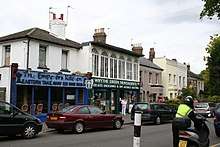
The Wrythe, about 1 mile (1.6 km) from the centre of Carshalton, has many independent restaurants and shops including an Marks & Spencer food store and a branch of competitor Nisa.[3]
Carshalton College is located in the Wrythe area,[1] and it also contains four primary schools:
- Victor Seymour Infants School
- Camden Junior School
- Muschamp Primary
- Rushy Meadow Primary[1]
Transport links
The Wrythe Green, traversed by short roads and surrounded by shops is centred 400 metres north of Carshalton Railway Station, the area is within walking distance of Hackbridge railway station and Mitcham Junction providing access to London Trams. The nearest London Underground station is Morden, which is two miles from the area.
The area is served by the bus routes 127 to Tooting and Purley, 151 to Worcester Park and Wallington and 157 Morden, Croydon and Crystal Palace. The 151 serves the centre and main road of the Wrythe.[4] whereas the 157 serves the M&S branch[5] and the 127 serves the college.[6]
References
- "The Wrythe". Sutton Council. Archived from the original on 9 November 2013. Retrieved 9 November 2013.
- "Sutton Ward population 2011". Neighbourhood Statistics. Office for National Statistics. Retrieved 9 October 2016.
- "Nisa Extra, Green Wrythe Lane". Nisa Retail. Retrieved 17 January 2020.
- "Bus map for route 151". Transport for London. Retrieved 9 November 2013.
- "Bus map for route 157". Transport for London. Retrieved 9 November 2013.
- "Bus map for route 127". Transport for London. Retrieved 9 November 2013.