The Geysers
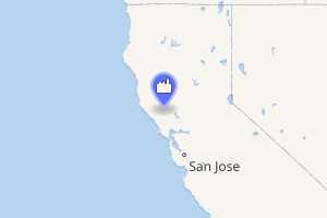
The Geysers is the world's largest geothermal field, containing a complex of 18 geothermal power plants, drawing steam from more than 350 wells, located in the Mayacamas Mountains approximately 72 miles (116 km) north of San Francisco, California.
| The Geysers | |
|---|---|
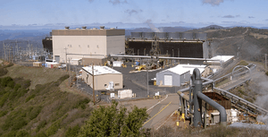 The Sonoma Calpine 3 power plant is one of 18 power plants at The Geysers | |
| |
| Official name | The Geysers |
| Country | United States |
| Location | Sonoma and Lake counties California |
| Coordinates | 38°47′26″N 122°45′21″W |
| Status | Operational |
| Commission date | September 1960 [1] |
| Owner(s) | Calpine Corporation (86.5%) NCPA (4.5%) Silicon Valley Power (4.5%) USRG (4.5%) |
| Operator(s) | Calpine Corporation |
| Geothermal power station | |
| Type | Dry steam |
| Wells | 376 (active) [1] 591 (total) [1] |
| Max. well depth | 12,900 ft (3,900 m) [1] |
| Site area | 29,000 acres (120 km2) [1] |
| Power generation | |
| Units operational | 22 units (18 power stations) |
| Units planned | 3 units |
| Units decommissioned | 7 units (4 power stations) |
| Nameplate capacity | 1,590 MW [2] |
| Capacity factor | 53% [2] |
| Annual net output | 6,516 GWh (2018) [3] |
| External links | |
| Commons | Related media on Commons |
Geysers produced about 20% of California's renewable energy in 2019.[4]
History
For about 12,000 years, Native American tribes built steambaths at the Geysers and used the steam and hot water for healing purposes and cooking.[5] When European Americans first entered the area, six Indian tribes inhabited the area around the Geysers, three bands of Pomo people, two bands of Wappo people, and the Lake Miwok people.[5] The Wappo also collected sulfur which they called te'ke and a Wappo village, named tekena'ntsonoma (teke sulphur + nan well containing water + tso ground + no'ma village) was located about 12 miles (19 km) southeast of Cloverdale and on the present-day Sulphur Creek.[5] Today, Calpine Corporation generates power at the site and no Native American groups receive direct financial benefits from the operation. [6]
The Geysers were first seen by European Americans and named in 1847 during John Fremont's survey of the Sierra Mountains and the Great Basin by William Bell Elliot who called the area "The Geysers," although the geothermal features he discovered were not technically geysers, but fumaroles.[7]
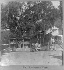
Between 1848 and 1854, Archibald C. Godwin developed The Geysers into a spa named The Geysers Resort Hotel, which attracted tourists including Ulysses S. Grant, Theodore Roosevelt and Mark Twain.[5] [7][8] The resort declined in popularity in the mid 1880s, and rebranded itself to appeal to lower-income people.[5] In 1938, the main building was destroyed in a landslide although the bar/restaurant, small cabins and the swimming pool stayed open, despite another fire in March 1957, until about 1979.[5] In 1960, Pacific Gas and Electric began operation of their 11-megawatt geothermal electric plant at the Geysers. Unocal Corporation dismantled the remains of the resort in 1980.[5]
Five of the Geysers facilities were damaged in the Valley Fire of September 2015, suffering "severe" damage to their cooling towers. The main power houses were not damaged.[9]The Kincade Fire was reported burning at John Kincade Road and Burned Mountain Road in The Geysers, at 9:27 PM on October 23, 2019.[10][11] The fire started at 9:24 PM during an extreme wind event,[12] and subsequently burned 77,758 acres (31,468 ha) until the fire was fully contained on November 6.
Geothermal development
The Geysers is the world's largest geothermal field[13] spanning an area of around 30 square miles (78 km2) in Sonoma, Lake and Mendocino counties in California, centered in the area of Geyser Canyon and Cobb Mountain. Power from The Geysers provides electricity to Sonoma, Lake, Mendocino, Marin, and Napa counties. It is estimated that the development meets 60% of the power demand for the coastal region between the Golden Gate Bridge and the Oregon state line.[14] Unlike most geothermal resources, the Geysers is a dry steam field which mainly produces superheated steam.[13]
Steam used at The Geysers is produced from a greywacke sandstone reservoir, capped by a heterogeneous mix of low permeability rocks and underlaid by a silicic intrusion.[7][15] Gravity and seismic studies suggest that the source of heat for the steam reservoir is a large magma chamber over 4 miles (6.4 km) beneath the surface, and greater than 8 miles (13 km) in diameter.[16]
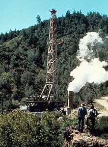
The first geothermal wells drilled in Geyser Canyon were the first in the Western Hemisphere.[5] The first power plant at the Geysers was privately developed by the owner of The Geysers Resort[5] and opened in 1921, producing 250 kilowatts of energy to light the resort.[7] In 1960, Pacific Gas and Electric began operation of their 11-megawatt plant at the Geysers.[17] The original turbine lasted for more than 30 years and produced 11 MW net power.[18]
By 1999 the steam to power extraction had begun to deplete the Geysers steam field and production began to drop.[7] However, since October 16, 1997, the Geysers steam field has been recharged by injection of treated sewage effluent, producing approximately 77 megawatts of capacity in 2004.[19] The effluent is piped up to 50 miles (80 km) from its source at the Lake County Sanitation waste water treatment plants and added to the Geysers steam field via geothermal injection.[19] In 2003, the City of Santa Rosa and Calpine Corporation partnered on constructing a 42-mile pipeline that became known at the Santa Rosa Geysers Recharge Project (SRGRP). Since 2003, SRGRP has delivered approximately 11 million gallons per day of tertiary treated wastewater to replenish The Geysers’ geothermal reservoir. In 2004, 85% of the effluent produced by four waste-water treatment plants serving 10 Lake County communities was diverted to the Geysers steam field.[19] Injecting treated water into the Geysers field increases the amount of power that can be generated.[19]
The injection of wastewater to the Geysers protects local waterways and Clear Lake by diverting effluent which used to be put into surface waters,[19] and has produced electricity without releasing greenhouse gases into the atmosphere.[7]
Geothermal power stations
This is a table of all constituent geothermal power stations sorted by unit identification.[2]
Calpine owns 19 existing units, most of which were acquired from PG&E and Unocal Geothermal in 1999. NCPA Units 1-4 are jointly owned by the Northern California Power Agency (NCPA) and Silicon Valley Power. Bottle Rock is wholly owned by Bottle Rock Power LLC, a joint-venture between U.S. Renewables Group and Riverstone Holdings.[2]
In addition, Ormat owns the plans for a new 30 MW geothermal power station at the vacant Calpine 15 site that were acquired through a merger with U.S. Geothermal in 2018. The plans were previously developed by Ram Power before being sold to U.S. Geothermal in 2014.[2][20][21]
| Name | Unit | Type | Status | Capacity (MW) |
Commissioned | Decommissioned |
|---|---|---|---|---|---|---|
| Bottle Rock | BRP | Dry steam | Operational | 55 | March 1985 [note 1] October 2007 | |
| Aidlin | Calpine 1 | Dry steam | Operational | 20 | June 1989 | |
| Bear Canyon | Calpine 2 | Dry steam | Operational | 20 | September 1988 | |
| Sonoma | Calpine 3 | Dry steam | Operational | 78 | October 1983 | |
| West Ford Flat | Calpine 4 | Dry steam | Operational | 27 | December 1988 | |
| McCabe | Calpine 5 | Dry steam | Operational | 55 | December 1971 | |
| Calpine 6 | Dry steam | Operational | 55 | December 1971 | ||
| Ridge Line | Calpine 7 | Dry steam | Operational | 55 | November 1972 | |
| Calpine 8 | Dry steam | Operational | 55 | November 1972 | ||
| Fumarole | Calpine 9 | Dry steam | Offline since 2001 | 55 | November 1973 | |
| Calpine 10 | Dry steam | Offline since 2000 | 55 | November 1973 | ||
| Eagle Rock | Calpine 11 | Dry steam | Operational | 110 | May 1975 | |
| Cobb Creek | Calpine 12 | Dry steam | Operational | 110 | March 1979 | |
| Big Geysers | Calpine 13 | Dry steam | Operational | 60 | May 1980 | |
| Sulfur Springs | Calpine 14 | Dry steam | Operational | 114 | September 1980 | |
| PG&E 15 [note 2] | Calpine 15 | Dry steam | Decommissioned | 62 | June 1979 | 1997 (Dismantled) |
| Quicksilver | Calpine 16 | Dry steam | Operational | 119 | October 1985 | |
| Lake View | Calpine 17 | Dry steam | Operational | 119 | December 1982 | |
| Socrates | Calpine 18 | Dry steam | Operational | 119 | February 1983 | |
| Calistoga | Calpine 19 | Dry steam | Operational | 80 | April 1984 | |
| Grant | Calpine 20 | Dry steam | Operational | 119 | October 1985 | |
| Buckeye | Calpine | Dry steam | Planned | ? | TBD | |
| Wild Horse | Calpine | Dry steam | Planned | ? | TBD | |
| Coldwater Creek | CCPA 1 | Dry steam | Decommissioned | 65 | May 1988 | 2000 (Dismantled) |
| CCPA 2 | Dry steam | Decommissioned | 65 | October 1988 | 2000 (Dismantled) | |
| NCPA 1 & 2 | NCPA 1 | Dry steam | Operational | 55 | February 1983 | |
| NCPA 2 | Dry steam | Operational | 55 | February 1983 | ||
| NCPA 3 & 4 | NCPA 3 | Dry steam | Operational | 55 | November 1985 | |
| NCPA 4 | Dry steam | Operational | 55 | November 1985 | ||
| TBD | Ormat | Dry steam | Planned | 30 | TBD | |
| PG&E 1 & 2 | PG&E 1 | Dry steam | Decommissioned | 12 | September 1960 | 1993 (Dismantled) |
| PG&E 2 | Dry steam | Decommissioned | 14 | September 1960 | 1993 (Dismantled) | |
| PG&E 3 & 4 | PG&E 3 | Dry steam | Decommissioned | 28 | March 1963 | 1995 (Dismantled) |
| PG&E 4 | Dry steam | Decommissioned | 28 | March 1963 | 1995 (Dismantled) |
- Bottle Rock was re‐commissioned in October 2007 after being brought offline in 1991 by its former owner DWR.
- Calpine never renamed PG&E 15 due to its decommissioning two years before being acquired from PG&E and Unocal Geothermal.
Seismicity
For the past several decades, small earthquakes (less than 2.0) are regularly recorded in the area.[22] This has been demonstrated to be caused by the water injection process used to produce the geothermal electricity at the power plant.[23]
According to the Lawrence Berkeley National Laboratory Earth Sciences division, seismicity was very low prior to the use of the Geyser steam field for geothermal energy, although this may have been the result of low seismic coverage of the area.[24] Before 1969, there were no earthquakes above magnitude 2 recorded by the United States Geological Survey (USGS) in an approximately 70 square miles (180 km2) area around the Geysers.[24] Studies have shown that injecting water into the Geysers field produces earthquakes from magnitude 0.5 to 3.0, although a 4.6 occurred in 1973 and magnitude four events increased thereafter.[24] Even with increasing injection rates over time, the rate of magnitude 3 earthquakes has remained relatively unchanged since the 1980s,[24] although the absolute number of earthquakes has increased significantly.[7] A magnitude 4.5 earthquake struck near the Geysers on January 12, 2014 and a magnitude 5.0 on December 14, 2016.[25] Despite the increases in the number of earthquakes and the fears of local residents, it is unlikely that a large earthquake will occur at the Geysers since there is no fault or fracture nearby.[7]
Geochemistry
In 2005, abatement equipment was installed at two of the Geysers plants to reduce the amount of mercury released by the waste vapor even though the amount released was below the legal limit for such releases.[13] The Geysers Air Monitoring Programs (GAMP) has shown limited releases of arsenic, but again below a significant level.[13]
Production
Power plants at the Geysers are of the dry steam power plant type, where the steam directly powers the generator.[13] In general, the Geysers has 1517 MW[26] of active installed capacity with an average production factor of 63% (955 MW).[27]
Of nearly two dozen active plants in the Geysers in 2013, Calpine Corporation operated 19 plants in 2004[28] but only 15 in 2013.[29] Two other plants are owned jointly by the Northern California Power Agency and the City of Santa Clara's municipal Electric Utility (now called Silicon Valley Power). The Bottle Rock Power plant, owned by the U.S. Renewables Group, was reopened in 2007.[30] In July 2009, AltaRock Energy planned to drill more than 2 miles (3.2 km) down to create an "enhanced geothermal" project which was abandoned when federal agencies asked for review.[7] Another plant was under development by Ram Power Corporation, formerly Western Geopower, in 2010, but after Ram Power lost both its CEO and CFO in 2013, it was seeking a buyer for its Geysers property.[31]
Geology
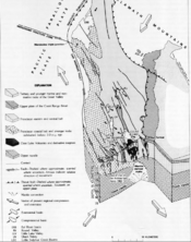
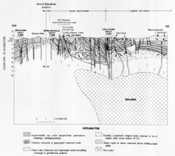
The Geysers is located on the northeast limb of the Mayacamas anticline, bounded by the Collayomi Fault on the northeast and the Mercuryville Fault on the southwest. The central and eastern Franciscan belts form the core of this anticline. Within this belt is a rock unit forming the reservoir rock, consisting of a sheared and fractured graywacke. A large Bouguer Gravity anomaly combined with slower seismic velocities, located below the Clear Lake Volcanic Field, suggests a magma body is heating the geothermal area.[32]
See also
References
- "Geysers By The Numbers". geysers.com. Retrieved 2020-02-02.
- "The Geysers Geothermal Field Update1990/2010". OSTI 1048267. 2010-10-01. OSTI 1048267. Cite journal requires
|journal=(help) - "Electricity Data Browser - List of plants for geothermal, California, all sectors". www.eia.gov. Retrieved 2020-02-02.
- McCarthy, Will (2020-02-06). "The pros and cons of enhanced geothermal energy systems". Yale Climate Connections. Retrieved 2020-02-17.
- Hodgson, Susan F. (2010). A Geysers Album: Five Eras of Geothermal History (PDF). Sacramento: State of California Department of Conservation. pp. 1–81. Retrieved February 9, 2014.
- http://geysers.com/About-Calpine/Community-Commitment
- The Future of Energy: Earth, Wind and Fire. Scientific American. April 8, 2013. pp. 160–. ISBN 978-1-4668-3386-9. Retrieved February 9, 2014.
- "A History of Geothermal Energy in the United States". U.S. Department of Energy. 2010. Archived from the original on September 4, 2007. Retrieved May 17, 2007.
- "Valley Fire Devastates Facilities At The Geysers Geothermal Power Plant". CBS Bay Area. 2015. Retrieved September 16, 2015.
- Chabria, Anita; Dolan, Maura (October 27, 2019). "Blackouts and mass evacuations as Kincade fire grows amid high winds". Los Angeles Times. Retrieved October 27, 2019.
- Graff, Amy (2019-10-24). "Map: Kincade Fire burning in north Sonoma County". SFGate. Retrieved 2019-11-06.
- "Kincade Fire: Why PG&E is on the hot seat again over latest devastating wildfire". The Mercury News. 2019-10-25. Retrieved 2019-11-06.
- Kagel, Alyssa; Diana Bates; Karl Gawell. A Guide to Geothermal Energy and the Environment (PDF). Geothermal Energy Association. Retrieved February 9, 2014.
- "Calpine Corporation - The Geysers". Retrieved 2008-06-11.
- Enedy, Steve; Kathy Enedy; John Maney (1991). Reservoir Response To Injection In The Southeast Geysers (PDF). Sixteenth Workshop on Geothermal Reservoir Engineering. Retrieved May 16, 2007.
- "Cascades Volcanic Observatory (USGS) - Clear Lake Volcanic Field, California". Retrieved May 16, 2007.
- Lund, J. (September 2004), "100 Years of Geothermal Power Production" (PDF), Geo-Heat Centre Quarterly Bulletin, Klamath Falls, Oregon: Oregon Institute of Technology, 25 (3), pp. 11–19, ISSN 0276-1084, retrieved April 13, 2009
- McLarty, Lynn; Reed, Marshall J. (October 1992). "The U.S. Geothermal Industry: Three Decades of Growth" (PDF). Energy Sources, Part A: Recovery, Utilization, and Environmental Effects. London: Taylor & Francis. 14 (4): 443–455. doi:10.1080/00908319208908739. ISSN 1556-7230.
- Dellinger, Mark; Eliot Allen (May–June 2004). Geothermal and the Environment Lake County Success: Generating environmental gains with geothermal Power (PDF). Lake County, California.
- "Ormat Technologies Inc. - Press Release". investor.ormat.com. Retrieved 2020-02-17.
- "Ram Power becomes Polaris Infrastructure Inc". Think GeoEnergy - Geothermal Energy News. Retrieved 2020-02-18.
- http://scedc.caltech.edu/recent/Maps/San_Francisco.html
- https://www.usgs.gov/faqs/why-are-there-so-many-earthquakes-geysers-area-northern-california?qt-news_science_products=0#qt-news_science_products
- "EGS: The Geysers: What is the history of seismicity at The Geysers?". Induced seismicity. Lawrence Berkeley National Laboratory, Earth Sciences Division. Retrieved February 9, 2014.
- "M4.5 - 6km NW of The Geysers, California". United States Geological Survey. Retrieved February 9, 2014.
- Ronald DiPippo (2008). Geothermal Power Plants: Principles, Applications, Case Studies and Environmental Impact. Elsevier Science & Technology. ISBN 978-0-7506-8620-4.
- Lund, John W.; Bloomquist, R. Gordon; Boyd, Tonya L.; Renner, Joel (24–29 April 2005), The United States of America Country Update (PDF), Proceedings World Geothermal Congress, Antalya, Turkey, retrieved 2009-11-09
- Ann Chambers (2004). Renewable Energy in Nontechnical Language. PennWell Books. pp. 143–. ISBN 978-1-59370-005-8.
- Wilkison, Brett (November 15, 2013). "Sonoma Clean Power makes deal with Geysers operator". Santa Rosa Press Democrat. Retrieved February 9, 2014.
- Baker, David R. (January 14, 2007). "Steamy industry may clear the air". San Francisco Chronicle. Lake County. p. F-1. Retrieved November 11, 2009.
- Davis, Tina (January 28, 2013). "Ram Power CEO and CFO to Depart, Seeks Buyer for Geysers Project". Bloomberg News. Retrieved February 9, 2014.
- McLaughlin, Robert (1981). McLaughlin, Robert; Donnelly-Nolan, Julie (eds.). Tectonic Setting of Pre-Tertiary Rocks and Its Relation to Geothermal Resources in the Geysers-Clear Lake Area, in Research in the Geysers-Clear Lake Geothermal Area, Northern California, USGS Professional Paper 1141. Washington: US Government Printing Office. pp. 9–11.
External links
| Wikimedia Commons has media related to The Geysers. |
- Jeremy Shere (November 26, 2013). Renewable: The World-Changing Power of Alternative Energy. St. Martin's Press. pp. 151–. ISBN 978-1-250-03822-7.
- "EGS: Interactive, Real-Time Map of Earthquakes at The Geysers". Induced Seismicity. Lawrence Berkeley National Laboratory, Earth Sciences Division. Retrieved February 9, 2014.
- A Geysers Album: History of The Geysers Geothermal field (Report). California Department of Conservation. Division of Oil, Gas, and Geothermal Resources. 1992.
- U.S. Geological Survey Professional Paper. U.S. Government Printing Office. 1996. pp. 3–.