Texas State Highway 315
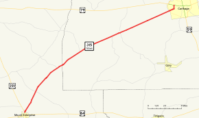
State Highway 315 or SH 315 is a state highway in Texas that runs from Mount Enterprise northeast to Carthage.[1]
| ||||
|---|---|---|---|---|
 | ||||
| Route information | ||||
| Maintained by TxDOT | ||||
| Length | 26.035 mi[1] (41.899 km) | |||
| Existed | 1939–present | |||
| Major junctions | ||||
| West end | ||||
| East end | ||||
| Location | ||||
| Counties | Rusk, Panola | |||
| Highway system | ||||
| ||||

Route description
SH 315 begins at a junction with US 259 in Mount Enterprise.[2] The route travels to the northeast through eastern Rusk County, intersecting FM 95 and FM 840.[3] Continuing to the northeast, the highway enters Panola County, in which it has junctions with FM 348, FM 1971, and FM 1970 in the community of Clayton. SH 315 then enters Carthage, where it intersects SH 149. The route travels through the western portion of Carthage before reaching its eastern terminus at Bus. US 79.[4]
History
A very similar route was originally designated as SH 215 in 1935. This route was not built, and was removed from the state highway system by 1939. SH 315 was designated on April 1, 1939 on its current route.[5] When originally constructed, the route between Mount Enterprise and the former community of Shiloh, approximately 5.8 miles to the east, was the first road in the state's Farm to Market system.[6][7] This route became part of SH 315 during the 1939 redescription of the state highway system.[1]
Major intersections
| County | Location | mi[8] | km | Destinations | Notes |
|---|---|---|---|---|---|
| Rusk | Mount Enterprise | 0.0 | 0.0 | Western terminus | |
| | 3.4 | 5.5 | |||
| | 7.9 | 12.7 | |||
| Panola | | 11.7 | 18.8 | ||
| | 16.6 | 26.7 | |||
| Clayton | 17.7 | 28.5 | |||
| Carthage | 24.8 | 39.9 | |||
| 26.0 | 41.8 | Eastern terminus | |||
| 1.000 mi = 1.609 km; 1.000 km = 0.621 mi | |||||
References
- Transportation Planning and Programming Division (n.d.). "State Highway No. 315". Highway Designation Files. Texas Department of Transportation. Retrieved 2008-03-15.
- Transportation Planning and Programming Division (2012). Texas County Mapbook (PDF) (Map) (2012 ed.). 1:120,000. Texas Department of Transportation. p. 574. OCLC 867856197.
- Transportation Planning and Programming Division (2012). Texas County Mapbook (PDF) (Map) (2012 ed.). 1:120,000. Texas Department of Transportation. p. 573. OCLC 867856197.
- Transportation Planning and Programming Division (2012). Texas County Mapbook (PDF) (Map) (2012 ed.). 1:120,000. Texas Department of Transportation. p. 591. OCLC 867856197.
- (PDF) https://publicdocs.txdot.gov/minord/MinuteOrderDocLib/003676259.pdf. Missing or empty
|title=(help) - Texas Department of Transportation. "Farm/Ranch to Market Facts". Retrieved 2011-04-04.
- Hudson, Ann. "Shiloh, TX (Rusk County)". Handbook of Texas Online. Texas State Historical Association. Retrieved 2011-04-04.
- Google (2011-04-04). "Overview map of Texas State Highway 315 Distances Between Interchanges" (Map). Google Maps. Google. Retrieved 2011-04-04.